
فائل:Baltoro region from space annotated.png

ایس وکھالے دا ناپ: ۶۳۳ × ۶۰۰ پکسلز۔ دوجے ریزولوشنز: ۲۵۳ × ۲۴۰ پکسلز | ۵۰۷ × ۴۸۰ پکسلز | ۸۱۱ × ۷۶۸ پکسلز | ۱,۰۸۱ × ۱,۰۲۴ پکسلز | ۲,۳۳۶ × ۲,۲۱۳ پکسلز ۔
اصل فائل (۲,۳۳۶ × ۲,۲۱۳ پکسلز, فائل حجم: ۹.۸۴ میگابائٹ, MIME type: image/png)
| تفصیل |
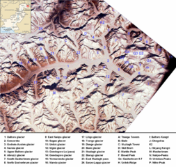
English: Baltoro region from space. Many mountains (e.g. K2, Broad Peak, Gasherbrums, Trango Towers) and glaciers are marked. |
| تریخ |
(UTC) 2000-02-14 |
| سروت | |
| لکھاری |
|
| دوجے ورژن | Image:Baltororegion aus dem Weltraum - deutsch.png (deutsche Beschriftung - German Annotations) |
| This is a retouched picture, which means that it has been digitally altered from its original version. Modifications: ISS-image rotated, cropped, marked, pk-map.png included, region marked with a red circle. The original can be viewed here: Karakoram ISS.jpg:
|
| This is a retouched picture, which means that it has been digitally altered from its original version. Modifications: ISS-image rotated, cropped, marked, pk-map.png included, region marked with a red circle. The original can be viewed here: Pk-map.png:
|
ایس فائل نوں کریٹو کامنز Attribution 2.5 پولینڈ لائسنس دتا گیا.
- تہانوں کھلھ اے:
- حصہ کرنا – کاپی، ونڈنا تے کم بھیجنا
- فیر رلانا – کم نوں فٹ کرنا
- تھلے دتیاں شرطاں نال:
- کس دے ناں – تسیں لازمی ایس کم دے بناں والے بارے دسو جنج اونے آکھیا اے یا جنج لسنس چ آکھیا گیا ہے۔
- اکو جہا شئیر کرو۔ – اگر تسیں بدلدے یا ایس کم تے بناندے تے بنن والے کم نوں اینج دے لسنس نال ای ونڈو گے۔
پہلا اپلوڈ دا ریکارڈ
This image is a derivative work of the following images:
- Image:Pk-map.png licensed with PD-USGov-CIA-WF
- 2005-03-04T20:56:46Z Alfio 330x354 (14233 Bytes) CIA map of Pakistan
Uploaded with derivativeFX
فائل دی تریخ
فائل نو اس ویلے دی حالت وچ ویکھن واسطے تاریخ/ویلے تے کلک کرو۔
| تریخ تے ویلہ | نکی مورت | پاسے | ورتن والا | تیپّݨی کرو | |
|---|---|---|---|---|---|
| موجودہ | ۲۰:۵۶, ۲۱ نومبر ۲۰۰۸ | | ۲,۳۳۶ × ۲,۲۱۳ (۹.۸۴ میگابائٹ) | Rupert Pupkin | {{Information |Description={{en|1=Baltoro region from space. Many mountains (e.g. K2, Broad Peak, Gasherbrums, Trango Towers) and glaciers are marked. |Source=*Image:Pk-map.png |Date=2008-11-21 15:50 (UTC) |Author=*derivative work: ~~~ *[[:Image:Pk- |
فائل دی ورتوں
تھلے دتے گئے 1 صفحے اس فائل نال جُڑدے نیں
فائل ویاپک ورتوں
ایہہ دوجے وکیاں ایس فائل نوں ورتدے نیں –
- arz.wikipedia.org تے ورتوں
- az.wikipedia.org تے ورتوں
- bn.wikipedia.org تے ورتوں
- ca.wikipedia.org تے ورتوں
- da.wikipedia.org تے ورتوں
- de.wikipedia.org تے ورتوں
- en.wikipedia.org تے ورتوں
- es.wikipedia.org تے ورتوں
- eu.wikipedia.org تے ورتوں
- fa.wikipedia.org تے ورتوں
- fr.wikipedia.org تے ورتوں
- gl.wikipedia.org تے ورتوں
- hi.wikipedia.org تے ورتوں
- hu.wikipedia.org تے ورتوں
- incubator.wikimedia.org تے ورتوں
- it.wikipedia.org تے ورتوں
- ja.wikipedia.org تے ورتوں
- ko.wikipedia.org تے ورتوں
- lld.wikipedia.org تے ورتوں
- mai.wikipedia.org تے ورتوں
ایس فائل دا ویکھو ہور جگت ورتن .