
فائل:Derwentcroped.jpg
اس توں وڈی مورت موجود نہیں۔
Derwentcroped.jpg (۲۲۴ × ۴۵۳ پکسلز, فائل حجم: ۱۹ کلوبائٹ, MIME type: image/jpeg)
خلاصہ
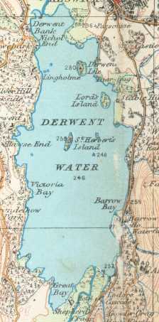
Derwent Water on a 1925 Ordnance Survey map
- This work is in the public domain because it is an Ordnance Survey map over 50 years old. Ordnance Survey maps are covered by crown copyright which in this case expires 50 years after publication. Ordnance Survey does however ask that they be credited and that the date of publication be given. Any ancillary rights gained through the creation of the electronic version are granted as freely usable under any circumstances.
لائسنس –
This work is an Ordnance Survey map over 50 years old, which is covered by Crown Copyright which in this case expires 50 years after publication. Ordnance Survey does however ask that they be credited and that the date of publication be given.
Any ancillary rights gained through the creation of the electronic version are granted as freely usable under any circumstances.
|
This work created by the United Kingdom Government is in the public domain.
This is because it is one of the following:
HMSO has declared that the expiry of Crown Copyrights applies worldwide (ref: HMSO Email Reply)
|
 |
فائل دی تریخ
فائل نو اس ویلے دی حالت وچ ویکھن واسطے تاریخ/ویلے تے کلک کرو۔
| تریخ تے ویلہ | نکی مورت | پاسے | ورتن والا | تیپّݨی کرو | |
|---|---|---|---|---|---|
| موجودہ | ۰۳:۲۲, ۱۸ اکتوبر ۲۰۰۶ | | ۲۲۴ × ۴۵۳ (۱۹ کلوبائٹ) | Voyager | == Summary == Derwent Water on a 1925 Ordnance Survey map :This work is in the public domain because it is an Ordnance Survey map over 50 years old. Ordnance Survey maps are covered by crown copyright which in this case expires 50 years after publication |
فائل دی ورتوں
تھلے دتے گئے 1 صفحے اس فائل نال جُڑدے نیں
فائل ویاپک ورتوں
ایہہ دوجے وکیاں ایس فائل نوں ورتدے نیں –
- cy.wikipedia.org تے ورتوں
- de.wikipedia.org تے ورتوں
- it.wikipedia.org تے ورتوں
- nl.wikipedia.org تے ورتوں
- nn.wikipedia.org تے ورتوں
- ru.wikipedia.org تے ورتوں
- simple.wikipedia.org تے ورتوں