
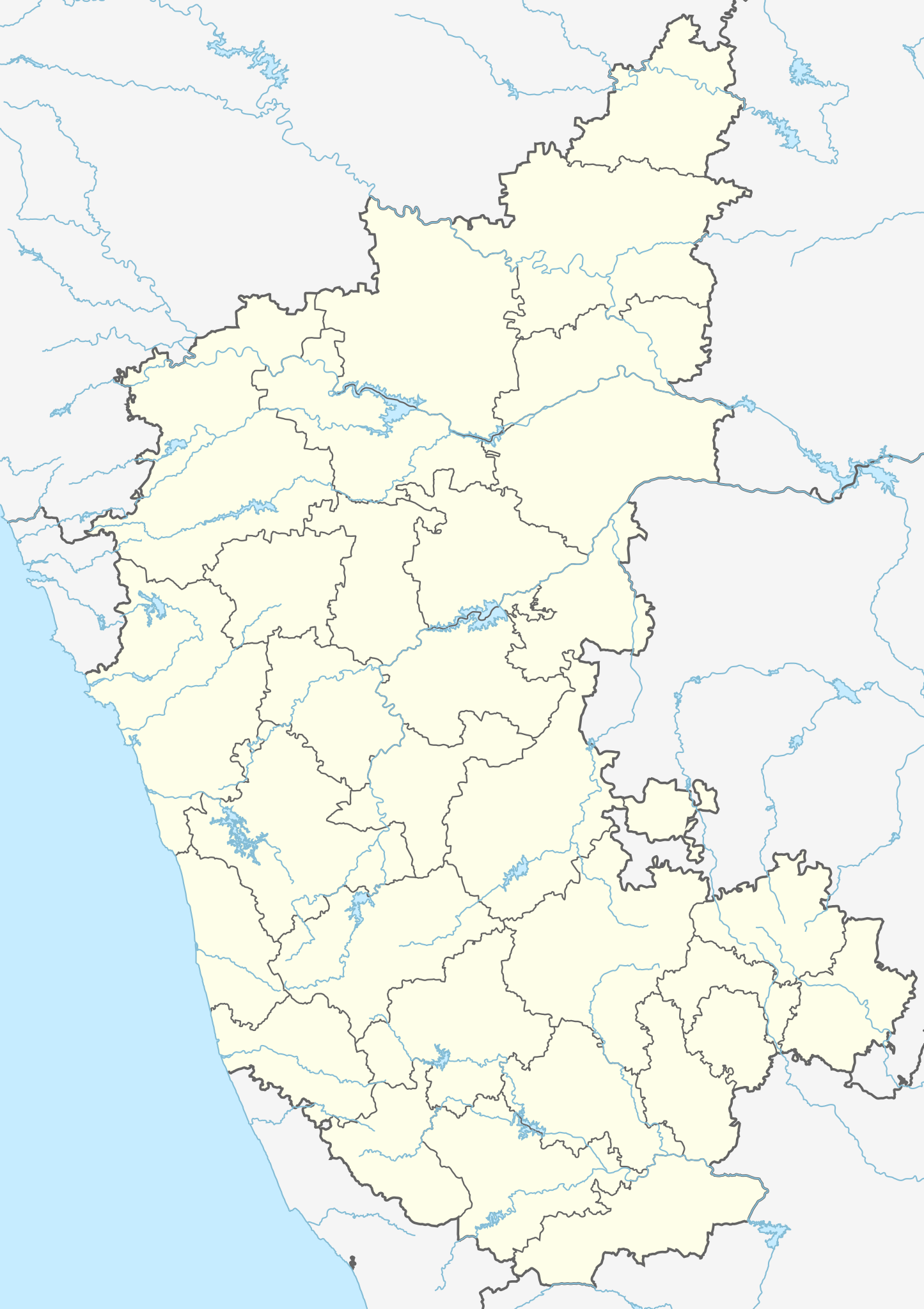
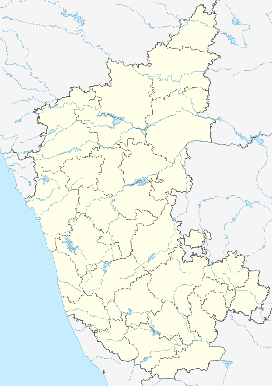
فائل:India Karnataka location map.svg

Size of this PNG preview of this SVG file: ۴۲۳ × ۶۰۰ پکسلز. دوجے ریزولوشنز: ۱۶۹ × ۲۴۰ پکسلز | ۳۳۸ × ۴۸۰ پکسلز | ۵۴۲ × ۷۶۸ پکسلز | ۷۲۲ × ۱,۰۲۴ پکسلز | ۱,۴۴۵ × ۲,۰۴۸ پکسلز | ۸۹۸ × ۱,۲۷۳ پکسلز ۔
اصل فائل (ایس وی جی فائل، پکسل:۸۹۸ × ۱,۲۷۳، فائل سائز: ۷۵۹ کلوبائٹ)
| تفصیل |
Location map of Karnataka Geographic limits of the map:
|
| تریخ | (UTC) |
| سروت | |
| لکھاری |
|
| دوجے ورژن |
Derivative works of this file: |
| This is a retouched picture, which means that it has been digitally altered from its original version. Modifications: Created 3 new districts Chikkaballapur, Ramanagara and Yadgir. Changed conventions per WP:WPMAP. The original can be viewed here: Karnataka locator map.svg:
|
ایس فائل نوں کریٹو کامنز Attribution 2.5 پولینڈ لائسنس دتا گیا.
- تہانوں کھلھ اے:
- حصہ کرنا – کاپی، ونڈنا تے کم بھیجنا
- فیر رلانا – کم نوں فٹ کرنا
- تھلے دتیاں شرطاں نال:
- کس دے ناں – تسیں لازمی ایس کم دے بناں والے بارے دسو جنج اونے آکھیا اے یا جنج لسنس چ آکھیا گیا ہے۔
- اکو جہا شئیر کرو۔ – اگر تسیں بدلدے یا ایس کم تے بناندے تے بنن والے کم نوں اینج دے لسنس نال ای ونڈو گے۔
پہلا اپلوڈ دا ریکارڈ
This image is a derivative work of the following images:
- File:Karnataka_locator_map.svg licensed with Cc-by-sa-3.0
- 2007-05-06T13:55:02Z Planemad 1630x2356 (231773 Bytes) {{WikiProject_India_Maps |Title=Karnataka locator Map |Description=Map of [[w:Karnataka]] with road and rail lines |Source= [http://aquarium.lipetsk.ru/discovery/India2004/karnataka-map.jpg Karnataka Map], [http://www.indianr
Uploaded with derivativeFX
فائل دی تریخ
فائل نو اس ویلے دی حالت وچ ویکھن واسطے تاریخ/ویلے تے کلک کرو۔
| تریخ تے ویلہ | نکی مورت | پاسے | ورتن والا | تیپّݨی کرو | |
|---|---|---|---|---|---|
| موجودہ | ۰۸:۱۰, ۱۶ جون ۲۰۲۳ | | ۸۹۸ × ۱,۲۷۳ (۷۵۹ کلوبائٹ) | C1MM | c Vijayanagara district |
| ۰۹:۴۱, ۱۳ اگست ۲۰۲۱ |  | ۸۵۱ × ۱,۲۱۱ (۵۸۲ کلوبائٹ) | C1MM | Added more rivers | |
| ۰۸:۳۳, ۱۶ جولائی ۲۰۲۱ |  | ۸۵۱ × ۱,۲۱۱ (۵۶۱ کلوبائٹ) | C1MM | Added more accurate district boundaries | |
| ۰۴:۴۱, ۱۵ دسمبر ۲۰۲۰ |  | ۱,۶۳۴ × ۲,۳۶۷ (۳۴۱ کلوبائٹ) | C1MM | Fixed boundaries of Vijayanagara district | |
| ۰۳:۱۰, ۱۵ دسمبر ۲۰۲۰ |  | ۱,۶۳۴ × ۲,۳۶۷ (۳۴۵ کلوبائٹ) | C1MM | Added boundaries of AP/Telangana and rivers | |
| ۰۰:۲۶, ۱۴ دسمبر ۲۰۲۰ |  | ۱,۶۳۴ × ۲,۳۶۷ (۳۴۲ کلوبائٹ) | C1MM | Fixed district boundaries of Ballari and added Vijayanagara district | |
| ۰۸:۵۳, ۲۱ اپریل ۲۰۲۰ |  | ۱,۶۳۴ × ۲,۳۶۷ (۲۸۹ کلوبائٹ) | C1MM | Added rivers | |
| ۲۰:۵۰, ۱۵ نومبر ۲۰۱۰ |  | ۱,۶۳۰ × ۲,۳۵۶ (۲۰۷ کلوبائٹ) | Nayvik | Changed background color | |
| ۲۰:۳۴, ۱۵ نومبر ۲۰۱۰ |  | ۱,۶۳۰ × ۲,۳۵۶ (۲۰۶ کلوبائٹ) | Nayvik | {{Information |Description=Location map of Karnataka Geographic limits of the map: * 18.5°N * 11.0°N * 73.6°E * 78.7°E |Source=*File:Karnataka_locator_map.svg, [http://www.censusindia.gov.in/2011-Images/ADMINI2011.jpg Census In |
فائل دی ورتوں
تھلے دتے گئے 25 صفحے اس فائل نال جُڑدے نیں
- ارسیکیری
- بسوا کلیان
- رائےچور
- شیواموگا
- ضلع اتراکانااڈا
- ضلع باگلکوٹ
- ضلع بیجاپور (کرناٹک)
- ضلع بیدر
- ضلع بیلارے
- ضلع دیوانگری
- ضلع شہری بنگلور
- ضلع شیموگا
- ضلع ٹمکر
- ضلع چمراجنگر
- ضلع چکبالاپور
- ضلع چکماگالر
- ضلع ڈاکشینا کاناڈا
- ضلع کوپال
- ضلع ہسن
- ضلع ہویری
- ٹمکر
- ڈاوانگری
- ہبلی
- ہوسپٹ
- سانچہ:Location map India Karnataka
فائل ویاپک ورتوں
ایہہ دوجے وکیاں ایس فائل نوں ورتدے نیں –
- ar.wikipedia.org تے ورتوں
- as.wikipedia.org تے ورتوں
- azb.wikipedia.org تے ورتوں
- تومکور
- بنقلور
- عباسی، کارناتاکا
- اودقولام
- پیکلیهال
- اوداجی (هیندوستان)
- اوچیلا, اودوپی دیستریکت
- اوچاواد
- او خاناپور
- ویراهانوماکاناپالیا
- فاجیر (هیندوستان)
- پتالور (هیندوستان)
- پت آماپور
- ویراکامبا
- ویراپور
- وانور (هیندوستان)
- ساتیجری
- ساتانور, ماقادی
- ساتانور, بانقالور
- ساسالاتی
- سارقور
- ساراواد
- ساراپادی
- ساپتاساقار
- سانتور
- سانتکاسالاجر
- مایاکوندا
- ساناتی
- ماویناکر
- ماوالی
- ماتیواد
- کالادکا
- سانیکاتا
- کالکونت
- کالکری
- ماتماری
- سانقاناهالا
- کالجی (هیندوستان)
- سانقامشوارا, کالاقاتاجی
- ماتاداکوروباراهاتی
- ماستیهولی
- کالاسا, کوندقول
- ماسارکال
- ماسابینال
ایس فائل دا ویکھو ہور جگت ورتن .