
فائل:Kastamonu districts.png
ایس وکھالے دا ناپ: ۷۷۶ × ۶۰۰ پکسلز۔ دوجے ریزولوشنز: ۳۱۱ × ۲۴۰ پکسلز | ۶۲۱ × ۴۸۰ پکسلز | ۹۹۴ × ۷۶۸ پکسلز | ۱,۰۵۶ × ۸۱۶ پکسلز ۔
اصل فائل (۱,۰۵۶ × ۸۱۶ پکسلز, فائل حجم: ۳۹ کلوبائٹ, MIME type: image/png)
خلاصہ
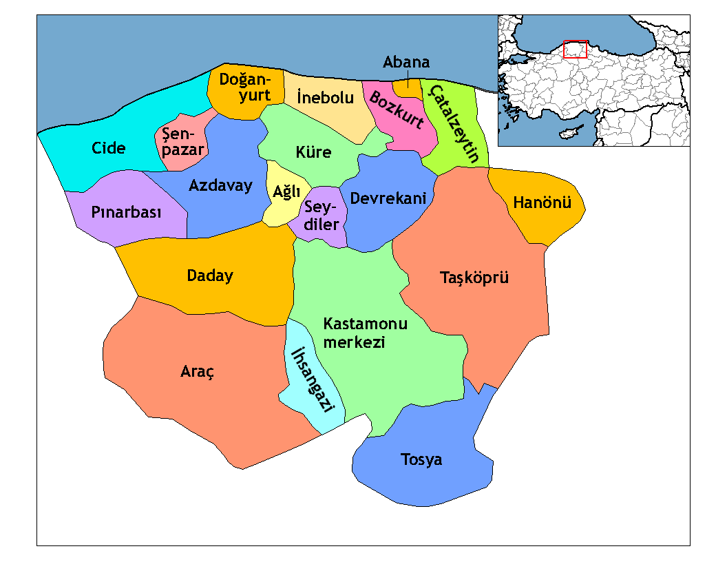
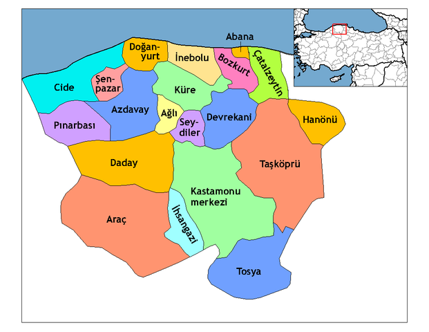
| تفصیل | Map of the districts of Kastamonu province in Turkey. Created by Rarelibra 21:59, 1 December 2006 (UTC) for public domain use, using MapInfo Professional v8.5 and various mapping resources. Edited by One Homo Sapiens Corrected text where İ,Ş,ı,ğ,or ş occurs in name. Source: [statoids-com]. Increased font size and enhanced color differences among adjacent districts. |
| تریخ | ۱ دسمبر ۲۰۰۶ (original upload date) |
| سروت | No machine-readable source provided. Own work assumed (based on copyright claims). |
| لکھاری | No machine-readable author provided. Rarelibra assumed (based on copyright claims). |

|
This locator map image could be re-created using vector graphics as an SVG file. This has several advantages; see Commons:Media for cleanup for more information. If an SVG form of this image is available, please upload it and afterwards replace this template with
{{vector version available|new image name}}.
It is recommended to name the SVG file “Kastamonu districts.svg”—then the template Vector version available (or Vva) does not need the new image name parameter. |
لائسنس –
| میں، اس کم دے کاپیرائٹ دا مالک، اس کم نوں لوکاں واسطے دیندا واں۔ اے سارے جگ واسطے لاگو اے۔ کج ملکاں چ قانونی طور تے اے ممکن نئیں اے؛ اگر انج ای اے ے: میں ہر کسے نوں اس کم نوں کسے وی مقصد واسطے ورتن دا بغیر کسے شرط دے حق دیندا واں، اگر اوہ قانون دے خلاف نا ہوۓ۔ |
[[Category:
]]
فائل دی تریخ
فائل نو اس ویلے دی حالت وچ ویکھن واسطے تاریخ/ویلے تے کلک کرو۔
| تریخ تے ویلہ | نکی مورت | پاسے | ورتن والا | تیپّݨی کرو | |
|---|---|---|---|---|---|
| موجودہ | ۰۴:۵۲, ۲۹ دسمبر ۲۰۰۸ | | ۱,۰۵۶ × ۸۱۶ (۳۹ کلوبائٹ) | One Homo Sapiens | Corrected text where İ,Ş,ı,ğ,or ş occurs in name. Source: [statoids-com]. Increased font size and enhanced color differences among adjacent districts. |
| ۰۲:۵۹, ۲ دسمبر ۲۰۰۶ |  | ۱,۰۵۶ × ۸۱۶ (۳۷ کلوبائٹ) | Rarelibra | Map of the districts of Kastamonu province in Turkey. Created by ~~~~ for public domain use, using MapInfo Professional v8.5 and various mapping resources. |
فائل دی ورتوں
تھلے دتے گئے 21 صفحے اس فائل نال جُڑدے نیں
فائل ویاپک ورتوں
ایہہ دوجے وکیاں ایس فائل نوں ورتدے نیں –
- ar.wikipedia.org تے ورتوں
- arz.wikipedia.org تے ورتوں
- ast.wikipedia.org تے ورتوں
- av.wikipedia.org تے ورتوں
- azb.wikipedia.org تے ورتوں
- az.wikipedia.org تے ورتوں
- ca.wikipedia.org تے ورتوں
- de.wikipedia.org تے ورتوں
- diq.wikipedia.org تے ورتوں
- el.wikipedia.org تے ورتوں
- en.wikipedia.org تے ورتوں
- Kastamonu Province
- User talk:Rarelibra/Maps4
- Districts of Turkey
- Governor of Kastamonu
- List of populated places in Kastamonu Province
- Abana District
- Ağlı District
- Kastamonu District
- Araç District
- Azdavay District
- Bozkurt District, Kastamonu
- Çatalzeytin District
- Cide District
- Daday District
- Devrekani District
- Doğanyurt District
- Hanönü District
- İhsangazi District
ایس فائل دا ویکھو ہور جگت ورتن .