
فائل:Long Island US map.gif
اس توں وڈی مورت موجود نہیں۔
Long_Island_US_map.gif (۴۲۲ × ۳۵۹ پکسلز, فائل حجم: ۱۵ کلوبائٹ, MIME type: image/gif)
خلاصہ
| تفصیل |
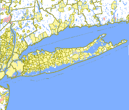
English: US Government Census map of Long Island. |
| سروت | http://tiger.census.gov/cgi-bin/mapsurfer?infact=2&outfact=2&act=move&tlevel=-&tvar=-&tmeth=i&mlat=&mlon=&msym=bigdot&mlabel=&murl=&lat=40.8744240&lon=-72.9908829&wid=1.492&ht=1.492&conf=mapnew |
| لکھاری |
لائسنس –
This image or file is a work of a United States Census Bureau employee, taken or made as part of that person's official duties. As a work of the U.S. federal government, the image is in the public domain.
|
 |
پہلا اپلوڈ دا ریکارڈ
Transferred from en.wikipedia to Commons by Quibik using CommonsHelper.
The original description page was here. All following user names refer to en.wikipedia.
- 2007-01-22 19:12 Badagnani 422×359× (15241 bytes) US Government Census map of [[Long Island, New York]]. From http://tiger.census.gov/cgi-bin/mapsurfer?infact=2&outfact=2&act=move&tlevel=-&tvar=-&tmeth=i&mlat=&mlon=&msym=bigdot&mlabel=&murl=&lat=40.8744240&lon=-72.9908829&wid=1.492&ht=1.492&conf=mapnew.
فائل دی تریخ
فائل نو اس ویلے دی حالت وچ ویکھن واسطے تاریخ/ویلے تے کلک کرو۔
| تریخ تے ویلہ | نکی مورت | پاسے | ورتن والا | تیپّݨی کرو | |
|---|---|---|---|---|---|
| موجودہ | ۰۸:۱۱, ۱۵ جنوری ۲۰۱۲ | | ۴۲۲ × ۳۵۹ (۱۵ کلوبائٹ) | File Upload Bot (Magnus Manske) | {{BotMoveToCommons|en.wikipedia|year={{subst:CURRENTYEAR}}|month={{subst:CURRENTMONTHNAME}}|day={{subst:CURRENTDAY}}}} {{Information |Description={{en|US Government Census map of en:Long Island, New York. From http://tiger.census.gov/cgi-bin/mapsu |
فائل دی ورتوں
تھلے دتے گئے 1 صفحے اس فائل نال جُڑدے نیں
فائل ویاپک ورتوں
ایہہ دوجے وکیاں ایس فائل نوں ورتدے نیں –
- bn.wikipedia.org تے ورتوں
- el.wikipedia.org تے ورتوں
- en.wikipedia.org تے ورتوں