
فائل:Map AP dist all shaded.png
ایس وکھالے دا ناپ: ۷۰۲ × ۵۹۹ پکسلز۔ دوجے ریزولوشنز: ۲۸۱ × ۲۴۰ پکسلز | ۵۶۲ × ۴۸۰ پکسلز | ۹۲۲ × ۷۸۷ پکسلز ۔
اصل فائل (۹۲۲ × ۷۸۷ پکسلز, فائل حجم: ۱۱۰ کلوبائٹ, MIME type: image/png)

|
This map image could be re-created using vector graphics as an SVG file. This has several advantages; see Commons:Media for cleanup for more information. If an SVG form of this image is available, please upload it and afterwards replace this template with
{{vector version available|new image name}}.
It is recommended to name the SVG file “Map AP dist all shaded.svg”—then the template Vector version available (or Vva) does not need the new image name parameter. |
خلاصہ
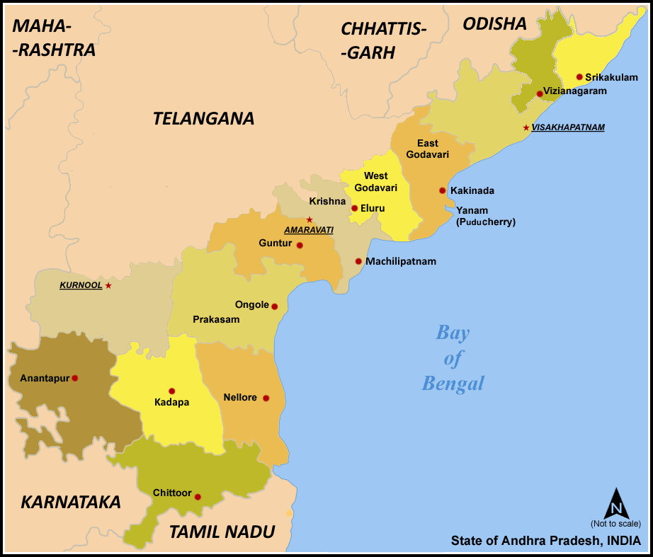
| تفصیل | Map of w:Andhra Pradesh, India with district boundaries - add districts shaded. |
| تریخ | ۷ جنوری ۲۰۰۶ (original upload date) |
| سروت | No machine-readable source provided. Own work assumed (based on copyright claims). |
| لکھاری | No machine-readable author provided. Miljoshi assumed (based on copyright claims). |
| دوجے ورژن | For updated version covering Reorganisation of Andhra Pradesh into Telangana and Andhra Pradesh File:Ap-districts.png |
لائسنس –
میں، اس کم دے کاپیرائٹ دا مالک، اس کم نوں اس لائسنس دے مطابق چھاپدا واں:

|
کاپی کرن، ونڈن تے بدلن دی ایس ڈوکومنٹ لئی اجازت دتی جاندی اے ایہناں GNU Free Documentation License, Version 1.2 شرطاں نال یا مگروں کسے وی چھپے ورین Free Software Foundation توں بنا کسے انویرینٹ سیکشن دے، ناں فرنٹ کور لکھت تے ناں بیک کور لکھت دے۔ لسنس دی اک کاپی سیکشن وچ ہیگی اے جہدا ناں اے GNU Free Documentation License۔ |
| ایس فائل نوں کریٹو کامنز Attribution 2.5 پولینڈ لائسنس دتا گیا. | ||
| ||
| اس لائسنس دا ٹیگ GFDL دے مطابق اس فائل چ پایا گیا اے licensing update۔ |
ایس فائل نوں Creative Commons Attribution-Share Alike 2.5 Generic, 2.0 Generic and 1.0 Generic لسنس دتا گیا اے۔
- تہانوں کھلھ اے:
- حصہ کرنا – کاپی، ونڈنا تے کم بھیجنا
- فیر رلانا – کم نوں فٹ کرنا
- تھلے دتیاں شرطاں نال:
- کس دے ناں – تسیں لازمی ایس کم دے بناں والے بارے دسو جنج اونے آکھیا اے یا جنج لسنس چ آکھیا گیا ہے۔
- اکو جہا شئیر کرو۔ – اگر تسیں بدلدے یا ایس کم تے بناندے تے بنن والے کم نوں اینج دے لسنس نال ای ونڈو گے۔
تسیں اپنی مرضی دا لائسنس چݨ سکدے اوہ۔
فائل دی تریخ
فائل نو اس ویلے دی حالت وچ ویکھن واسطے تاریخ/ویلے تے کلک کرو۔
| تریخ تے ویلہ | نکی مورت | پاسے | ورتن والا | تیپّݨی کرو | |
|---|---|---|---|---|---|
| موجودہ | ۱۲:۵۷, ۸ مارچ ۲۰۲۱ | | ۹۲۲ × ۷۸۷ (۱۱۰ کلوبائٹ) | Sbb1413 | Added the names of unnamed district HQs, plus the surrounding states. Removed the locator map as it (incorrectly) shows Aksai Chin as under the administration of India. |
| ۱۲:۱۵, ۵ مارچ ۲۰۲۱ |  | ۹۲۳ × ۷۹۰ (۱۰۵ کلوبائٹ) | Sbb1413 | Removed Hyderabad as capital, added Amaravati, Kurnool and Visakhapatnam as capitals. | |
| ۱۶:۲۰, ۲ جون ۲۰۱۴ |  | ۹۲۳ × ۸۸۱ (۸۳ کلوبائٹ) | Adityamadhav83 | map updated after bifurcation of Andhra Pradesh | |
| ۱۷:۱۹, ۷ جنوری ۲۰۰۶ |  | ۹۲۳ × ۸۸۱ (۶۳ کلوبائٹ) | Miljoshi | Map of w:Andhra Pradesh, India with district boundaries - add districts shaded. Category:Andhra Pradesh district maps |
فائل دی ورتوں
تھلے دتے گئے 7 صفحے اس فائل نال جُڑدے نیں
فائل ویاپک ورتوں
ایہہ دوجے وکیاں ایس فائل نوں ورتدے نیں –
- ast.wikipedia.org تے ورتوں
- awa.wikipedia.org تے ورتوں
- bn.wikipedia.org تے ورتوں
- ca.wikipedia.org تے ورتوں
- es.wikipedia.org تے ورتوں
- fi.wikipedia.org تے ورتوں
- frr.wikipedia.org تے ورتوں
- fr.wikipedia.org تے ورتوں
- gu.wikipedia.org تے ورتوں
- hi.wikipedia.org تے ورتوں
- hu.wikipedia.org تے ورتوں
- id.wikipedia.org تے ورتوں
- it.wikipedia.org تے ورتوں
- ja.wikipedia.org تے ورتوں
- kn.wikipedia.org تے ورتوں
- ml.wikipedia.org تے ورتوں
- nl.wikipedia.org تے ورتوں
ایس فائل دا ویکھو ہور جگت ورتن .