
فائل:Middle East Shem-Ham.jpg

اصل فائل (۱,۰۰۰ × ۸۹۵ پکسلز, فائل حجم: ۸۲۳ کلوبائٹ, MIME type: image/jpeg)
خلاصہ
| تفصیل |
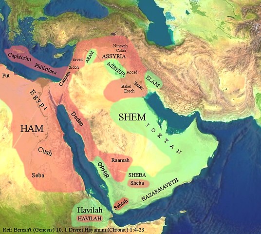
The Middle East through the eyes of the Ancient Israelites. العربية: الشرق الأوسط بعيون الإسرائيليين القدماء. |
| تریخ | |
| سروت |
The background image is based on the satellite image of the Middle East in the public domain from a screenshot from NASA’s globe software World Wind using Blue Marble, Landsat or USGS layer, all of which are in public domain. The geographical location of the place names and color highlights of Ham and Shem are based on the work of 4(four) Israeli Archaeologists: Yohanan Aharoni, Michael Avi-Yonah, Anson F. Rainey, and Ze’ev Safrai, The Macmillan Bible Atlas, Macmillan Publishing: New York, 1993, p. 21. |
| لکھاری | Hkp-avniel 15:50, 22 March 2008 (UTC) |
| دوجے ورژن | العربيَّة |
لائسنس –

|
کاپی کرن، ونڈن تے بدلن دی ایس ڈوکومنٹ لئی اجازت دتی جاندی اے ایہناں GNU Free Documentation License, Version 1.2 شرطاں نال یا مگروں کسے وی چھپے ورین Free Software Foundation توں بنا کسے انویرینٹ سیکشن دے، ناں فرنٹ کور لکھت تے ناں بیک کور لکھت دے۔ لسنس دی اک کاپی سیکشن وچ ہیگی اے جہدا ناں اے GNU Free Documentation License۔ |
- تہانوں کھلھ اے:
- حصہ کرنا – کاپی، ونڈنا تے کم بھیجنا
- فیر رلانا – کم نوں فٹ کرنا
- تھلے دتیاں شرطاں نال:
- کس دے ناں – تسیں لازمی ایس کم دے بناں والے بارے دسو جنج اونے آکھیا اے یا جنج لسنس چ آکھیا گیا ہے۔
- اکو جہا شئیر کرو۔ – اگر تسیں بدلدے یا ایس کم تے بناندے تے بنن والے کم نوں اینج دے لسنس نال ای ونڈو گے۔
فائل دی تریخ
فائل نو اس ویلے دی حالت وچ ویکھن واسطے تاریخ/ویلے تے کلک کرو۔
| تریخ تے ویلہ | نکی مورت | پاسے | ورتن والا | تیپّݨی کرو | |
|---|---|---|---|---|---|
| موجودہ | ۲۰:۵۳, ۲۲ مارچ ۲۰۰۸ | | ۱,۰۰۰ × ۸۹۵ (۸۲۳ کلوبائٹ) | Hkp-avniel | {{Information |Description= |Source= |Date= |Author= |Permission= |other_versions= }} |
| ۱۶:۰۶, ۲۲ مارچ ۲۰۰۸ |  | ۱,۰۰۰ × ۸۹۵ (۸۲۵ کلوبائٹ) | Hkp-avniel | {{Information |Description= The Middle East through the eyes of the Ancient Israelites. |Source= The background image is based on the satellite image of the Middle East in the public domain from a screenshot from NASA’s globe software World Wind using B |
فائل دی ورتوں
تھلے دتے گئے 1 صفحے اس فائل نال جُڑدے نیں
فائل ویاپک ورتوں
ایہہ دوجے وکیاں ایس فائل نوں ورتدے نیں –
- ar.wikipedia.org تے ورتوں
- bs.wikipedia.org تے ورتوں
- ca.wikipedia.org تے ورتوں
- cs.wikipedia.org تے ورتوں
- en.wikipedia.org تے ورتوں
- fi.wikipedia.org تے ورتوں
- fr.wikipedia.org تے ورتوں
- he.wikipedia.org تے ورتوں
- lt.wikipedia.org تے ورتوں
- pt.wikipedia.org تے ورتوں
- ro.wikipedia.org تے ورتوں
- so.wikipedia.org تے ورتوں
- uk.wikipedia.org تے ورتوں
- zh.wikipedia.org تے ورتوں