
فائل:SanJoaquinRiverMap.jpg

ایس وکھالے دا ناپ: ۵۹۸ × ۵۹۹ پکسلز۔ دوجے ریزولوشنز: ۲۴۰ × ۲۴۰ پکسلز | ۴۷۹ × ۴۸۰ پکسلز | ۷۶۷ × ۷۶۸ پکسلز | ۱,۰۹۲ × ۱,۰۹۴ پکسلز ۔
اصل فائل (۱,۰۹۲ × ۱,۰۹۴ پکسلز, فائل حجم: ۱.۲۴ میگابائٹ, MIME type: image/jpeg)
خلاصہ
| تفصیل |
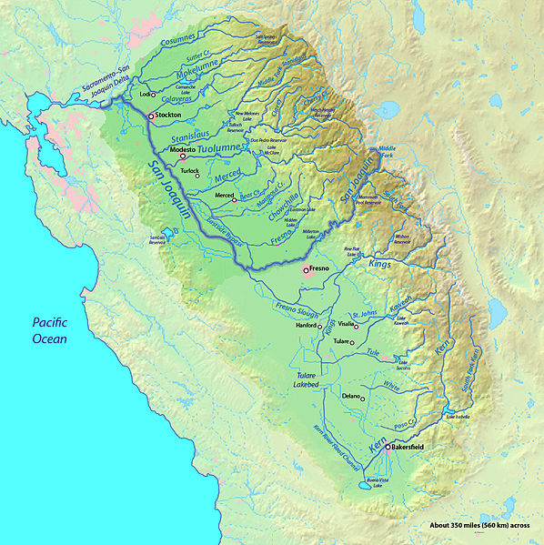
English: Map of the San Joaquin River watershed, which drains most of central inland California into the Pacific |
| تریخ | |
| سروت | Background from http://www2.demis.nl/mapserver/mapper.asp |
| لکھاری | Background layer attributed to DEMIS Mapserver, map created by Shannon1 |
| اجازت (فائل نوں دوبارہ ورتنا) |
Map created from DEMIS Mapserver, which are public domain. |
لائسنس –
میں، اس کم دے کاپیرائٹ دا مالک، اس کم نوں اس لائسنس دے مطابق چھاپدا واں:

|
کاپی کرن، ونڈن تے بدلن دی ایس ڈوکومنٹ لئی اجازت دتی جاندی اے ایہناں GNU Free Documentation License, Version 1.2 شرطاں نال یا مگروں کسے وی چھپے ورین Free Software Foundation توں بنا کسے انویرینٹ سیکشن دے، ناں فرنٹ کور لکھت تے ناں بیک کور لکھت دے۔ لسنس دی اک کاپی سیکشن وچ ہیگی اے جہدا ناں اے GNU Free Documentation License۔ |
This file is licensed under the Creative Commons Attribution-Share Alike 4.0 International, 3.0 Unported, 2.5 Generic, 2.0 Generic and 1.0 Generic license.
- تہانوں کھلھ اے:
- حصہ کرنا – کاپی، ونڈنا تے کم بھیجنا
- فیر رلانا – کم نوں فٹ کرنا
- تھلے دتیاں شرطاں نال:
- کس دے ناں – تسیں لازمی ایس کم دے بناں والے بارے دسو جنج اونے آکھیا اے یا جنج لسنس چ آکھیا گیا ہے۔
- اکو جہا شئیر کرو۔ – اگر تسیں بدلدے یا ایس کم تے بناندے تے بنن والے کم نوں اینج دے لسنس نال ای ونڈو گے۔
تسیں اپنی مرضی دا لائسنس چݨ سکدے اوہ۔
فائل دی تریخ
فائل نو اس ویلے دی حالت وچ ویکھن واسطے تاریخ/ویلے تے کلک کرو۔
| تریخ تے ویلہ | نکی مورت | پاسے | ورتن والا | تیپّݨی کرو | |
|---|---|---|---|---|---|
| موجودہ | ۰۱:۱۴, ۹ ستمبر ۲۰۱۲ | | ۱,۰۹۲ × ۱,۰۹۴ (۱.۲۴ میگابائٹ) | Shannon1 | increased resolution and fixed some river courses in tulare basin |
| ۰۹:۳۱, ۳۱ جنوری ۲۰۱۱ |  | ۹۱۷ × ۷۵۳ (۴۵۴ کلوبائٹ) | Shannon1 | updated, fixed some river paths, added location of dry lakes | |
| ۲۳:۵۶, ۳۰ جنوری ۲۰۱۰ |  | ۱,۲۰۵ × ۹۵۶ (۶۲۳ کلوبائٹ) | Shannon1 | {{Information |Description={{en|1=Map of the San Joaquin River watershed, which drains most of central inland California into the Pacific}} |Source=Background from http://www2.demis.nl/mapserver/mapper.asp |Author=Background layer attributed to DEMIS Map |
فائل دی ورتوں
اس فائل نال جڑیا کوئی صفحہ نئیں۔
فائل ویاپک ورتوں
ایہہ دوجے وکیاں ایس فائل نوں ورتدے نیں –
- en.wikipedia.org تے ورتوں
- es.wikipedia.org تے ورتوں
- hr.wikipedia.org تے ورتوں
- id.wikipedia.org تے ورتوں
- zh.wikipedia.org تے ورتوں