
فائل:Wake Island.png

ایس وکھالے دا ناپ: ۵۹۷ × ۶۰۰ پکسلز۔ دوجے ریزولوشنز: ۲۳۹ × ۲۴۰ پکسلز | ۶۳۱ × ۶۳۴ پکسلز ۔
اصل فائل (۶۳۱ × ۶۳۴ پکسلز, فائل حجم: ۳۰۷ کلوبائٹ, MIME type: image/png)
|
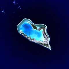
This is an image of a place or building that is listed on the National Register of Historic Places in the United States of America. Its reference number is 85002726. |
Wake Island - NASA NLT Landsat 7 (Visible Color) Satellite Image
| This file is in the public domain in the United States because it was solely created by NASA. NASA copyright policy states that "NASA material is not protected by copyright unless noted". (See Template:PD-USGov, NASA copyright policy page or JPL Image Use Policy.) | ||
 |
Warnings:
|
| Object location | | View this and other nearby images on: OpenStreetMap |
|---|
فائل دی تریخ
فائل نو اس ویلے دی حالت وچ ویکھن واسطے تاریخ/ویلے تے کلک کرو۔
| تریخ تے ویلہ | نکی مورت | پاسے | ورتن والا | تیپّݨی کرو | |
|---|---|---|---|---|---|
| موجودہ | ۲۰:۰۵, ۱۰ اپریل ۲۰۰۵ | | ۶۳۱ × ۶۳۴ (۳۰۷ کلوبائٹ) | Bollar | Wake Island - NASA NLT Landsat 7 (Visible Color) Satellite Image {{PD-USGov-NASA}} |
فائل دی ورتوں
اس فائل نال جڑیا کوئی صفحہ نئیں۔
فائل ویاپک ورتوں
ایہہ دوجے وکیاں ایس فائل نوں ورتدے نیں –
- af.wikipedia.org تے ورتوں
- als.wikipedia.org تے ورتوں
- ast.wikipedia.org تے ورتوں
- cr.wikipedia.org تے ورتوں
- da.wikipedia.org تے ورتوں
- de.wikipedia.org تے ورتوں
- en.wikipedia.org تے ورتوں
- es.wikipedia.org تے ورتوں
- et.wikipedia.org تے ورتوں
- eu.wikipedia.org تے ورتوں
- fi.wikipedia.org تے ورتوں
- frp.wikipedia.org تے ورتوں
- frr.wikipedia.org تے ورتوں
- fr.wikipedia.org تے ورتوں
- gl.wikipedia.org تے ورتوں
- hi.wikipedia.org تے ورتوں
- id.wikipedia.org تے ورتوں
- is.wikipedia.org تے ورتوں
- it.wikipedia.org تے ورتوں
- ja.wikinews.org تے ورتوں
- jv.wikipedia.org تے ورتوں
- ko.wikipedia.org تے ورتوں
- la.wikipedia.org تے ورتوں
- lv.wikipedia.org تے ورتوں
- ms.wikipedia.org تے ورتوں
- no.wikipedia.org تے ورتوں
- pap.wikipedia.org تے ورتوں
- pl.wiktionary.org تے ورتوں
- pt.wikipedia.org تے ورتوں
- ro.wikipedia.org تے ورتوں
ایس فائل دا ویکھو ہور جگت ورتن .