
فائل:Adaie.jpg
اس توں وڈی مورت موجود نہیں۔
Adaie.jpg (۶۵۴ × ۵۹۸ پکسلز, فائل حجم: ۱۵۶ کلوبائٹ, MIME type: image/jpeg)
خلاصہ
| تفصیل |
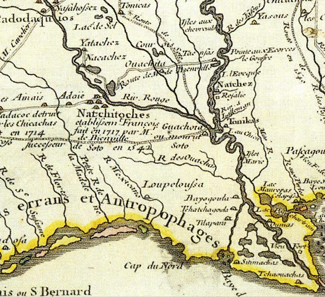
English: Cropped map from a larger 1718 map by Guillaume Delisle. |
|||||||||||||||||||||||
| تریخ | ||||||||||||||||||||||||
| سروت | =Cropped map from a larger 1718 map by Guillaume Delisle. | |||||||||||||||||||||||
| لکھاری |
|
|||||||||||||||||||||||
| اجازت (فائل نوں دوبارہ ورتنا) |
This is public domain and over 100 years old. | |||||||||||||||||||||||

لائسنس –
|
This is a faithful photographic reproduction of a two-dimensional, public domain work of art. The work of art itself is in the public domain for the following reason:
The official position taken by the Wikimedia Foundation is that "faithful reproductions of two-dimensional public domain works of art are public domain".
This photographic reproduction is therefore also considered to be in the public domain in the United States. In other jurisdictions, re-use of this content may be restricted; see Reuse of PD-Art photographs for details. | ||||
فائل دی تریخ
فائل نو اس ویلے دی حالت وچ ویکھن واسطے تاریخ/ویلے تے کلک کرو۔
| تریخ تے ویلہ | نکی مورت | پاسے | ورتن والا | تیپّݨی کرو | |
|---|---|---|---|---|---|
| موجودہ | ۱۹:۱۷, ۴ جولائی ۲۰۱۲ | | ۶۵۴ × ۵۹۸ (۱۵۶ کلوبائٹ) | Elvisor | {{BotMoveToCommons|en.wikipedia|year={{subst:CURRENTYEAR}}|month={{subst:CURRENTMONTHNAME}}|day={{subst:CURRENTDAY}}}} {{Information |Description={{en|I cropped this map from a larger 1718 map by Guillaume Delisle. This is public domain and over 100... |
فائل دی ورتوں
تھلے دتے گئے 1 صفحے اس فائل نال جُڑدے نیں
فائل ویاپک ورتوں
ایہہ دوجے وکیاں ایس فائل نوں ورتدے نیں –
- de.wikipedia.org تے ورتوں
- en.wikipedia.org تے ورتوں
- es.wikipedia.org تے ورتوں
- it.wikipedia.org تے ورتوں
- ur.wikipedia.org تے ورتوں
- www.wikidata.org تے ورتوں