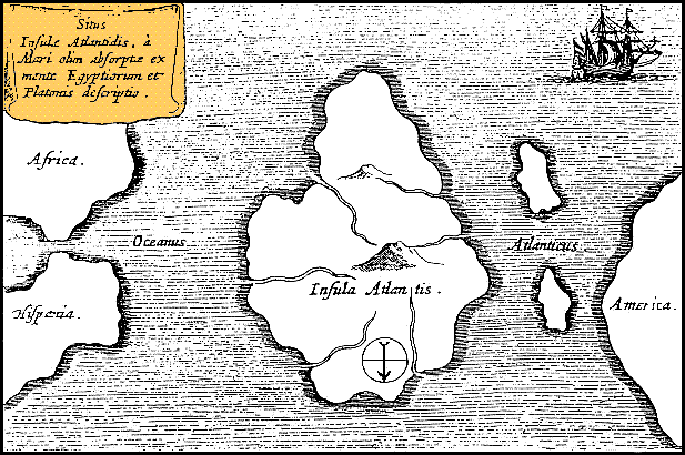
فائل:Athanasius Kircher's Atlantis.gif
Athanasius_Kircher's_Atlantis.gif (۶۱۷ × ۴۱۰ پکسلز, فائل حجم: ۳۶ کلوبائٹ, MIME type: image/gif)
فائل دی تریخ
فائل نو اس ویلے دی حالت وچ ویکھن واسطے تاریخ/ویلے تے کلک کرو۔
| تریخ تے ویلہ | نکی مورت | پاسے | ورتن والا | تیپّݨی کرو | |
|---|---|---|---|---|---|
| موجودہ | ۱۷:۳۹, ۱۵ اکتوبر ۲۰۱۳ |  | ۶۱۷ × ۴۱۰ (۳۶ کلوبائٹ) | AnonMoos | Reverted to version as of 01:05, 29 December 2005 -- rotating image turned text upside down |
| ۱۷:۳۷, ۱۵ اکتوبر ۲۰۱۳ |  | ۶۱۷ × ۴۱۰ (۳۶ کلوبائٹ) | Rotatebot | Bot: Image rotated by 180° | |
| ۰۶:۰۵, ۲۹ دسمبر ۲۰۰۵ |  | ۶۱۷ × ۴۱۰ (۳۶ کلوبائٹ) | Comae | Tomado de en.wikipedia, donde dice: Author: Athanasius_Kircher's Map of Atlantis (c.1669) Source: http://atlants.haktanir.org/ch3.html This image is in the public domain because its copyright has expired in the United States and those countries with a c |
فائل دی ورتوں
تھلے دتے گئے 1 صفحے اس فائل نال جُڑدے نیں
فائل ویاپک ورتوں
ایہہ دوجے وکیاں ایس فائل نوں ورتدے نیں –
- af.wikipedia.org تے ورتوں
- an.wikipedia.org تے ورتوں
- ar.wikipedia.org تے ورتوں
- ar.wikiversity.org تے ورتوں
- ast.wikipedia.org تے ورتوں
- az.wikipedia.org تے ورتوں
- be-tarask.wikipedia.org تے ورتوں
- beta.wikiversity.org تے ورتوں
- be.wikipedia.org تے ورتوں
- bg.wikipedia.org تے ورتوں
- bn.wikipedia.org تے ورتوں
- ca.wikipedia.org تے ورتوں
- ceb.wikipedia.org تے ورتوں
- cs.wikipedia.org تے ورتوں
- de.wikipedia.org تے ورتوں
- diq.wikipedia.org تے ورتوں
- el.wikipedia.org تے ورتوں
- en.wikipedia.org تے ورتوں
- en.wikibooks.org تے ورتوں
- en.wikiversity.org تے ورتوں
- en.wikivoyage.org تے ورتوں
- eo.wikipedia.org تے ورتوں
- es.wikipedia.org تے ورتوں
- es.wikibooks.org تے ورتوں
- et.wikipedia.org تے ورتوں
- eu.wikipedia.org تے ورتوں
- fi.wikibooks.org تے ورتوں
- fr.wiktionary.org تے ورتوں
- fy.wikipedia.org تے ورتوں
ایس فائل دا ویکھو ہور جگت ورتن .


