
فائل:Belgrade pashaluk.png
ایس وکھالے دا ناپ: ۷۷۲ × ۵۹۹ پکسلز۔ دوجے ریزولوشنز: ۳۰۹ × ۲۴۰ پکسلز | ۶۱۸ × ۴۸۰ پکسلز | ۸۶۳ × ۶۷۰ پکسلز ۔
اصل فائل (۸۶۳ × ۶۷۰ پکسلز, فائل حجم: ۶۹ کلوبائٹ, MIME type: image/png)
خلاصہ
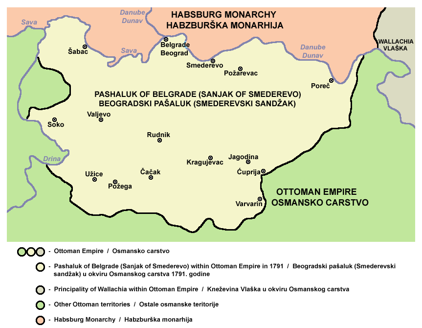
- English: Pashaluk of Belgrade (Sanjak of Smederevo) within Ottoman Empire in 1791.
- Serbian: Beogradski pašaluk (Smederevski sandžak) u okviru Osmanskog carstva 1791. godine.
- Other version: Macedonian version
Source and licence
Self-made map created by PANONIAN
| اس کم نوں لوکاں لئی ایدے لکھاریPANONIAN نے دے دتا اے، اے سارے جگ واسطے لاگو اے۔ کج ملکاں چ قانونی طور تے اے ممکن نئیں اے؛ اگر انج ای اے ے: |

|
This map has been uploaded by Electionworld from en.wikipedia.org to enable the |
References
- http://terkepek.adatbank.transindex.ro/kepek/netre/51.gif
- http://www.rodnikraj.eu/index_htm_files/255.png[dead link]
- Školski istorijski atlas, Zavod za izdavanje udžbenika SR Srbije, Beograd, 1970.
- Istorijski atlas, Geokarta, Beograd, 1999.
- Povijesni atlas, Učila - Zagreb, Zagreb, 1971.
- Denis Šehić - Demir Šehić, Istorijski atlas sveta, Beograd, 2007.
- The Times History of Europe, Times Books, London, 2002.
فائل دی تریخ
فائل نو اس ویلے دی حالت وچ ویکھن واسطے تاریخ/ویلے تے کلک کرو۔
| تریخ تے ویلہ | نکی مورت | پاسے | ورتن والا | تیپّݨی کرو | |
|---|---|---|---|---|---|
| موجودہ | ۰۱:۱۰, ۲۲ ستمبر ۲۰۱۳ | | ۸۶۳ × ۶۷۰ (۶۹ کلوبائٹ) | PANONIAN | aesthetics |
| ۰۳:۱۳, ۱۵ اکتوبر ۲۰۱۲ |  | ۸۶۳ × ۶۶۷ (۶۹ کلوبائٹ) | PANONIAN | minor corrections | |
| ۰۳:۲۶, ۱۴ جنوری ۲۰۱۱ |  | ۸۶۵ × ۶۶۷ (۶۹ کلوبائٹ) | PANONIAN | another attempt of solving thumbnail problem | |
| ۲۲:۰۵, ۱۳ جنوری ۲۰۱۱ |  | ۸۶۵ × ۶۶۷ (۶۹ کلوبائٹ) | PANONIAN | Reverted to version as of 16:56, 13 January 2011 - trying again to fix problem. why this file is generating thumbnail from older version? | |
| ۲۱:۵۹, ۱۳ جنوری ۲۰۱۱ |  | ۸۶۵ × ۶۶۷ (۶۹ کلوبائٹ) | PANONIAN | Reverted to version as of 16:56, 13 January 2011 - fixing thumbnail problem | |
| ۲۱:۵۸, ۱۳ جنوری ۲۰۱۱ |  | ۸۶۵ × ۶۶۷ (۶۹ کلوبائٹ) | PANONIAN | Reverted to version as of 16:53, 13 January 2011 - fixing thumbnail problem | |
| ۲۱:۵۶, ۱۳ جنوری ۲۰۱۱ |  | ۸۶۵ × ۶۶۷ (۶۹ کلوبائٹ) | PANONIAN | Reverted to version as of 16:53, 13 January 2011 - fixing thumbnail problem | |
| ۲۱:۵۴, ۱۳ جنوری ۲۰۱۱ |  | ۷۵۶ × ۵۵۲ (۱۶ کلوبائٹ) | PANONIAN | Reverted to version as of 21:43, 21 December 2006 - fixing thumbnail problem | |
| ۲۱:۵۳, ۱۳ جنوری ۲۰۱۱ |  | ۸۶۵ × ۶۶۷ (۶۹ کلوبائٹ) | PANONIAN | improved version | |
| ۰۲:۴۳, ۲۲ دسمبر ۲۰۰۶ |  | ۷۵۶ × ۵۵۲ (۱۶ کلوبائٹ) | Electionworld | {{ew|en|PANONIAN}} Self-made map by PANONIAN {{PD-user|PANONIAN}} Category:Maps of Serbia |
فائل دی ورتوں
تھلے دتے گئے 1 صفحے اس فائل نال جُڑدے نیں
فائل ویاپک ورتوں
ایہہ دوجے وکیاں ایس فائل نوں ورتدے نیں –
- be.wikipedia.org تے ورتوں
- ca.wikipedia.org تے ورتوں
- cs.wikipedia.org تے ورتوں
- de.wikipedia.org تے ورتوں
- el.wikipedia.org تے ورتوں
- en.wikipedia.org تے ورتوں
- fr.wikipedia.org تے ورتوں
- gl.wikipedia.org تے ورتوں
- hr.wikipedia.org تے ورتوں
- id.wikipedia.org تے ورتوں
- it.wikipedia.org تے ورتوں
- mk.wikipedia.org تے ورتوں
- pl.wikipedia.org تے ورتوں
- pt.wikipedia.org تے ورتوں
- ro.wikipedia.org تے ورتوں
- ru.wikipedia.org تے ورتوں
- sh.wikipedia.org تے ورتوں
- sq.wikipedia.org تے ورتوں
- sr.wikipedia.org تے ورتوں
- th.wikipedia.org تے ورتوں
- tr.wikipedia.org تے ورتوں
- uk.wikipedia.org تے ورتوں
- ur.wikipedia.org تے ورتوں
- zh.wikipedia.org تے ورتوں