
فائل:East Midlands counties 2009 map.svg

Size of this PNG preview of this SVG file: ۵۰۵ × ۶۰۰ پکسلز. دوجے ریزولوشنز: ۲۰۲ × ۲۴۰ پکسلز | ۴۰۴ × ۴۸۰ پکسلز | ۶۴۷ × ۷۶۸ پکسلز | ۸۶۲ × ۱,۰۲۴ پکسلز | ۱,۷۲۵ × ۲,۰۴۸ پکسلز | ۱,۰۹۹ × ۱,۳۰۵ پکسلز ۔
اصل فائل (ایس وی جی فائل، پکسل:۱,۰۹۹ × ۱,۳۰۵، فائل سائز: ۱.۶۶ میگابائٹ)
خلاصہ
| تفصیل |
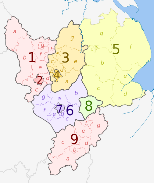
English: Map of the East Midlands region of England, showing its counties and administrative districts in 2009. The county colours are the same as those in File:English metropolitan and non-metropolitan counties 2009.svg.
See File:East Midlands counties 2021 map.svg for the counties since 1 April 2021. Equirectangular map projection on WGS 84 datum, with N/S stretched 165% Geographic limits:
|
| تریخ | (UTC) |
| سروت |
This file was derived from: |
| لکھاری |
|
| دوجے ورژن |
|


| Map | Ceremonial county | Shire county /unitary |
Districts |
|---|---|---|---|
 |
Derbyshire | 1. Derbyshire | a) High Peak, b) Derbyshire Dales, c) South Derbyshire, d) Erewash, e) Amber Valley, f) North East Derbyshire, g) Chesterfield, h) Bolsover |
| 2. Derby U.A. | |||
| Nottinghamshire | 3. Nottinghamshire | a) Rushcliffe, b) Broxtowe, c) Ashfield, d) Gedling, e) Newark and Sherwood, f) Mansfield, g) Bassetlaw | |
| 4. Nottingham U.A. | |||
| Lincolnshire (part only) |
5. Lincolnshire | a) Lincoln, b) North Kesteven, c) South Kesteven, d) South Holland, e) Boston, f) East Lindsey, g) West Lindsey | |
| Leicestershire | 6. Leicestershire | a) Charnwood, b) Melton, c) Harborough, d) Oadby and Wigston, e) Blaby, f) Hinckley and Bosworth, g) North West Leicestershire | |
| 7. Leicester U.A. | |||
| 8. Rutland | |||
| 9. Northamptonshire | a) South Northamptonshire, b) Northampton, c) Daventry, d) Wellingborough, e) Kettering, f) Corby, g) East Northamptonshire | ||
لائسنس –
ایس فائل نوں کریٹو کامنز Attribution 2.5 پولینڈ لائسنس دتا گیا.
کس دے ناں: Dr Greg and Nilfanion. Contains Ordnance Survey data © Crown copyright and database right 2011
- تہانوں کھلھ اے:
- حصہ کرنا – کاپی، ونڈنا تے کم بھیجنا
- فیر رلانا – کم نوں فٹ کرنا
- تھلے دتیاں شرطاں نال:
- کس دے ناں – تسیں لازمی ایس کم دے بناں والے بارے دسو جنج اونے آکھیا اے یا جنج لسنس چ آکھیا گیا ہے۔
- اکو جہا شئیر کرو۔ – اگر تسیں بدلدے یا ایس کم تے بناندے تے بنن والے کم نوں اینج دے لسنس نال ای ونڈو گے۔
پہلا اپلوڈ دا ریکارڈ
This image is a derivative work of the following images:
- File:East_Midlands_districts_2011_map.svg licensed with Cc-by-sa-3.0, GFDL
- 2011-05-01T18:55:02Z Nilfanion 1099x1305 (1687648 Bytes) == Summary == {{Information |Description=Map of the [[w:East Midlands|East Midlands]] region showing the administrative districts. Equirectangular map projection on WGS 84 datum, with N/S stretched 165% Geographic limits: *
- File:English_ceremonial_counties_2010.svg licensed with Cc-by-sa-3.0, GFDL
- 2010-11-23T16:39:55Z Nilfanion 1108x1345 (308868 Bytes) thicker lines
- 2010-11-23T16:20:19Z Nilfanion 1108x1345 (301520 Bytes) tweaks
- 2010-10-26T20:34:20Z Nilfanion 817x990 (1391832 Bytes) {{Information |Description=Map showing the [[w:ceremonial counties of England]] including the City of London, in 2010. Equirectangular map projection on WGS 84 datum, with N/S stretched 170% Geographic limits: *West: 6.75W
Uploaded with derivativeFX
فائل دی تریخ
فائل نو اس ویلے دی حالت وچ ویکھن واسطے تاریخ/ویلے تے کلک کرو۔
| تریخ تے ویلہ | نکی مورت | پاسے | ورتن والا | تیپّݨی کرو | |
|---|---|---|---|---|---|
| موجودہ | ۰۲:۵۴, ۲ مئی ۲۰۱۲ | | ۱,۰۹۹ × ۱,۳۰۵ (۱.۶۶ میگابائٹ) | Dr Greg | == {{int:filedesc}} == {{Information |Description={{en|Map of the East Midlands region of England, showing its counties and administrative districts. The county colours are the same as those in [[:File:English metropolitan and non-m... |
فائل دی ورتوں
تھلے دتے گئے 1 صفحے اس فائل نال جُڑدے نیں
فائل ویاپک ورتوں
ایہہ دوجے وکیاں ایس فائل نوں ورتدے نیں –
- ar.wikipedia.org تے ورتوں
- de.wikivoyage.org تے ورتوں
- en.wikipedia.org تے ورتوں
- fa.wikipedia.org تے ورتوں
- frr.wikipedia.org تے ورتوں
- fr.wikipedia.org تے ورتوں
- hr.wikipedia.org تے ورتوں
- mr.wikipedia.org تے ورتوں
- pl.wikipedia.org تے ورتوں
- pt.wikipedia.org تے ورتوں
- th.wikipedia.org تے ورتوں
- ur.wikipedia.org تے ورتوں
- vi.wikipedia.org تے ورتوں
- vls.wikipedia.org تے ورتوں
- zh-yue.wikipedia.org تے ورتوں