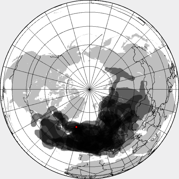
فائل:Eyjafjallajökull volcanic ash composite.png
Appearance

ایس وکھالے دا ناپ: ۶۰۰ × ۶۰۰ پکسلز۔ دوجے ریزولوشنز: ۲۴۰ × ۲۴۰ پکسلز | ۴۸۰ × ۴۸۰ پکسلز | ۷۲۶ × ۷۲۶ پکسلز ۔
اصل فائل (۷۲۶ × ۷۲۶ پکسلز, فائل حجم: ۹۵ کلوبائٹ, MIME type: image/png)
فائل دی تریخ
فائل نو اس ویلے دی حالت وچ ویکھن واسطے تاریخ/ویلے تے کلک کرو۔
| تریخ تے ویلہ | نکی مورت | پاسے | ورتن والا | تیپّݨی کرو | |
|---|---|---|---|---|---|
| موجودہ | ۱۹:۵۳, ۲۷ اپریل ۲۰۱۰ |  | ۷۲۶ × ۷۲۶ (۹۵ کلوبائٹ) | Cogiati | added 17 april |
| ۱۹:۰۹, ۲۶ اپریل ۲۰۱۰ |  | ۷۲۶ × ۷۲۶ (۹۳ کلوبائٹ) | Cogiati | added 18 april | |
| ۱۲:۳۲, ۲۶ اپریل ۲۰۱۰ |  | ۷۲۶ × ۷۲۶ (۹۲ کلوبائٹ) | Cogiati | added 25 April | |
| ۲۱:۰۰, ۲۵ اپریل ۲۰۱۰ |  | ۷۲۶ × ۷۲۶ (۹۱ کلوبائٹ) | Cogiati | added 16 april | |
| ۰۶:۵۶, ۲۵ اپریل ۲۰۱۰ |  | ۷۲۶ × ۷۲۶ (۹۰ کلوبائٹ) | Cogiati | added 20 april | |
| ۰۶:۳۲, ۲۵ اپریل ۲۰۱۰ |  | ۷۲۶ × ۷۲۶ (۸۸ کلوبائٹ) | Cogiati | {{Information |Description=This is a composite map showing the position of the Icelandinc volcanic ash cloud that closed European air space in different days. Based on maps found at http://www.metoffice.gov.uk/aviation/vaac/vaacuk_vag.html Days included: |
فائل دی ورتوں
تھلے دتے گئے 1 صفحے اس فائل نال جُڑدے نیں
فائل ویاپک ورتوں
ایہہ دوجے وکیاں ایس فائل نوں ورتدے نیں –
- ca.wikipedia.org تے ورتوں
- da.wikipedia.org تے ورتوں
- de.wikipedia.org تے ورتوں
- en.wikipedia.org تے ورتوں
- es.wikipedia.org تے ورتوں
- eu.wikipedia.org تے ورتوں
- fi.wikipedia.org تے ورتوں
- hu.wikipedia.org تے ورتوں
- it.wikipedia.org تے ورتوں
- ja.wikipedia.org تے ورتوں
- pt.wikipedia.org تے ورتوں
- ru.wikipedia.org تے ورتوں
- th.wikipedia.org تے ورتوں
- ur.wikipedia.org تے ورتوں
- vi.wikipedia.org تے ورتوں
- zh.wikipedia.org تے ورتوں
