
فائل:French Algeria evolution 1830-1962 map-fr.svg

Size of this PNG preview of this SVG file: ۶۰۴ × ۶۰۰ پکسلز. دوجے ریزولوشنز: ۲۴۲ × ۲۴۰ پکسلز | ۴۸۳ × ۴۸۰ پکسلز | ۷۷۳ × ۷۶۸ پکسلز | ۱,۰۳۱ × ۱,۰۲۴ پکسلز | ۲,۰۶۲ × ۲,۰۴۸ پکسلز | ۱,۲۸۷ × ۱,۲۷۸ پکسلز ۔
اصل فائل (ایس وی جی فائل، پکسل:۱,۲۸۷ × ۱,۲۷۸، فائل سائز: ۱.۸۶ میگابائٹ)
خلاصہ
| تفصیل |
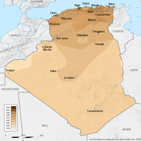
English: French Algeria evolution map, from 1830 to 1962.
Français : Carte montrant l'évolution territoriale de l'Algérie française, de 1830 à 1962.
|
| تریخ | (UTC) |
| سروت |
English:
Français :
|
| لکھاری | Sémhur |
| دوجے ورژن |
Derivative works of this file: French Algeria evolution 1830-1962 map-es.svg |
| کس دے ناں (required by the license) | © Sémhur / Wikimedia Commons / |
| SVG genesis |
| Camera location | | View this and other nearby images on: OpenStreetMap |
|---|
لائسنس –
میں، اس کم دے کاپیرائٹ دا مالک، اس کم نوں اس لائسنس دے مطابق چھاپدا واں:
| کاپی حق چھڈیا: آرٹ دا ایہ کم کھلا اے؛ تسیں اینوں ونڈ سکدے او یا بدل سکدے او Free Art License دیاں شرطاں نال۔ تسیں ایدے لسنس دی اک ادھارن Copyleft Attitude site تے Copyleft Attitude site تے ہور سائیٹاں تے لب سکدے او |
This file is licensed under the Creative Commons Attribution-Share Alike 4.0 International, 3.0 Unported, 2.5 Generic, 2.0 Generic and 1.0 Generic license.
- تہانوں کھلھ اے:
- حصہ کرنا – کاپی، ونڈنا تے کم بھیجنا
- فیر رلانا – کم نوں فٹ کرنا
- تھلے دتیاں شرطاں نال:
- کس دے ناں – تسیں لازمی ایس کم دے بناں والے بارے دسو جنج اونے آکھیا اے یا جنج لسنس چ آکھیا گیا ہے۔
- اکو جہا شئیر کرو۔ – اگر تسیں بدلدے یا ایس کم تے بناندے تے بنن والے کم نوں اینج دے لسنس نال ای ونڈو گے۔
تسیں اپنی مرضی دا لائسنس چݨ سکدے اوہ۔
پہلا اپلوڈ دا ریکارڈ
This image is a derivative work of the following images:
- File:Algeria_location_map.svg licensed with Cc-by-sa-3.0, GFDL
- 2009-11-17T12:51:26Z Sting 1287x1278 (372657 Bytes) == {{int:filedesc}} == {{Location|28|19|00|N|1|39|00|E|scale:8000000}} {{Information |Description={{en|Blank administrative map of [[:en:Algeria|Algeria]], for geo-location purposes.}} {{fr|Carte administrative vierge de l'[
Uploaded with derivativeFX
فائل دی تریخ
فائل نو اس ویلے دی حالت وچ ویکھن واسطے تاریخ/ویلے تے کلک کرو۔
| تریخ تے ویلہ | نکی مورت | پاسے | ورتن والا | تیپّݨی کرو | |
|---|---|---|---|---|---|
| موجودہ | ۰۰:۳۴, ۲۳ مئی ۲۰۱۴ | | ۱,۲۸۷ × ۱,۲۷۸ (۱.۸۶ میگابائٹ) | Sémhur | Valid SVG |
| ۲۳:۵۷, ۲۹ ستمبر ۲۰۱۲ |  | ۱,۲۸۷ × ۱,۲۷۸ (۱.۸۶ میگابائٹ) | Sémhur | == {{int:filedesc}} == {{Information |Description={{Multilingual description |en= en:French Algeria evolution map, from 1830 to 1962. |fr= Carte de l'fr:Algérie française, de 1830 à 1962. }} <br/> Scale: 1:6,800,000 (precision: 1,700 m)... |
فائل دی ورتوں
تھلے دتے گئے 1 صفحے اس فائل نال جُڑدے نیں
فائل ویاپک ورتوں
ایہہ دوجے وکیاں ایس فائل نوں ورتدے نیں –
- ast.wikipedia.org تے ورتوں
- bg.wikipedia.org تے ورتوں
- ca.wikipedia.org تے ورتوں
- da.wikipedia.org تے ورتوں
- de.wikipedia.org تے ورتوں
- en.wikipedia.org تے ورتوں
- eu.wikipedia.org تے ورتوں
- fa.wikipedia.org تے ورتوں
- fi.wikipedia.org تے ورتوں
- fr.wikipedia.org تے ورتوں
- ga.wikipedia.org تے ورتوں
- hy.wikipedia.org تے ورتوں
- id.wikipedia.org تے ورتوں
- it.wikipedia.org تے ورتوں
- ja.wikipedia.org تے ورتوں
- ka.wikipedia.org تے ورتوں
- ko.wikipedia.org تے ورتوں
- lt.wikipedia.org تے ورتوں
- lv.wikipedia.org تے ورتوں
- mk.wikipedia.org تے ورتوں
- ms.wikipedia.org تے ورتوں
- mt.wikipedia.org تے ورتوں
- nl.wikipedia.org تے ورتوں
- pl.wikipedia.org تے ورتوں
- pt.wikipedia.org تے ورتوں
- ro.wikipedia.org تے ورتوں
- ru.wikipedia.org تے ورتوں
ایس فائل دا ویکھو ہور جگت ورتن .