
فائل:Heard Island.jpg

ایس وکھالے دا ناپ: ۸۰۰ × ۴۱۳ پکسلز۔ دوجے ریزولوشنز: ۳۲۰ × ۱۶۵ پکسلز | ۶۴۰ × ۳۳۱ پکسلز | ۱,۲۸۰ × ۶۶۱ پکسلز ۔
اصل فائل (۱,۲۸۰ × ۶۶۱ پکسلز, فائل حجم: ۶۰ کلوبائٹ, MIME type: image/jpeg)
خلاصہ
| تفصیل |
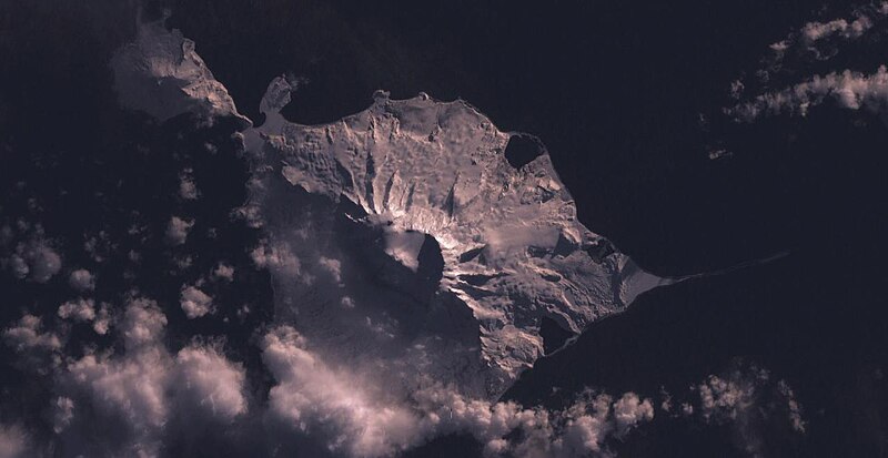
English: Heard Island |
| تریخ | ۳ فروری ۲۰۰۵ (upload date) |
| سروت | Satellite imagery taken by screenshot from NASA World Wind software |
| لکھاری | NASA |
| Object location | | View this and other nearby images on: OpenStreetMap |
|---|
لائسنس –
| This image is in the public domain because it is a screenshot from NASA’s globe software World Wind using a public domain layer, such as Blue Marble, MODIS, Landsat, SRTM, USGS or GLOBE.
|
 |
فائل دی تریخ
فائل نو اس ویلے دی حالت وچ ویکھن واسطے تاریخ/ویلے تے کلک کرو۔
| تریخ تے ویلہ | نکی مورت | پاسے | ورتن والا | تیپّݨی کرو | |
|---|---|---|---|---|---|
| موجودہ | ۱۰:۴۰, ۳ فروری ۲۰۰۵ | | ۱,۲۸۰ × ۶۶۱ (۶۰ کلوبائٹ) | Dysprosia~commonswiki | Heard Island, from NASA World Wind, {{PD-USGov-NASA}}, worldwind://goto/world=Earth&lat=-53.1084289550781&lon=73.5561141967773&view=0.609335660934448 |
فائل دی ورتوں
تھلے دتے گئے 1 صفحے اس فائل نال جُڑدے نیں
فائل ویاپک ورتوں
ایہہ دوجے وکیاں ایس فائل نوں ورتدے نیں –
- af.wikipedia.org تے ورتوں
- ar.wikipedia.org تے ورتوں
- ast.wikipedia.org تے ورتوں
- az.wikipedia.org تے ورتوں
- be.wikipedia.org تے ورتوں
- ca.wikipedia.org تے ورتوں
- ceb.wikipedia.org تے ورتوں
- ckb.wikipedia.org تے ورتوں
- cs.wikipedia.org تے ورتوں
- cy.wikipedia.org تے ورتوں
- de.wikipedia.org تے ورتوں
- de.wikivoyage.org تے ورتوں
- en.wikipedia.org تے ورتوں
- en.wikivoyage.org تے ورتوں
- eo.wikipedia.org تے ورتوں
- es.wikipedia.org تے ورتوں
- fa.wikipedia.org تے ورتوں
- fi.wikipedia.org تے ورتوں
- frr.wikipedia.org تے ورتوں
- fr.wikipedia.org تے ورتوں
- fr.wikivoyage.org تے ورتوں
- fy.wikipedia.org تے ورتوں
- gl.wikipedia.org تے ورتوں
- he.wikipedia.org تے ورتوں
- he.wikivoyage.org تے ورتوں
- hr.wikipedia.org تے ورتوں
- hu.wikipedia.org تے ورتوں
- id.wikipedia.org تے ورتوں
ایس فائل دا ویکھو ہور جگت ورتن .