
فائل:ISS-20 Caribbean island of Hispaniola from the ISS.jpg
ایس وکھالے دا ناپ: ۸۰۰ × ۵۳۲ پکسلز۔ دوجے ریزولوشنز: ۳۲۰ × ۲۱۳ پکسلز | ۶۴۰ × ۴۲۶ پکسلز | ۱,۰۲۴ × ۶۸۱ پکسلز | ۱,۲۸۰ × ۸۵۲ پکسلز | ۲,۵۶۰ × ۱,۷۰۳ پکسلز | ۴,۲۵۶ × ۲,۸۳۲ پکسلز ۔
اصل فائل (۴,۲۵۶ × ۲,۸۳۲ پکسلز, فائل حجم: ۱.۱۷ میگابائٹ, MIME type: image/jpeg)
خلاصہ
| تفصیل |
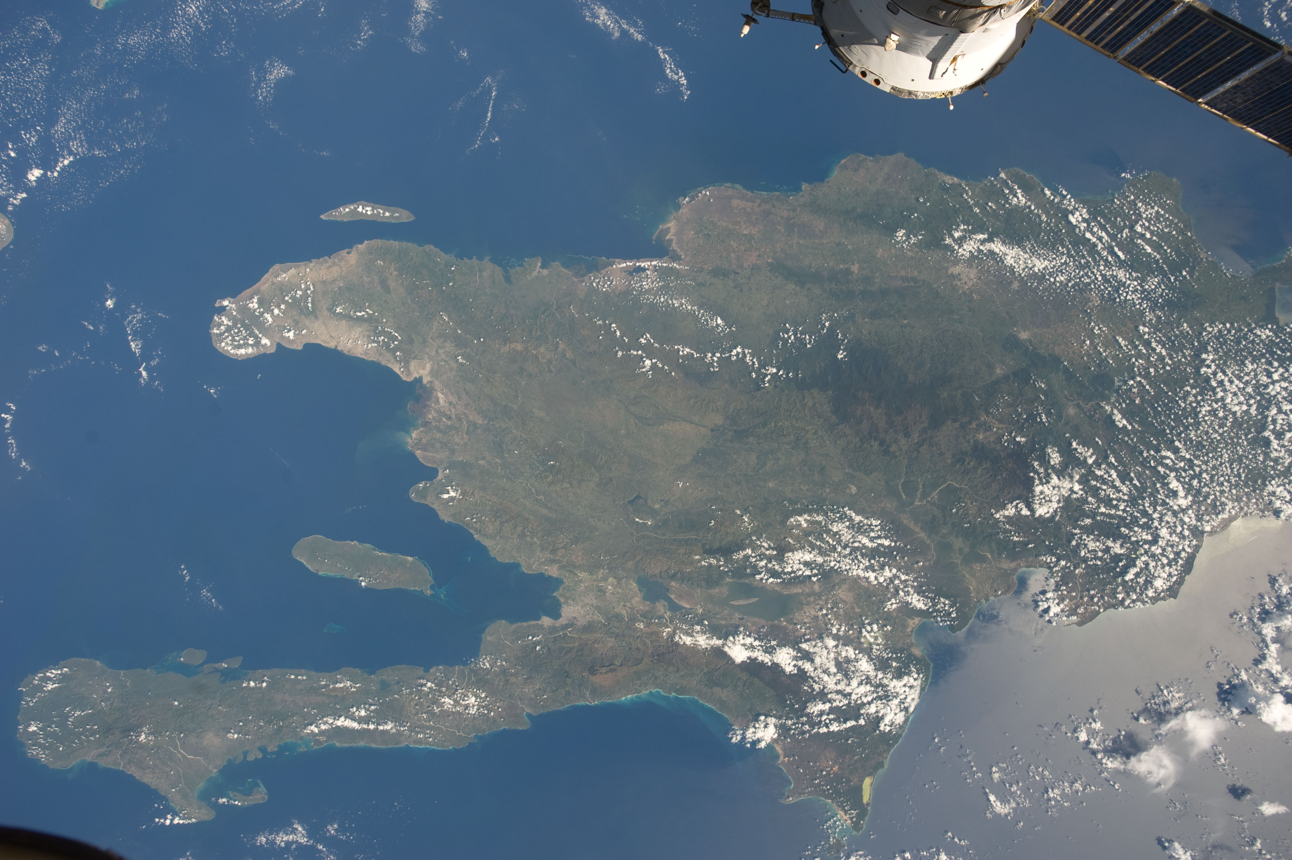
English: A view of the Caribbean island of Hispaniola from the International Space Station. This island is comprised of Haiti (in the center left of the image) and the Dominican Republic and is part of the Greater Antilles island chain which lies along the geological border of the North America Plate and the Caribbean Plate. A major fault line in the region, Enriquillo-Plantain Garden Fault, runs along the longer peninsula, in the foreground, and just south of Port-au-Prince. Part of a docked Russian spacecraft can be seen in the foreground. The epicenter of the disastrous 2010 earthquake occurred near this fault. This image was taken by the Expedition 20 crew on the International Space Station on Sept. 28, 2009 using a 25 mm lens setting. |
| تریخ | |
| سروت | http://spaceflight.nasa.gov/gallery/images/station/crew-20/html/iss020e043301.html |
| لکھاری | NASA/Expedition 20 crew |
| دوجے ورژن |
This image or video was catalogued by Johnson Space Center of the United States National Aeronautics and Space Administration (NASA) under Photo ID: ISS020-E-043301. This tag does not indicate the copyright status of the attached work. A normal copyright tag is still required. See Commons:Licensing. Other languages:
|
لائسنس –
| This file is in the public domain in the United States because it was solely created by NASA. NASA copyright policy states that "NASA material is not protected by copyright unless noted". (See Template:PD-USGov, NASA copyright policy page or JPL Image Use Policy.) | ||
 |
Warnings:
|
فائل دی تریخ
فائل نو اس ویلے دی حالت وچ ویکھن واسطے تاریخ/ویلے تے کلک کرو۔
| تریخ تے ویلہ | نکی مورت | پاسے | ورتن والا | تیپّݨی کرو | |
|---|---|---|---|---|---|
| موجودہ | ۰۱:۱۸, ۲۳ جون ۲۰۱۲ | | ۴,۲۵۶ × ۲,۸۳۲ (۱.۱۷ میگابائٹ) | Ras67 | {{Information |Description={{en|1=A view of the Caribbean island of Hispaniola from the International Space Station. This island is comprised of Haiti (in the center left of the image) and the Dominican Republic and is part of the Greater Antilles isla... |
فائل دی ورتوں
تھلے دتے گئے 1 صفحے اس فائل نال جُڑدے نیں
فائل ویاپک ورتوں
ایہہ دوجے وکیاں ایس فائل نوں ورتدے نیں –
- ar.wikipedia.org تے ورتوں
- ast.wikipedia.org تے ورتوں
- az.wikipedia.org تے ورتوں
- ba.wikipedia.org تے ورتوں
- ca.wikipedia.org تے ورتوں
- ceb.wikipedia.org تے ورتوں
- cy.wikipedia.org تے ورتوں
- de.wikipedia.org تے ورتوں
- es.wikipedia.org تے ورتوں
- eu.wikipedia.org تے ورتوں
- fi.wiktionary.org تے ورتوں
- fr.wikivoyage.org تے ورتوں
- ga.wikipedia.org تے ورتوں
- hsb.wikipedia.org تے ورتوں
- ht.wikipedia.org تے ورتوں
- hy.wikipedia.org تے ورتوں
- ia.wikipedia.org تے ورتوں
- lb.wikipedia.org تے ورتوں
- no.wikipedia.org تے ورتوں
- pap.wikipedia.org تے ورتوں
- pl.wikipedia.org تے ورتوں
- ro.wikipedia.org تے ورتوں
- sv.wikipedia.org تے ورتوں
- tg.wikipedia.org تے ورتوں
- uk.wikipedia.org تے ورتوں
- uz.wikipedia.org تے ورتوں
- vec.wikipedia.org تے ورتوں
- www.wikidata.org تے ورتوں