
فائل:Japan Relief Map of Land and Seabed.png
ایس وکھالے دا ناپ: ۷۲۷ × ۵۹۹ پکسلز۔ دوجے ریزولوشنز: ۲۹۱ × ۲۴۰ پکسلز | ۵۸۲ × ۴۸۰ پکسلز | ۹۳۲ × ۷۶۸ پکسلز | ۱,۲۴۲ × ۱,۰۲۴ پکسلز | ۲,۱۱۷ × ۱,۷۴۵ پکسلز ۔
اصل فائل (۲,۱۱۷ × ۱,۷۴۵ پکسلز, فائل حجم: ۷.۴۷ میگابائٹ, MIME type: image/png)
خلاصہ
| تفصیل |
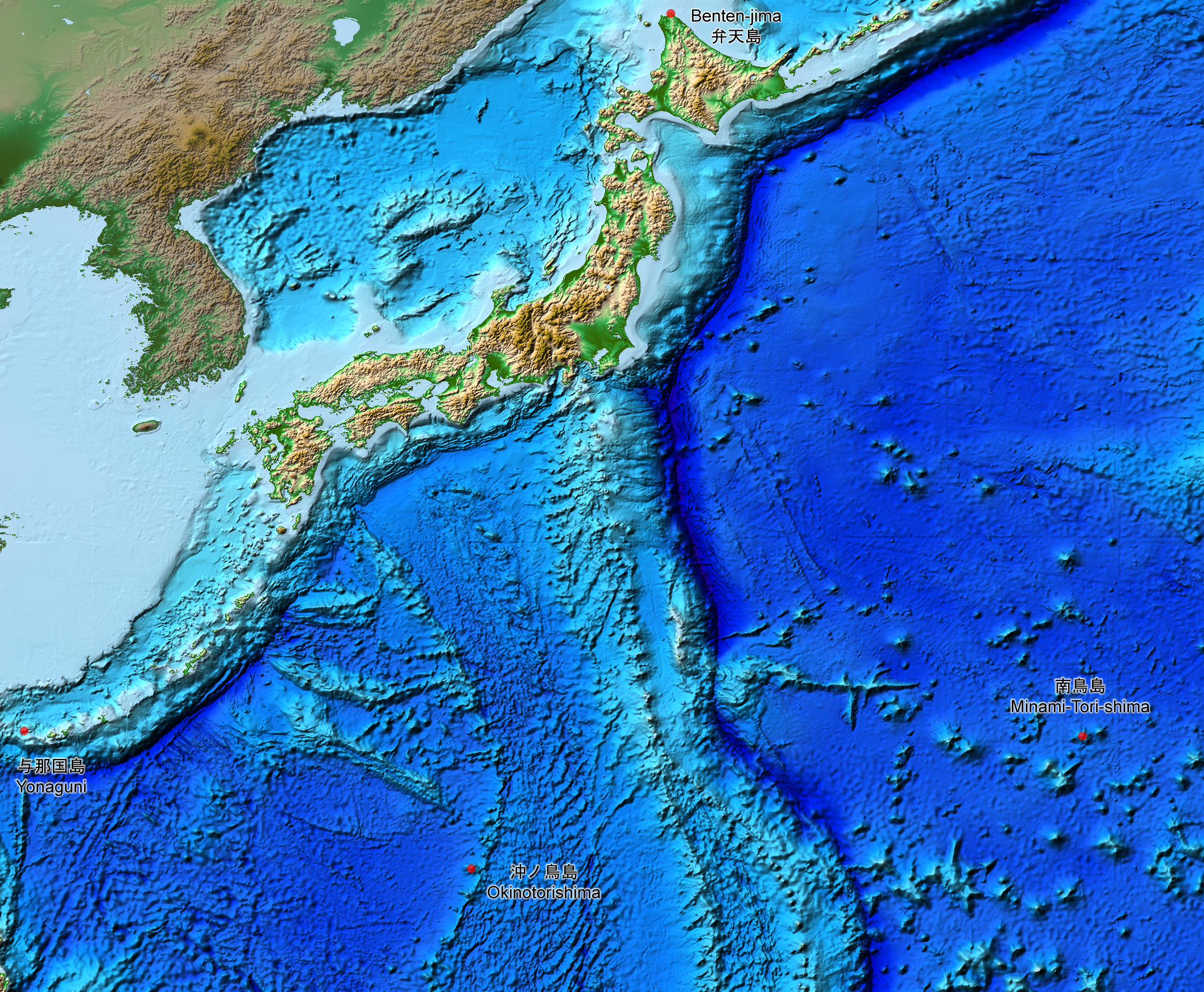
English: This is a relief map of the land and the seabed of Japan. It shows the surface and underwater terrain of the Japanese archipelago. It includes all the Japanese islands such as Minami-Tori-Shima, Benten-jima, Okinotorishima and Yonaguni.
日本語: 日本近海海底地形図と日本列島。 |
| تریخ | |
| سروت | ETOPO1, Global Relief Model, https://www.ngdc.noaa.gov/mgg/global/global.html |
| لکھاری | NASA, National Geophysical Data Center, NOAA |
لائسنس –
| This file is in the public domain in the United States because it was solely created by NASA. NASA copyright policy states that "NASA material is not protected by copyright unless noted". (See Template:PD-USGov, NASA copyright policy page or JPL Image Use Policy.) | ||
 |
Warnings:
|
فائل دی تریخ
فائل نو اس ویلے دی حالت وچ ویکھن واسطے تاریخ/ویلے تے کلک کرو۔
| تریخ تے ویلہ | نکی مورت | پاسے | ورتن والا | تیپّݨی کرو | |
|---|---|---|---|---|---|
| موجودہ | ۲۰:۰۷, ۵ اگست ۲۰۱۹ | | ۲,۱۱۷ × ۱,۷۴۵ (۷.۴۷ میگابائٹ) | Artanisen | The continent geography is darker to highlight the Japanese archipelago. |
| ۱۱:۲۹, ۲۲ جولائی ۲۰۱۹ |  | ۲,۱۱۷ × ۱,۷۴۵ (۷.۵۴ میگابائٹ) | Artanisen | User created page with UploadWizard |
فائل دی ورتوں
تھلے دتے گئے 1 صفحے اس فائل نال جُڑدے نیں
فائل ویاپک ورتوں
ایہہ دوجے وکیاں ایس فائل نوں ورتدے نیں –
- ar.wikipedia.org تے ورتوں
- ast.wikipedia.org تے ورتوں
- be.wikipedia.org تے ورتوں
- ca.wikipedia.org تے ورتوں
- de.wikipedia.org تے ورتوں
- en.wikipedia.org تے ورتوں
- es.wikipedia.org تے ورتوں
- fr.wikipedia.org تے ورتوں
- id.wikipedia.org تے ورتوں
- it.wikipedia.org تے ورتوں
- ja.wikipedia.org تے ورتوں
- min.wikipedia.org تے ورتوں
- pt.wikipedia.org تے ورتوں
- ru.wikipedia.org تے ورتوں
- sl.wikipedia.org تے ورتوں
- sr.wikipedia.org تے ورتوں
- tl.wikipedia.org تے ورتوں
- uk.wikipedia.org تے ورتوں
- vi.wikipedia.org تے ورتوں
- www.wikidata.org تے ورتوں
- zh-min-nan.wikipedia.org تے ورتوں
- zh.wikipedia.org تے ورتوں