
فائل:Kingdom of France 1000.svg

Size of this PNG preview of this SVG file: ۴۸۵ × ۳۴۰ پکسلز. دوجے ریزولوشنز: ۳۲۰ × ۲۲۴ پکسلز | ۶۴۰ × ۴۴۹ پکسلز | ۱,۰۲۴ × ۷۱۸ پکسلز | ۱,۲۸۰ × ۸۹۷ پکسلز | ۲,۵۶۰ × ۱,۷۹۵ پکسلز ۔
اصل فائل (ایس وی جی فائل، پکسل:۴۸۵ × ۳۴۰، فائل سائز: ۱.۲۲ میگابائٹ)
خلاصہ
This W3C-unspecified vector image was created with Inkscape .


.svg)
.svg)
.svg)
.svg)
.svg)


.svg)
.svg)
.svg)


.png)
.png)


.svg)


.svg)

.svg)


.svg)
.svg)
.svg)
.svg)


.svg)
.png)


.svg)


.svg)
.svg)


.svg)


.svg)


.svg)
.svg)
.svg)
.svg)
.svg)
.svg)
.svg)
.svg)
_cropped.svg)
.svg)
.svg)
.svg)
.svg)
.svg)
.svg)
.svg)
.svg)
.svg)
.svg)
.svg)
.svg)
.svg)
.svg)
.svg)
.svg)
.svg)
.svg)
.svg)
.svg)
.svg)
.svg)
.svg)
.svg)
.svg)
.svg)
.svg)
.svg)
.svg)
.svg)
.svg)
.svg)
.svg)
.svg)
.svg)
.svg)
.svg)
.svg)
.svg)
.svg)
.svg)
.svg)
.svg)
.svg)
.svg)
لائسنس –
This file is licensed under the Creative Commons Attribution-Share Alike 4.0 International license.
- تہانوں کھلھ اے:
- حصہ کرنا – کاپی، ونڈنا تے کم بھیجنا
- فیر رلانا – کم نوں فٹ کرنا
- تھلے دتیاں شرطاں نال:
- کس دے ناں – تسیں لازمی ایس کم دے بناں والے بارے دسو جنج اونے آکھیا اے یا جنج لسنس چ آکھیا گیا ہے۔
- اکو جہا شئیر کرو۔ – اگر تسیں بدلدے یا ایس کم تے بناندے تے بنن والے کم نوں اینج دے لسنس نال ای ونڈو گے۔
فائل دی تریخ
فائل نو اس ویلے دی حالت وچ ویکھن واسطے تاریخ/ویلے تے کلک کرو۔
| تریخ تے ویلہ | نکی مورت | پاسے | ورتن والا | تیپّݨی کرو | |
|---|---|---|---|---|---|
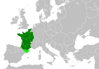
| موجودہ | ۰۳:۵۵, ۲۰ جولائی ۲۰۲۳ | | ۴۸۵ × ۳۴۰ (۱.۲۲ میگابائٹ) | DaniCBP | The counties of Barcelona and Aragon were autonomous (de facto independent) and not an integral part of the realm) |
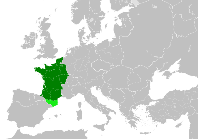
| ۲۱:۲۲, ۲۳ مئی ۲۰۱۶ |  | ۴۸۵ × ۳۴۰ (۱.۲۵ میگابائٹ) | Alphathon | Corrected Flanders and incorporated some islands into their respective counties/duchies | |
| ۱۹:۴۱, ۲۳ مئی ۲۰۱۶ |  | ۴۸۵ × ۳۴۰ (۱.۲۵ میگابائٹ) | Alphathon | Corrected status of Bohemia | |
| ۲۳:۱۳, ۲۲ مئی ۲۰۱۶ |  | ۴۸۵ × ۳۴۰ (۱.۲۳ میگابائٹ) | Alphathon | Split Capua from Benevento and removed both from HRE, along with Spoleto | |
| ۲۱:۴۶, ۲۲ مئی ۲۰۱۶ |  | ۴۸۵ × ۳۴۰ (۱.۲۴ میگابائٹ) | Alphathon | == {{int:filedesc}} == {{Inkscape}} {{Information |Description={{en|A map of the en:Kingdom of France within Europe circa 1000 CE. The main subdivisions of the Byzantine Empire, Holy Roman Empire, Burgundy, France and Poland are also shown.}} |So... |
فائل دی ورتوں
اس فائل نال جڑیا کوئی صفحہ نئیں۔
فائل ویاپک ورتوں
ایہہ دوجے وکیاں ایس فائل نوں ورتدے نیں –
- arz.wikipedia.org تے ورتوں
- cs.wikipedia.org تے ورتوں
- da.wikipedia.org تے ورتوں
- en.wikipedia.org تے ورتوں
- es.wikipedia.org تے ورتوں
- fa.wikipedia.org تے ورتوں
- he.wikipedia.org تے ورتوں
- ie.wikipedia.org تے ورتوں
- it.wikipedia.org تے ورتوں
- ko.wikipedia.org تے ورتوں
- mn.wikipedia.org تے ورتوں
- nrm.wikipedia.org تے ورتوں
- simple.wikipedia.org تے ورتوں
- sl.wikipedia.org تے ورتوں
- th.wikipedia.org تے ورتوں
- tr.wikipedia.org تے ورتوں
- uk.wikipedia.org تے ورتوں
- ur.wikipedia.org تے ورتوں
- vi.wikipedia.org تے ورتوں
- www.wikidata.org تے ورتوں
- zh.wikipedia.org تے ورتوں
.svg)