
فائل:Lake Tiberias (Sea of Galilee), Northern Israel.jpg
ایس وکھالے دا ناپ: ۳۹۸ × ۵۹۹ پکسلز۔ دوجے ریزولوشنز: ۱۵۹ × ۲۴۰ پکسلز | ۳۱۹ × ۴۸۰ پکسلز | ۵۱۰ × ۷۶۸ پکسلز | ۶۸۰ × ۱,۰۲۴ پکسلز | ۱,۴۴۰ × ۲,۱۶۸ پکسلز ۔
اصل فائل (۱,۴۴۰ × ۲,۱۶۸ پکسلز, فائل حجم: ۱.۱۵ میگابائٹ, MIME type: image/jpeg)
,_Northern_Israel.jpg)
خلاصہ
| تفصیل |
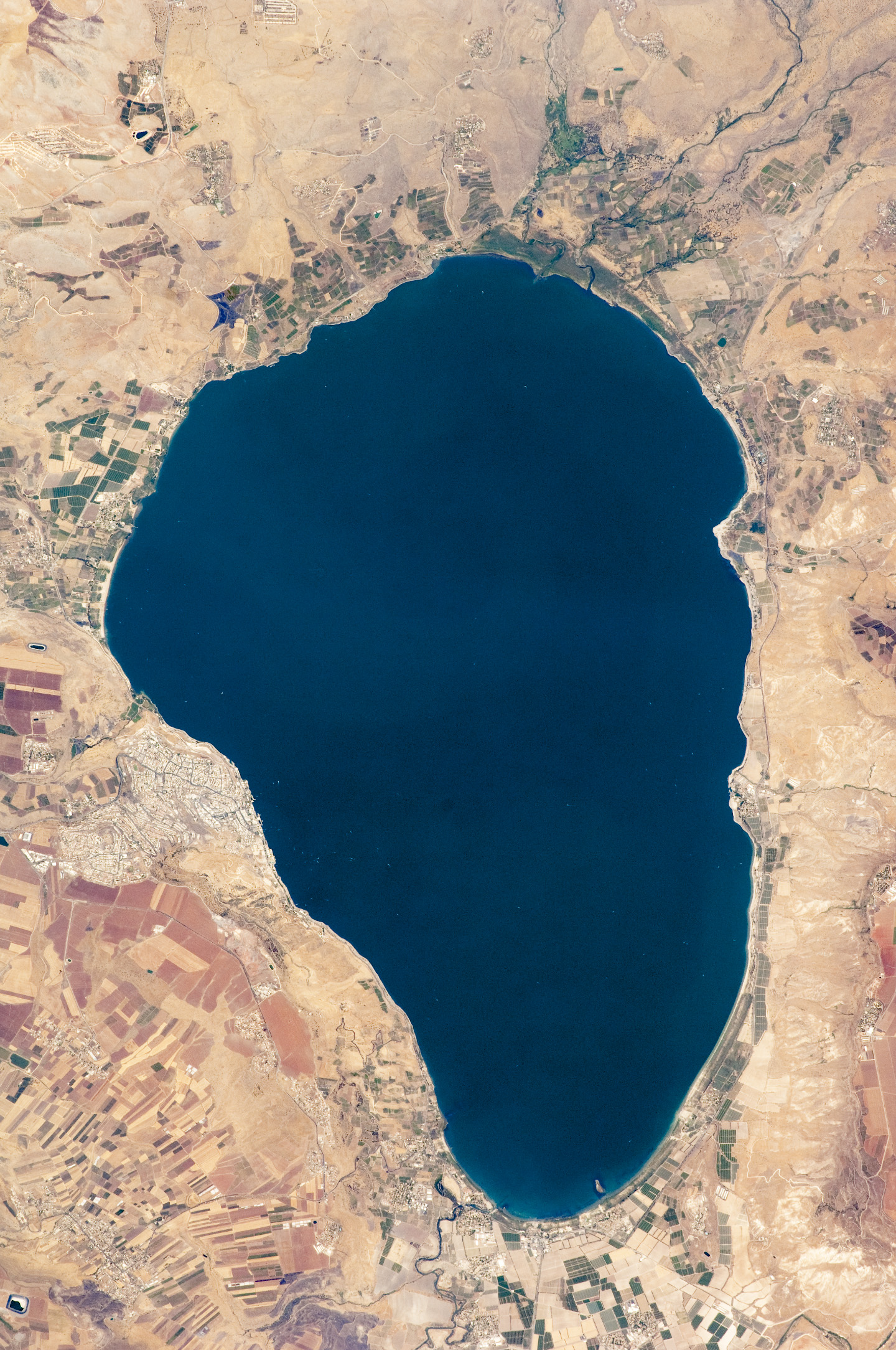
English: Israel’s largest freshwater lake, Lake Tiberias, is also known as the Sea of Tiberias, Lake of Gennesaret, Lake Kinneret, and the Sea of Galilee. The lake measures just more than 21 kilometres north-south, and it is only 43 meters deep. The lake is fed partly by underground springs related to the Jordan sector of the Great Rift Valley, but most of its water comes from the Jordan River, which enters from the north. The river’s winding course can be seen draining the south end of the lake at image bottom. Angular green and brown field patterns clothe most hillsides in this arid landscape. Bright roof tops are the hallmark of several villages in the area. The largest grouping of bright roofs and city blocks indicates the location of Tiberias (named for the Roman Emperor Tiberius), visible at image left on the south-western shore of the lake.
|
||||||||||||||||||||||||||||||||||||||||||||||||||
| تریخ | |||||||||||||||||||||||||||||||||||||||||||||||||||
| سروت | NASA Earth Observatory | ||||||||||||||||||||||||||||||||||||||||||||||||||
| لکھاری | This image was taken by the NASA Expedition 20 crew. | ||||||||||||||||||||||||||||||||||||||||||||||||||
| دوجے ورژن | Derivative works of this file: (Sea of Galilee Northern Israel-2.jpg | ||||||||||||||||||||||||||||||||||||||||||||||||||
Image acquired with a Nikon D2Xs digital camera fitted with an 400 mm lens, and is provided by the ISS Crew Earth Observations experiment and Image Science & Analysis Laboratory, Johnson Space Centre.
لائسنس –
| This file is in the public domain in the United States because it was solely created by NASA. NASA copyright policy states that "NASA material is not protected by copyright unless noted". (See Template:PD-USGov, NASA copyright policy page or JPL Image Use Policy.) | ||
 |
Warnings:
|
فائل دی تریخ
فائل نو اس ویلے دی حالت وچ ویکھن واسطے تاریخ/ویلے تے کلک کرو۔
| تریخ تے ویلہ | نکی مورت | پاسے | ورتن والا | تیپّݨی کرو | |
|---|---|---|---|---|---|
| موجودہ | ۱۶:۳۲, ۱۴ ستمبر ۲۰۰۹ | | ۱,۴۴۰ × ۲,۱۶۸ (۱.۱۵ میگابائٹ) | Originalwana | {{Information |Description={{en|1=Israel’s largest freshwater lake, Lake Tiberias, is also known as the Sea of Tiberias, Lake of Gennesaret, Lake Kinneret, and the Sea of Galilee. The lake measures just more than 21 kilometres north-south, and it is |
فائل دی ورتوں
تھلے دتے گئے 1 صفحے اس فائل نال جُڑدے نیں
فائل ویاپک ورتوں
ایہہ دوجے وکیاں ایس فائل نوں ورتدے نیں –
- af.wikipedia.org تے ورتوں
- ar.wikipedia.org تے ورتوں
- bn.wikipedia.org تے ورتوں
- br.wikipedia.org تے ورتوں
- ceb.wikipedia.org تے ورتوں
- cy.wikipedia.org تے ورتوں
- de.wikipedia.org تے ورتوں
- el.wikipedia.org تے ورتوں
- en.wikipedia.org تے ورتوں
- en.wikivoyage.org تے ورتوں
- eo.wikipedia.org تے ورتوں
- es.wikipedia.org تے ورتوں
- eu.wikipedia.org تے ورتوں
- fy.wikipedia.org تے ورتوں
- ga.wikipedia.org تے ورتوں
- he.wikipedia.org تے ورتوں
- ויקיפדיה:תמונה מומלצת/המלצות קודמות/יולי 2012
- ויקיפדיה:תמונה מומלצת/הוספה למומלצים/ארכיון 40
- תבנית:תמונה מומלצת 23 ביולי 2012
- ויקיפדיה:ערכים מומלצים/המלצות קודמות/יולי 2013
- פורטל:ערכים מומלצים/ערכים/הכנרת
- תבנית:ערך מומלץ 1 ביולי 2013
- תבנית:ערך מומלץ 2 ביולי 2013
- ויקיפדיה:ערכים מומלצים/המלצות קודמות/פברואר 2018
- תבנית:ערך מומלץ 11 בפברואר 2018
- תבנית:ערך מומלץ 12 בפברואר 2018
- he.wikivoyage.org تے ورتوں
- hy.wikipedia.org تے ورتوں
- ia.wikipedia.org تے ورتوں
- id.wikipedia.org تے ورتوں
ایس فائل دا ویکھو ہور جگت ورتن .
,_Northern_Israel.jpg)
,_Northern_Israel.jpg)