
فائل:Leizhou peninsula.jpg

ایس وکھالے دا ناپ: ۶۲۹ × ۶۰۰ پکسلز۔ دوجے ریزولوشنز: ۲۵۲ × ۲۴۰ پکسلز | ۵۰۳ × ۴۸۰ پکسلز | ۸۰۶ × ۷۶۸ پکسلز | ۱,۰۷۴ × ۱,۰۲۴ پکسلز | ۱,۳۹۷ × ۱,۳۳۲ پکسلز ۔
اصل فائل (۱,۳۹۷ × ۱,۳۳۲ پکسلز, فائل حجم: ۵۱۷ کلوبائٹ, MIME type: image/jpeg)
خلاصہ
| تفصیل |
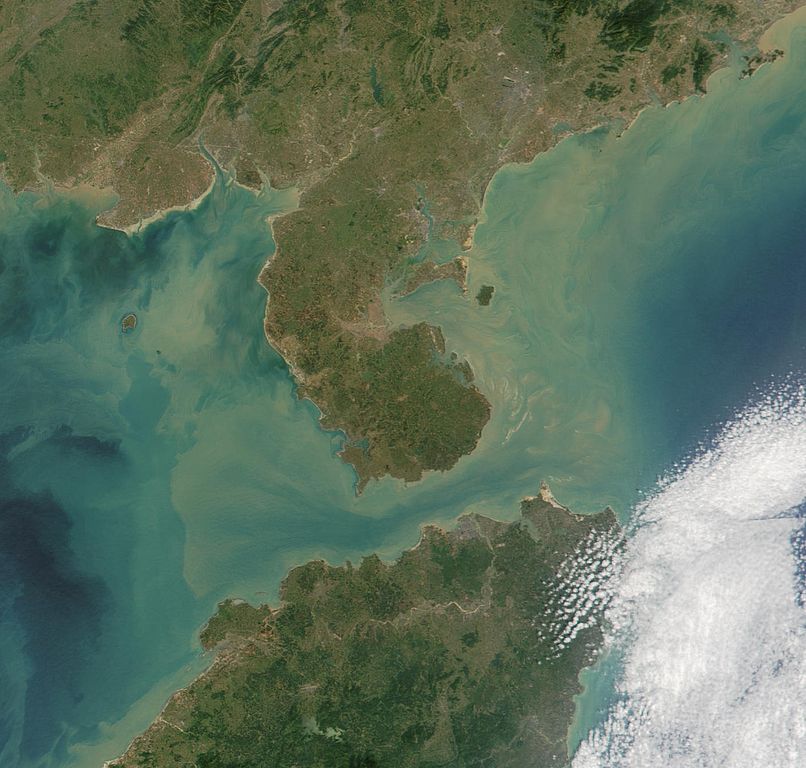
Satelite image of Leizhou Peninsula, and south across Qiongzhou Strait to Hainan island — in the Provinces of Guangdong (peninsula) and Hainan (island), in Southeast China. 中文(繁體):雷州半島衛星圖像
中文(简体):雷州半岛卫星图像 |
| تریخ | |
| سروت | NASA Visible Earth. cropped from http://visibleearth.nasa.gov/view_rec.php?id=2301 |
| لکھاری | NASA |
لائسنس –
| This file is in the public domain in the United States because it was solely created by NASA. NASA copyright policy states that "NASA material is not protected by copyright unless noted". (See Template:PD-USGov, NASA copyright policy page or JPL Image Use Policy.) | ||
 |
Warnings:
|
فائل دی تریخ
فائل نو اس ویلے دی حالت وچ ویکھن واسطے تاریخ/ویلے تے کلک کرو۔
| تریخ تے ویلہ | نکی مورت | پاسے | ورتن والا | تیپّݨی کرو | |
|---|---|---|---|---|---|
| موجودہ | ۱۶:۰۶, ۲۵ اگست ۲۰۰۷ | | ۱,۳۹۷ × ۱,۳۳۲ (۵۱۷ کلوبائٹ) | ChongDae | {{Information |Description=Satelite image of en:Leizhou Peninsula. |Source=NASA Visible Earth. cropped from http://visibleearth.nasa.gov/view_rec.php?id=2301 |Date=2001-11-16 |Author=NASA, ~~~ |Permission= |other_versions= }} [[Category:Satellite p |
فائل دی ورتوں
تھلے دتے گئے 2 صفحے اس فائل نال جُڑدے نیں
فائل ویاپک ورتوں
ایہہ دوجے وکیاں ایس فائل نوں ورتدے نیں –
- ar.wikipedia.org تے ورتوں
- arz.wikipedia.org تے ورتوں
- ast.wikipedia.org تے ورتوں
- az.wikipedia.org تے ورتوں
- bg.wikipedia.org تے ورتوں
- bn.wikipedia.org تے ورتوں
- ca.wikipedia.org تے ورتوں
- ce.wikipedia.org تے ورتوں
- cs.wikipedia.org تے ورتوں
- cy.wikipedia.org تے ورتوں
- da.wikipedia.org تے ورتوں
- de.wikipedia.org تے ورتوں
- de.wikivoyage.org تے ورتوں
- el.wikipedia.org تے ورتوں
- en.wikipedia.org تے ورتوں
- es.wikipedia.org تے ورتوں
- eu.wikipedia.org تے ورتوں
- fi.wikipedia.org تے ورتوں
- fr.wikipedia.org تے ورتوں
- fr.wikivoyage.org تے ورتوں
- fy.wikipedia.org تے ورتوں
- ga.wikipedia.org تے ورتوں
- gl.wikipedia.org تے ورتوں
- he.wikipedia.org تے ورتوں
- hy.wikipedia.org تے ورتوں
- ia.wikipedia.org تے ورتوں
- id.wikipedia.org تے ورتوں
- it.wikipedia.org تے ورتوں
- ja.wikipedia.org تے ورتوں
- ka.wikipedia.org تے ورتوں
- ko.wikipedia.org تے ورتوں
- ku.wikipedia.org تے ورتوں
- lmo.wikipedia.org تے ورتوں
- lt.wikipedia.org تے ورتوں
- mk.wikipedia.org تے ورتوں
- mzn.wikipedia.org تے ورتوں
- nl.wikipedia.org تے ورتوں
ایس فائل دا ویکھو ہور جگت ورتن .