
فائل:London Underground Overground DLR Crossrail map.svg

Size of this PNG preview of this SVG file: ۸۰۰ × ۴۲۲ پکسلز. دوجے ریزولوشنز: ۳۲۰ × ۱۶۹ پکسلز | ۶۴۰ × ۳۳۸ پکسلز | ۱,۰۲۴ × ۵۴۱ پکسلز | ۱,۲۸۰ × ۶۷۶ پکسلز | ۲,۵۶۰ × ۱,۳۵۲ پکسلز | ۲,۵۰۰ × ۱,۳۲۰ پکسلز ۔
اصل فائل (Animated SVG file, nominally ۲,۵۰۰ × ۱,۳۲۰ pixels, file size: ۲۱۹ کلوبائٹ)
Note: Due to technical limitations, thumbnails of this file will not be animated.
خلاصہ
| تفصیل |
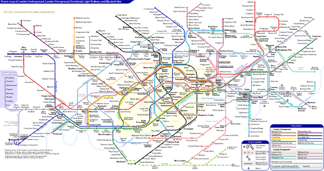
English: *Route map of London Underground, London Overground, Docklands Light Railway and Elizabeth line (Crossrail), including most green-lighted proposals.
|
|||
| تریخ | ||||
| سروت | آپݨا کم | |||
| لکھاری | Sameboat | |||
| اجازت (فائل نوں دوبارہ ورتنا) |
میں، اس کم دے کاپیرائٹ دا مالک، اس کم نوں اس لائسنس دے مطابق چھاپدا واں: This file is licensed under the Creative Commons Attribution-Share Alike 4.0 International license.
|
|||
| دوجے ورژن |
|
|||
| SVG genesis | This icon was created with unknown tool. This icon uses embedded text that can be easily translated using a text editor. |


|
This image is an animated SVG file. The .png preview above created by RSVG for use in Wikimedia is not animated and may be incomplete or incorrect. To see the animation, open media:London Underground Overground DLR Crossrail map.svg. It should run in any modern browser or viewer. Recent versions of Chrome, Firefox, Microsoft Edge, Safari, and Opera all support SVG animated with SMIL.
Other SVG animations can be found at Category:Animated SVG files.
|

فائل دی تریخ
فائل نو اس ویلے دی حالت وچ ویکھن واسطے تاریخ/ویلے تے کلک کرو۔
| تریخ تے ویلہ | نکی مورت | پاسے | ورتن والا | تیپّݨی کرو | |
|---|---|---|---|---|---|
| موجودہ | ۱۱:۲۷, ۲۵ مارچ ۲۰۲۴ | | ۲,۵۰۰ × ۱,۳۲۰ (۲۱۹ کلوبائٹ) | Sameboat | change OOC icon to NR |
| ۱۱:۲۲, ۲۳ مارچ ۲۰۲۴ |  | ۲,۵۰۰ × ۱,۳۲۰ (۲۱۹ کلوبائٹ) | Sameboat | restore changes made by The wub and Jc86035 | |
| ۱۱:۱۷, ۲۳ مارچ ۲۰۲۴ |  | ۲,۵۰۰ × ۱,۳۲۰ (۲۱۹ کلوبائٹ) | Sameboat | + Old Oak Common | |
| ۰۴:۱۶, ۲۰ مارچ ۲۰۲۴ |  | ۲,۵۰۰ × ۱,۳۲۰ (۲۱۹ کلوبائٹ) | The wub | Update cable car, add tooltip for Woolwich/Woolwich Arsenal interchange | |
| ۰۲:۵۴, ۲۰ فروری ۲۰۲۴ |  | ۲,۵۰۰ × ۱,۳۲۰ (۲۱۹ کلوبائٹ) | Jc86035 | Wandsworth Road | |
| ۰۶:۰۹, ۱۹ فروری ۲۰۲۴ |  | ۲,۵۰۰ × ۱,۳۲۰ (۲۱۹ کلوبائٹ) | Sameboat | ||
| ۱۹:۴۲, ۱۶ فروری ۲۰۲۴ |  | ۲,۵۰۰ × ۱,۳۲۰ (۲۱۹ کلوبائٹ) | Sameboat | ||
| ۱۹:۳۷, ۱۶ فروری ۲۰۲۴ |  | ۲,۵۰۰ × ۱,۳۲۰ (۲۱۹ کلوبائٹ) | Sameboat | overground new names and new colors | |
| ۱۱:۰۳, ۷ نومبر ۲۰۲۲ |  | ۲,۵۰۰ × ۱,۳۲۰ (۲۲۱ کلوبائٹ) | Sameboat | Pudding Mill Lane portal | |
| ۱۰:۱۹, ۶ نومبر ۲۰۲۲ |  | ۲,۵۰۰ × ۱,۳۲۰ (۲۲۴ کلوبائٹ) | Sameboat | Elizabeth line thru Paddington |
فائل دی ورتوں
تھلے دتے گئے 1 صفحے اس فائل نال جُڑدے نیں
فائل ویاپک ورتوں
ایہہ دوجے وکیاں ایس فائل نوں ورتدے نیں –
- af.wikipedia.org تے ورتوں
- ar.wikipedia.org تے ورتوں
- ca.wikipedia.org تے ورتوں
- de.wikipedia.org تے ورتوں
- en.wikipedia.org تے ورتوں
- Tube map
- Transport for London
- Schematic
- List of London Underground stations
- London Rail
- Wikipedia:Wikipedia Signpost/2015-06-03/In the media
- Wikipedia:Wikipedia Signpost/Single/2015-06-03
- User:Bellowhead678/sandbox
- Elizabeth line
- User:RogerNiceEyes/sandbox
- Talk:Elizabeth line
- Glossary of geography terms (N–Z)
- en.wikivoyage.org تے ورتوں
- es.wikipedia.org تے ورتوں
- es.wikivoyage.org تے ورتوں
- fa.wikipedia.org تے ورتوں
- fi.wikipedia.org تے ورتوں
- fr.wikipedia.org تے ورتوں
- Liste des stations du métro de Londres
- Woodside Park (métro de Londres)
- Gare de Moorgate
- High Barnet (métro de Londres)
- Totteridge & Whetstone (métro de Londres)
- Morden (métro de Londres)
- Burnt Oak (métro de Londres)
- West Finchley (métro de Londres)
- Brent Cross (métro de Londres)
- Golders Green (métro de Londres)
- Kensal Green (métro de Londres)
- Queen's Park (métro de Londres)
- Finchley Central (métro de Londres)
- Colliers Wood (métro de Londres)
- Mill Hill East (métro de Londres)
- Edgware (métro de Londres)
- Balham (métro de Londres)
- Barking (métro de Londres)
- Colindale (métro de Londres)
- Hendon Central (métro de Londres)
- Kilburn Park (métro de Londres)
ایس فائل دا ویکھو ہور جگت ورتن .