
فائل:MarsTopoMap-PIA02031 modest.jpg

ایس وکھالے دا ناپ: ۶۷۴ × ۶۰۰ پکسلز۔ دوجے ریزولوشنز: ۲۷۰ × ۲۴۰ پکسلز | ۵۴۰ × ۴۸۰ پکسلز | ۸۶۴ × ۷۶۸ پکسلز | ۱,۱۵۱ × ۱,۰۲۴ پکسلز | ۲,۴۹۷ × ۲,۲۲۱ پکسلز ۔
اصل فائل (۲,۴۹۷ × ۲,۲۲۱ پکسلز, فائل حجم: ۱.۰۹ میگابائٹ, MIME type: image/jpeg)
خلاصہ


| تفصیل |
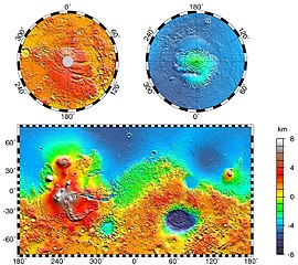
English: Maps of Mars' global topography. The projections are Mercator to 70° latitude and stereographic at the poles with the south pole at left and north pole at right. Note the elevation difference between the northern and southern hemispheres. The Tharsis volcano-tectonic province is centered near the equator in the longitude range 220° E to 300° E and contains the vast east-west trending Valles Marineris canyon system and several major volcanic shields including Olympus Mons (18° N, 225° E), Alba Patera (42° N, 252° E), Ascraeus Mons (12° N, 248° E), Pavonis Mons (0°, 247° E), and Arsia Mons (9° S, 239° E). Regions and structures discussed in the text include Solis Planum (25° S, 270° E), Lunae Planum (10° N, 290° E), and Claritas Fossae (30° S, 255° E). Major impact basins include Hellas (45° S, 70° E), Argyre (50° S, 320° E), Isidis (12° N, 88° E), and Utopia (45° N, 110° E). This analysis uses an areocentric coordinate convention with east longitude positive.
Русский: Топографическая карта Марса. |
| تریخ | |
| سروت |
http://photojournal.jpl.nasa.gov/jpeg/PIA02031.jpg
|
| لکھاری | NASA/JPL-Caltech/GSFC |
| اجازت (فائل نوں دوبارہ ورتنا) |
PD-USGOV-NASA |
This image or video was catalogued by Jet Propulsion Laboratory of the United States National Aeronautics and Space Administration (NASA) under Photo ID: PIA02031. This tag does not indicate the copyright status of the attached work. A normal copyright tag is still required. See Commons:Licensing. Other languages:
|
لائسنس –
| This file is in the public domain in the United States because it was solely created by NASA. NASA copyright policy states that "NASA material is not protected by copyright unless noted". (See Template:PD-USGov, NASA copyright policy page or JPL Image Use Policy.) | ||
 |
Warnings:
|
پہلا اپلوڈ دا ریکارڈ
The original description page was here. All following user names refer to en.wikipedia.
- 2004-05-06 16:52 Wwoods 612×545×8 (88223 bytes) Topographic Map of Mars; http://photojournal.jpl.nasa.gov/catalog/PIA02031 ; {{msg:PD}}
| Annotations | This image is annotated: View the annotations at Commons |


فائل دی تریخ
فائل نو اس ویلے دی حالت وچ ویکھن واسطے تاریخ/ویلے تے کلک کرو۔
| تریخ تے ویلہ | نکی مورت | پاسے | ورتن والا | تیپّݨی کرو | |
|---|---|---|---|---|---|
| موجودہ | ۰۵:۴۳, ۲۲ مارچ ۲۰۰۵ | | ۲,۴۹۷ × ۲,۲۲۱ (۱.۰۹ میگابائٹ) | Wikibob~commonswiki | high res jpg from http://photojournal.jpl.nasa.gov/jpeg/PIA02031.jpg PD |
| ۲۱:۴۰, ۳۰ دسمبر ۲۰۰۴ |  | ۶۱۲ × ۵۴۵ (۸۶ کلوبائٹ) | Kristaga | NASA-photo, all NASA images are free to use. |
فائل دی ورتوں
تھلے دتے گئے 1 صفحے اس فائل نال جُڑدے نیں
فائل ویاپک ورتوں
ایہہ دوجے وکیاں ایس فائل نوں ورتدے نیں –
- als.wikipedia.org تے ورتوں
- ar.wikipedia.org تے ورتوں
- be.wikipedia.org تے ورتوں
- bg.wikipedia.org تے ورتوں
- bo.wikipedia.org تے ورتوں
- ca.wikipedia.org تے ورتوں
- ca.wikibooks.org تے ورتوں
- cv.wikipedia.org تے ورتوں
- de.wikipedia.org تے ورتوں
- el.wikipedia.org تے ورتوں
- en.wikipedia.org تے ورتوں
- User:Mcdavis941/mars
- Wikipedia:Reference desk/Science/Archive
- User:Scholar743/subpage3
- Mars ocean theory
- Phaethontis quadrangle
- Water on Mars
- Ptolemaeus (Martian crater)
- Tader Valles
- Gorgonum Chaos
- Wikipedia:Reference desk/Archives/Science/2010 September 26
- User talk:Wikileadspresident
- List of largest craters in the Solar System
- User:Jimmarsmars/sandbox
- Lakes on Mars
- en.wikiversity.org تے ورتوں
- es.wikipedia.org تے ورتوں
- eu.wikipedia.org تے ورتوں
- fa.wikipedia.org تے ورتوں
- fi.wikipedia.org تے ورتوں
- fr.wikipedia.org تے ورتوں
- gl.wikipedia.org تے ورتوں
- he.wikipedia.org تے ورتوں
- hi.wikipedia.org تے ورتوں
- hr.wikipedia.org تے ورتوں
- hu.wikipedia.org تے ورتوں
ایس فائل دا ویکھو ہور جگت ورتن .