
فائل:Misak-i milli.png

ایس وکھالے دا ناپ: ۸۰۰ × ۴۹۳ پکسلز۔ دوجے ریزولوشنز: ۳۲۰ × ۱۹۷ پکسلز | ۶۴۰ × ۳۹۵ پکسلز | ۱,۰۲۴ × ۶۳۱ پکسلز | ۱,۴۷۴ × ۹۰۹ پکسلز ۔
اصل فائل (۱,۴۷۴ × ۹۰۹ پکسلز, فائل حجم: ۲۰۴ کلوبائٹ, MIME type: image/png)
خلاصہ
| تفصیل |
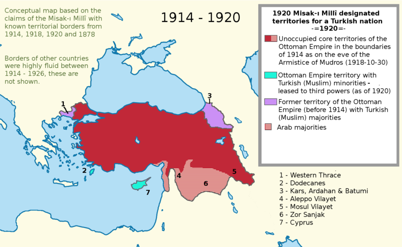
English: I worked more on the proposal map and I also added the current territories. This map shows the goal of the Turkish side. I used a Wikipedia map while I was working on this project. It is called "LocationTurkey2". --Please help me erasing the older one (Misak-ı_milli.PNG)--
Turkish variation: File:Misak-i_milli_tr.png |
| تریخ | ۲۳ فروری ۲۰۰۷ (original upload date) |
| سروت | Transferred from en.wikipedia to Commons. |
| لکھاری | Deliogul at English وکیپیڈیا |
لائسنس –
Deliogul from en.wikipedia.org، اس کم دے کاپیرائٹ دا مالک، اس کم نوں اس لائسنس دے مطابق چھاپدا واں:

|
کاپی کرن، ونڈن تے بدلن دی ایس ڈوکومنٹ لئی اجازت دتی جاندی اے ایہناں GNU Free Documentation License, Version 1.2 شرطاں نال یا مگروں کسے وی چھپے ورین Free Software Foundation توں بنا کسے انویرینٹ سیکشن دے، ناں فرنٹ کور لکھت تے ناں بیک کور لکھت دے۔ لسنس دی اک کاپی سیکشن وچ ہیگی اے جہدا ناں اے GNU Free Documentation License۔ |
| ایس فائل نوں کریٹو کامنز Attribution 2.5 پولینڈ لائسنس دتا گیا. | ||
| کس دے ناں: Deliogul | ||
| ||
| اس لائسنس دا ٹیگ GFDL دے مطابق اس فائل چ پایا گیا اے licensing update۔ |
پہلا اپلوڈ دا ریکارڈ
The original description page was here. All following user names refer to en.wikipedia.
- 2007-02-23 16:09 Deliogul 610×166×8 (27404 bytes) I worked more on the proposal map and I also added the current territories. This map shows the goal of the Turkish side. I used a Wikipedia map while I was working on this project. It is called "LocationTurkey2". --Please help me erasing the older one (Mi
فائل دی تریخ
فائل نو اس ویلے دی حالت وچ ویکھن واسطے تاریخ/ویلے تے کلک کرو۔
| تریخ تے ویلہ | نکی مورت | پاسے | ورتن والا | تیپّݨی کرو | |
|---|---|---|---|---|---|
| موجودہ | ۰۲:۴۳, ۱ دسمبر ۲۰۱۶ | | ۱,۴۷۴ × ۹۰۹ (۲۰۴ کلوبائٹ) | ScienceDawns | Removed redundant information, weasel word, cropped to part a until reliable encyclopedic sources can be provided linking the current situation to the Misak-ı Millî decisions. |
| ۰۱:۴۸, ۱۲ نومبر ۲۰۱۶ |  | ۱,۴۷۴ × ۱,۸۲۶ (۵۰۸ کلوبائٹ) | Metrancya | Complete replacement of the original file - the accuracy of the old file was disputed and the content of the old file did not match the text of the Misak-ı millî. The new file follows the Misak-ı millî word-by-word and outlines the original designa... | |
| ۰۳:۴۷, ۱۰ اپریل ۲۰۰۸ | ۶۱۰ × ۱۶۶ (۲۷ کلوبائٹ) | KureCewlik81 | {{Information |Description={{en|I worked more on the proposal map and I also added the current territories. This map shows the goal of the Turkish side. I used a Wikipedia map while I was working on this project. It is called "LocationTurkey2". --Please h |
فائل دی ورتوں
تھلے دتے گئے 1 صفحے اس فائل نال جُڑدے نیں
فائل ویاپک ورتوں
ایہہ دوجے وکیاں ایس فائل نوں ورتدے نیں –
- ar.wikipedia.org تے ورتوں
- arz.wikipedia.org تے ورتوں
- azb.wikipedia.org تے ورتوں
- az.wikipedia.org تے ورتوں
- ca.wikipedia.org تے ورتوں
- de.wikipedia.org تے ورتوں
- el.wikipedia.org تے ورتوں
- en.wikipedia.org تے ورتوں
- he.wikipedia.org تے ورتوں
- hu.wikipedia.org تے ورتوں
- hy.wikipedia.org تے ورتوں
- it.wikipedia.org تے ورتوں
- mk.wikipedia.org تے ورتوں
- nl.wikipedia.org تے ورتوں
- pt.wikipedia.org تے ورتوں
- ru.wikipedia.org تے ورتوں
- tr.wikipedia.org تے ورتوں
- uk.wikipedia.org تے ورتوں
- ur.wikipedia.org تے ورتوں
- www.wikidata.org تے ورتوں