
فائل:NZOffshoreIslandsMap.png
ایس وکھالے دا ناپ: ۸۰۰ × ۵۱۰ پکسلز۔ دوجے ریزولوشنز: ۳۲۰ × ۲۰۴ پکسلز | ۶۴۰ × ۴۰۸ پکسلز | ۹۱۱ × ۵۸۱ پکسلز ۔
اصل فائل (۹۱۱ × ۵۸۱ پکسلز, فائل حجم: ۷۶ کلوبائٹ, MIME type: image/png)

|
This map image could be re-created using vector graphics as an SVG file. This has several advantages; see Commons:Media for cleanup for more information. If an SVG form of this image is available, please upload it and afterwards replace this template with
{{vector version available|new image name}}.
It is recommended to name the SVG file “NZOffshoreIslandsMap.svg”—then the template Vector version available (or Vva) does not need the new image name parameter. |
خلاصہ
| تفصیل |
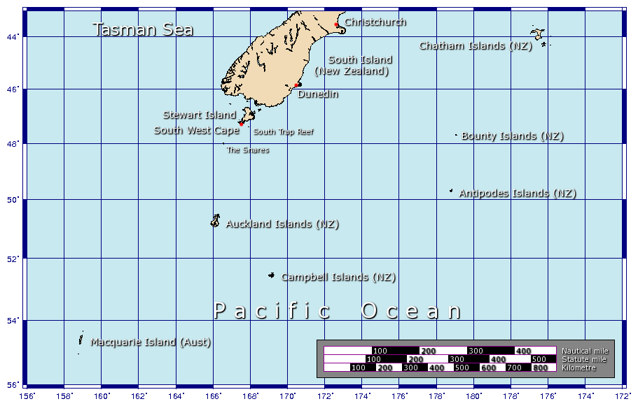
A map showing some of the outlying islands of New Zealand, including the Chatham Islands, Bounty Islands, Snares Islands, Antipodes Islands, Auckland Islands, and Campbell Islands, as well as Australia's Macquarie Island. Generated using GMT. |
| تریخ | ۲۹ جنوری ۲۰۰۶ (original upload date) |
| سروت | آپݨا کم |
| لکھاری | Johantheghost |
لائسنس –
میں، اس کم دے کاپیرائٹ دا مالک، اس کم نوں اس لائسنس دے مطابق چھاپدا واں:

|
کاپی کرن، ونڈن تے بدلن دی ایس ڈوکومنٹ لئی اجازت دتی جاندی اے ایہناں GNU Free Documentation License, Version 1.2 شرطاں نال یا مگروں کسے وی چھپے ورین Free Software Foundation توں بنا کسے انویرینٹ سیکشن دے، ناں فرنٹ کور لکھت تے ناں بیک کور لکھت دے۔ لسنس دی اک کاپی سیکشن وچ ہیگی اے جہدا ناں اے GNU Free Documentation License۔ |
| ایس فائل نوں کریٹو کامنز Attribution 2.5 پولینڈ لائسنس دتا گیا. | ||
| ||
| اس لائسنس دا ٹیگ GFDL دے مطابق اس فائل چ پایا گیا اے licensing update۔ |
ایس فائل نوں Creative Commons Attribution-Share Alike 2.5 Generic, 2.0 Generic and 1.0 Generic لسنس دتا گیا اے۔
- تہانوں کھلھ اے:
- حصہ کرنا – کاپی، ونڈنا تے کم بھیجنا
- فیر رلانا – کم نوں فٹ کرنا
- تھلے دتیاں شرطاں نال:
- کس دے ناں – تسیں لازمی ایس کم دے بناں والے بارے دسو جنج اونے آکھیا اے یا جنج لسنس چ آکھیا گیا ہے۔
- اکو جہا شئیر کرو۔ – اگر تسیں بدلدے یا ایس کم تے بناندے تے بنن والے کم نوں اینج دے لسنس نال ای ونڈو گے۔
تسیں اپنی مرضی دا لائسنس چݨ سکدے اوہ۔
فائل دی تریخ
فائل نو اس ویلے دی حالت وچ ویکھن واسطے تاریخ/ویلے تے کلک کرو۔
| تریخ تے ویلہ | نکی مورت | پاسے | ورتن والا | تیپّݨی کرو | |
|---|---|---|---|---|---|
| موجودہ | ۱۷:۲۵, ۹ فروری ۲۰۰۶ | | ۹۱۱ × ۵۸۱ (۷۶ کلوبائٹ) | Johantheghost | Less violent colours. |
| ۰۰:۳۷, ۳۰ جنوری ۲۰۰۶ |  | ۹۱۱ × ۵۸۱ (۷۵ کلوبائٹ) | Johantheghost | A map showing some of the outlying islands of New Zealand, including the Chatham Islands, Bounty Islands, [[Wikipedia:Antipodes Islands|Antipode |
فائل دی ورتوں
تھلے دتے گئے 1 صفحے اس فائل نال جُڑدے نیں
فائل ویاپک ورتوں
ایہہ دوجے وکیاں ایس فائل نوں ورتدے نیں –
- ast.wikipedia.org تے ورتوں
- az.wikipedia.org تے ورتوں
- be.wikipedia.org تے ورتوں
- bg.wikipedia.org تے ورتوں
- bn.wikipedia.org تے ورتوں
- br.wikipedia.org تے ورتوں
- ca.wikipedia.org تے ورتوں
- cs.wikipedia.org تے ورتوں
- de.wikipedia.org تے ورتوں
- el.wikipedia.org تے ورتوں
- en.wikipedia.org تے ورتوں
- en.wikinews.org تے ورتوں
- eo.wikipedia.org تے ورتوں
- es.wikipedia.org تے ورتوں
- et.wikipedia.org تے ورتوں
- fa.wikipedia.org تے ورتوں
- fi.wikipedia.org تے ورتوں
- fr.wikipedia.org تے ورتوں
- fr.wikivoyage.org تے ورتوں
- gl.wikipedia.org تے ورتوں
ایس فائل دا ویکھو ہور جگت ورتن .