
فائل:Northern Mali conflict.svg

Size of this PNG preview of this SVG file: ۶۲۹ × ۶۰۰ پکسلز. دوجے ریزولوشنز: ۲۵۲ × ۲۴۰ پکسلز | ۵۰۳ × ۴۸۰ پکسلز | ۸۰۵ × ۷۶۸ پکسلز | ۱,۰۷۴ × ۱,۰۲۴ پکسلز | ۲,۱۴۸ × ۲,۰۴۸ پکسلز | ۱,۳۱۶ × ۱,۲۵۵ پکسلز ۔
اصل فائل (ایس وی جی فائل، پکسل:۱,۳۱۶ × ۱,۲۵۵، فائل سائز: ۷۹۶ کلوبائٹ)
خلاصہ
| تفصیل |
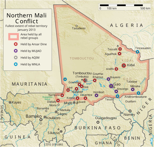
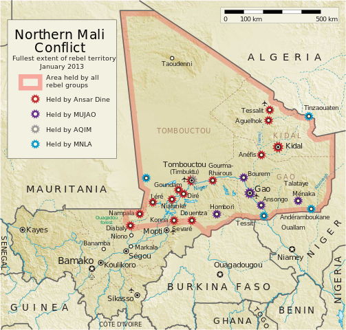
English: Map of the conflict in Northern Mali. (English)
العربية: خريطة الصّراع في شمال مالي. (إنجليزي)
Français : Carte du conflit au nord du Mali. (Anglais)
Latina: Charta rebellionis Tuaregorum in Malia septentrionali. (Anglice)
Українська: Карта конфлікту на півночі Малі. (Англійською) |
| سروت |
آپݨا کم This vector image includes elements that have been taken or adapted from this file: This vector image includes elements that have been taken or adapted from this file: |
| لکھاری | Orionist |
| دوجے ورژن | German/Deutsch/Allemand, French/Français, Macedonian/македонски јазик/Macédonien |
| SVG genesis |
Notes
- ↑ US Department of State, "Country Reports on Terrorism 2011", Chapter 2 Country Reports: Africa Overview, 31 July 2012
لائسنس –
میں، اس کم دے کاپیرائٹ دا مالک، اس کم نوں اس لائسنس دے مطابق چھاپدا واں:
ایس فائل نوں کریٹو کامنز Attribution 2.5 پولینڈ لائسنس دتا گیا.
- تہانوں کھلھ اے:
- حصہ کرنا – کاپی، ونڈنا تے کم بھیجنا
- فیر رلانا – کم نوں فٹ کرنا
- تھلے دتیاں شرطاں نال:
- کس دے ناں – تسیں لازمی ایس کم دے بناں والے بارے دسو جنج اونے آکھیا اے یا جنج لسنس چ آکھیا گیا ہے۔
- اکو جہا شئیر کرو۔ – اگر تسیں بدلدے یا ایس کم تے بناندے تے بنن والے کم نوں اینج دے لسنس نال ای ونڈو گے۔
فائل دی تریخ
فائل نو اس ویلے دی حالت وچ ویکھن واسطے تاریخ/ویلے تے کلک کرو۔
| تریخ تے ویلہ | نکی مورت | پاسے | ورتن والا | تیپّݨی کرو | |
|---|---|---|---|---|---|
| موجودہ | ۱۱:۵۹, ۸ اپریل ۲۰۱۴ | | ۱,۳۱۶ × ۱,۲۵۵ (۷۹۶ کلوبائٹ) | Ansh666 | Reverted to version as of 16:51, 8 March 2013 - restoring the correct version, as the map is supposed to be historical, not current |
| ۰۱:۱۵, ۶ دسمبر ۲۰۱۳ |  | ۱,۳۱۶ × ۱,۲۵۵ (۶۹۹ کلوبائٹ) | Hanibal911 | more accurately reflects the situation | |
| ۲۱:۵۱, ۸ مارچ ۲۰۱۳ |  | ۱,۳۱۶ × ۱,۲۵۵ (۷۹۶ کلوبائٹ) | Agricolae | Hombori dot restored | |
| ۱۹:۲۹, ۵ مارچ ۲۰۱۳ |  | ۱,۳۱۶ × ۱,۲۵۵ (۷۹۴ کلوبائٹ) | TUFKAAP | Since this is an English map, Al-Qaeda in the Islamic Maghreb should be abbreviated as AQIM. | |
| ۰۸:۳۳, ۱۱ فروری ۲۰۱۳ |  | ۱,۳۱۶ × ۱,۲۵۵ (۷۹۴ کلوبائٹ) | Agricolae | shift text distorted on upload | |
| ۰۸:۲۷, ۱۱ فروری ۲۰۱۳ |  | ۱,۳۱۶ × ۱,۲۵۵ (۷۹۴ کلوبائٹ) | Agricolae | change to show greatest extent - see WP Talk:Northern Mali conflict (2012–present) | |
| ۱۱:۳۶, ۸ فروری ۲۰۱۳ |  | ۱,۳۱۶ × ۱,۲۵۵ (۶۹۹ کلوبائٹ) | Rama | Aguelhok contested or taken ( http://www.lemonde.fr/afrique/article/2013/02/08/mali-les-forces-francaise-et-tchadiennes-a-aguelhok_1828906_3212.html ) | |
| ۱۵:۲۹, ۲ فروری ۲۰۱۳ |  | ۱,۳۱۶ × ۱,۲۵۵ (۶۹۸ کلوبائٹ) | U5K0 | Bourem to green as per talk page | |
| ۱۳:۴۱, ۳۰ جنوری ۲۰۱۳ |  | ۱,۳۱۶ × ۱,۲۵۵ (۶۷۹ کلوبائٹ) | Orionist | Updated map: Menaka, Anderamboukane, Ansongo, Dire, Kidal and other MNLA positions. Removed rebel area boundaries as the situation has become complicated. | |
| ۲۲:۲۳, ۲۹ جنوری ۲۰۱۳ |  | ۱,۳۱۶ × ۱,۲۵۵ (۸۹۴ کلوبائٹ) | Jaybear | Insertion of a map-scale in the upper right corner (added directly before the token "/svg" at end of svg-code); |
فائل دی ورتوں
تھلے دتے گئے 1 صفحے اس فائل نال جُڑدے نیں
فائل ویاپک ورتوں
ایہہ دوجے وکیاں ایس فائل نوں ورتدے نیں –
- af.wikipedia.org تے ورتوں
- ar.wikipedia.org تے ورتوں
- azb.wikipedia.org تے ورتوں
- az.wikipedia.org تے ورتوں
- bg.wikipedia.org تے ورتوں
- bn.wikipedia.org تے ورتوں
- ca.wikipedia.org تے ورتوں
- cs.wikipedia.org تے ورتوں
- cy.wikipedia.org تے ورتوں
- da.wikipedia.org تے ورتوں
- de.wikipedia.org تے ورتوں
- el.wikipedia.org تے ورتوں
- en.wikipedia.org تے ورتوں
- Mali
- Portal:Mali
- Insurgency in the Maghreb (2002–present)
- War on terror
- User:Orionist/Gallery
- National Movement for the Liberation of Azawad
- Wikipedia talk:WikiProject Maps/Archive 2012
- Wikipedia:In the news/Candidates/April 2012
- Wikipedia:Graphics Lab/Map workshop/Archive/Apr 2012
- Wikipedia:Wikipedia Signpost/2012-04-30/WikiProject report
- Wikipedia:Wikipedia Signpost/Single/2012-04-30
- Mali War
- Wikipedia:WikiProject Maps/Conventions/Pushpin maps
- Operation Serval
- Chadian intervention in northern Mali
- Islamist insurgency in the Sahel
- User:AlbanianEditor1990/sandbox
- en.wikinews.org تے ورتوں
- eo.wikipedia.org تے ورتوں
- es.wikipedia.org تے ورتوں
- et.wikipedia.org تے ورتوں
- eu.wikipedia.org تے ورتوں
- fi.wikipedia.org تے ورتوں
ایس فائل دا ویکھو ہور جگت ورتن .