فائل:Ocean drainage.png
Page contents not supported in other languages.
آزاد انسائیکلوپیڈیا، وکیپیڈیا توں

اصل فائل(۱,۲۵۶ × ۶۵۶ پکسلز, فائل حجم: ۷۵ کلوبائٹ, MIME type: image/png)

ایہ فائل Wikimedia Commons توں اے تے دوجیاں ویونتاں تے وی ورتی جاسکدی اے۔ گل بات اس دے فائل گل بات صفحہ تے تھلے دتی گئی۔

خلاصہ

This map image could be re-created using vector graphics as an SVG file. This has several advantages; see Commons:Media for cleanup for more information. If an SVG form of this image is available, please upload it and afterwards replace this template with {{vector version available|new image name}}.


It is recommended to name the SVG file “Ocean drainage.svg”—then the template Vector version available (or Vva) does not need the new image name parameter.
تفصیل
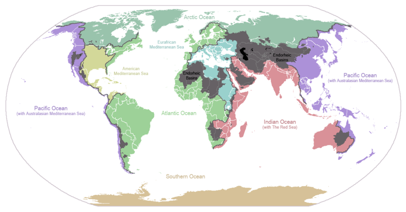
English: I made this map and hereby release it into the public domain. It shows the drainage basins for the major oceans and seas; grey areas are endorheic basins that do not drain to the ocean. Data is from the USGS Hydro1k project; information for Saskatchewan corrected by information from the Commission for Environmental Cooperation -- Citynoise
Description in large font size is used for oceans, in smaller font size is used for mediterranean seas. Only these mediterranean seas are listed which correspond to the definition of german Geographer Ernst Neef: A mediterranean sea is a sea between two Continents. Also found here: de:Mittelmeer --W like wiki (talk) 00:55, 12 March 2011 (UTC)
Français : Carte du monde des bassins versants. Les zones de couleur anthracite représentent les bassins endoréiques, qui ne sont reliés à aucun océan.
Čeština: Úmoří světových oceánů, popř. významných moří či zálivů. Legenda úmoří: fialová - Tichý oceán, růžová - Indický oceán, zelená - Atlantický oceán, azurová - Severní ledový oceán, béžová - Jižní oceán, modrá - Mexický záliv, světle modrá - Středozemní moře, šedá - oblast neústící ve světovém oceánu
تریخ ۲۴ جنوری ۲۰۰۷ (original upload date)
سروت Transferred from en.wikipedia to Commons.
لکھاری Citynoise at English وکیپیڈیا
دوجے ورژن File:Major endorheic basins.png

لائسنس –

Public domain اس کم نوں لوکاں لئی ایدے لکھاریCitynoise at English وکیپیڈیا نے دے دتا اے، اے سارے جگ واسطے لاگو اے۔
کج ملکاں چ قانونی طور تے اے ممکن نئیں اے؛ اگر انج ای اے ے:
Citynoise ہر کسے نوں اس کم نوں کسے وی مقصد واسطے ورتن دا بغیر کسے شرط دے حق دیندا واں، اگر اوہ قانون دے خلاف نا ہوۓ۔

پہلا اپلوڈ دا ریکارڈ

The original description page was here. All following user names refer to en.wikipedia.
  • 2007-05-20 17:59 Bolonium 1256×656×8 (50194 bytes) I made this map and hereby release it into the public domain. It shows the drainage basins for the major oceans and seas; grey areas are endorheic basins that do not drain to the ocean. -- [[User:Citynoise|Citynoise]] == Licensing == {{self
  • 2007-01-24 07:21 Citynoise 1256×656×8 (63359 bytes) I made this map and hereby release it into the public domain. It shows the drainage basins for the major oceans and seas; grey areas are endorheic basins that do not drain to the ocean.
  • 2007-01-24 06:09 Citynoise 1256×656×8 (57358 bytes) I made this map and hereby release it into the public domain. It shows the drainage basins for the major oceans and seas; grey areas are endorheic basins that do not drain to the ocean.
  • 2007-01-24 05:10 Citynoise 1256×656×8 (56360 bytes) I made this map and hereby release it into the public domain. It shows the drainage basins for the major oceans and seas; grey areas are endorheic basins that do not drain to the ocean.
  • 2007-01-24 04:55 Citynoise 1256×656×8 (56373 bytes) I made this map and hereby release it into the public domain. It shows the drainage basins for the major oceans and seas; grey areas are endorheic basins that do not drain to the ocean.

Captions

Add a one-line explanation of what this file represents
Drainage basins of the world, colored by ocean outlet. Endorheic basins not draining to an ocean are colored dark gray. Continental divides are indicated by dark lines.

Items portrayed in this file

چترن

۲۴ جنوری 2007

فائل دی تریخ

فائل نو اس ویلے دی حالت وچ ویکھن واسطے تاریخ/ویلے تے کلک کرو۔

تریخ تے ویلہنکی مورتپاسےورتن والاتیپّݨی کرو
موجودہ۰۴:۲۵, ۷ اکتوبر ۲۰۱۵۰۴:۲۵, ۷ اکتوبر ۲۰۱۵ ویلے دے ورژن ساتھ انگوٹھاکار روپ۱,۲۵۶ × ۶۵۶ (۷۵ کلوبائٹ)AcidSnowFixed Somalia.
۰۵:۳۹, ۱۲ مارچ ۲۰۱۱۰۵:۳۹, ۱۲ مارچ ۲۰۱۱ ویلے دے ورژن ساتھ انگوٹھاکار روپ۱,۲۵۶ × ۶۵۶ (۷۶ کلوبائٹ)W like wikiInsert Description. Big font size is used for oceans, smaller font size is used for mediterranean seas.
۱۶:۱۳, ۳۰ جون ۲۰۰۹۱۶:۱۳, ۳۰ جون ۲۰۰۹ ویلے دے ورژن ساتھ انگوٹھاکار روپ۱,۲۵۶ × ۶۵۶ (۴۰ کلوبائٹ)U7vGuntransparentize background,improve some details.
۰۱:۴۵, ۲۷ جولائی ۲۰۰۸۰۱:۴۵, ۲۷ جولائی ۲۰۰۸ ویلے دے ورژن ساتھ انگوٹھاکار روپ۱,۲۵۶ × ۶۵۶ (۶۲ کلوبائٹ)Citynoise{{Information |Description=added endorheic basins in Saskatchewan. |Source=my own work |Date=July 2008 |Author=Citynoise |Permission=all rights released |other_versions= }}
۰۰:۴۶, ۲۸ نومبر ۲۰۰۷۰۰:۴۶, ۲۸ نومبر ۲۰۰۷ ویلے دے ورژن ساتھ انگوٹھاکار روپ۱,۲۵۶ × ۶۵۶ (۴۹ کلوبائٹ)File Upload Bot (Magnus Manske) {{BotMoveToCommons|en.wikipedia}} {{Information |Description={{en|I made this map and hereby release it into the public domain. It shows the drainage basins for the major oceans and seas; grey areas are en:endorheic basins that do not drain to the

تھلے دتے گئے 2 صفحے اس فائل نال جُڑدے نیں

فائل ویاپک ورتوں

ایہہ دوجے وکیاں ایس فائل نوں ورتدے نیں –

ایس فائل دا ویکھو ہور جگت ورتن .

میٹا ڈیٹا