
فائل:Oceania ISO 3166-1.svg

Size of this PNG preview of this SVG file: ۷۸۰ × ۵۰۰ پکسلز. دوجے ریزولوشنز: ۳۲۰ × ۲۰۵ پکسلز | ۶۴۰ × ۴۱۰ پکسلز | ۱,۰۲۴ × ۶۵۶ پکسلز | ۱,۲۸۰ × ۸۲۱ پکسلز | ۲,۵۶۰ × ۱,۶۴۱ پکسلز ۔
اصل فائل (ایس وی جی فائل، پکسل:۷۸۰ × ۵۰۰، فائل سائز: ۱۴۶ کلوبائٹ)
خلاصہ
| تفصیل |
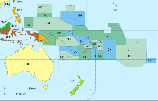
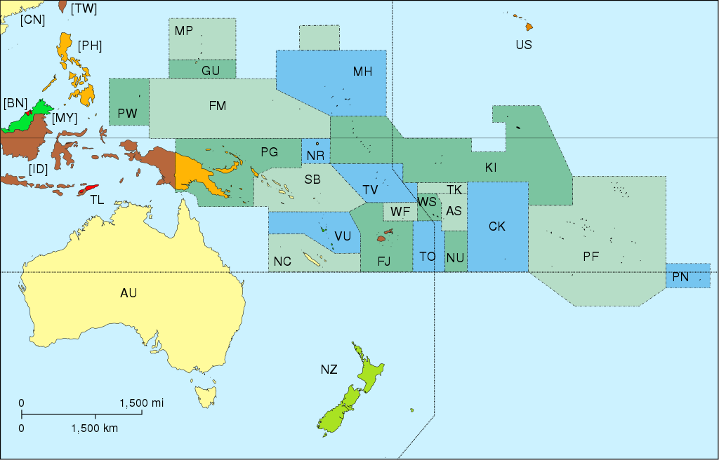
Map of Oceania, with ISO 3166-1 pt · en country and territory code. SVG format. Map legend in Portuguese and English, with name of sovereign state given in parenthesis, where applicable:
On map, but part of Asia:
|
| تریخ | |
| سروت | آپݨا کم |
| لکھاری | Júlio Reis |
| دوجے ورژن |
|


لائسنس –
ایس فائل نوں کریٹو کامنز Attribution 2.5 پولینڈ لائسنس دتا گیا.
- تہانوں کھلھ اے:
- حصہ کرنا – کاپی، ونڈنا تے کم بھیجنا
- فیر رلانا – کم نوں فٹ کرنا
- تھلے دتیاں شرطاں نال:
- کس دے ناں – تسیں لازمی ایس کم دے بناں والے بارے دسو جنج اونے آکھیا اے یا جنج لسنس چ آکھیا گیا ہے۔
- اکو جہا شئیر کرو۔ – اگر تسیں بدلدے یا ایس کم تے بناندے تے بنن والے کم نوں اینج دے لسنس نال ای ونڈو گے۔
derivative works
Derivative works of this file: Oceania blank.svg
فائل دی تریخ
فائل نو اس ویلے دی حالت وچ ویکھن واسطے تاریخ/ویلے تے کلک کرو۔
| تریخ تے ویلہ | نکی مورت | پاسے | ورتن والا | تیپّݨی کرو | |
|---|---|---|---|---|---|
| موجودہ | ۲۲:۴۵, ۷ نومبر ۲۰۱۵ | | ۷۸۰ × ۵۰۰ (۱۴۶ کلوبائٹ) | BurritoBazooka | getting rid of transparent border around map |
| ۲۱:۵۰, ۲۵ مارچ ۲۰۱۴ |  | ۸۰۰ × ۵۲۰ (۱۴۵ کلوبائٹ) | Knyaz-1988 | New version | |
| ۲۱:۴۹, ۲۵ مارچ ۲۰۱۴ |  | ۸۰۰ × ۵۲۰ (۱۶۲ کلوبائٹ) | Knyaz-1988 | Reverted to version as of 04:23, 21 December 2007 | |
| ۰۹:۲۴, ۲۱ دسمبر ۲۰۰۷ |  | ۸۰۰ × ۵۲۰ (۱۶۲ کلوبائٹ) | ButterStick | ||
| ۰۹:۲۳, ۲۱ دسمبر ۲۰۰۷ |  | ۸۰۰ × ۵۲۰ (۱۶۲ کلوبائٹ) | ButterStick | ||
| ۰۹:۲۱, ۲۱ دسمبر ۲۰۰۷ |  | ۸۰۰ × ۵۲۰ (۱۶۲ کلوبائٹ) | ButterStick | Code optimization | |
| ۱۸:۳۵, ۳۰ مئی ۲۰۰۶ |  | ۸۰۰ × ۵۲۰ (۲۳۸ کلوبائٹ) | Tintazul | {{Tintazul| |Description=Map of Oceania, with ISO 3166-1 <sup>pt · en</sup> country and territory code. SVG format. Map legend in Portuguese and English, with name of sovereign state given in parenthesis, where appl |
فائل دی ورتوں
اس فائل نال جڑیا کوئی صفحہ نئیں۔
فائل ویاپک ورتوں
ایہہ دوجے وکیاں ایس فائل نوں ورتدے نیں –
- ace.wikipedia.org تے ورتوں
- ar.wikipedia.org تے ورتوں
- as.wikipedia.org تے ورتوں
- bat-smg.wikipedia.org تے ورتوں
- cs.wikipedia.org تے ورتوں
- de.wikipedia.org تے ورتوں
- de.wiktionary.org تے ورتوں
- diq.wikipedia.org تے ورتوں
- en.wikipedia.org تے ورتوں
- es.wikipedia.org تے ورتوں
- et.wikipedia.org تے ورتوں
- fa.wikipedia.org تے ورتوں
- gd.wikipedia.org تے ورتوں
- gl.wikipedia.org تے ورتوں
- gl.wikiquote.org تے ورتوں
- ia.wikipedia.org تے ورتوں
ایس فائل دا ویکھو ہور جگت ورتن .