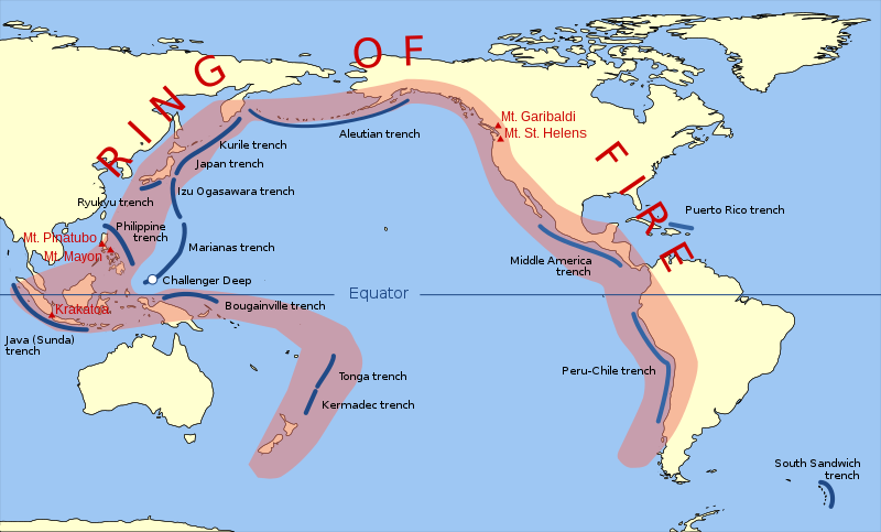
فائل:Pacific Ring of Fire.svg

Size of this PNG preview of this SVG file: ۸۰۰ × ۴۸۳ پکسلز. دوجے ریزولوشنز: ۳۲۰ × ۱۹۳ پکسلز | ۶۴۰ × ۳۸۷ پکسلز | ۱,۰۲۴ × ۶۱۹ پکسلز | ۱,۲۸۰ × ۷۷۳ پکسلز | ۲,۵۶۰ × ۱,۵۴۶ پکسلز | ۹۴۲ × ۵۶۹ پکسلز ۔
اصل فائل (ایس وی جی فائل، پکسل:۹۴۲ × ۵۶۹، فائل سائز: ۲۹۴ کلوبائٹ)
فائل دی تریخ
فائل نو اس ویلے دی حالت وچ ویکھن واسطے تاریخ/ویلے تے کلک کرو۔
| تریخ تے ویلہ | نکی مورت | پاسے | ورتن والا | تیپّݨی کرو | |
|---|---|---|---|---|---|
| موجودہ | ۱۶:۳۰, ۲۰ مارچ ۲۰۱۵ |  | ۹۴۲ × ۵۶۹ (۲۹۴ کلوبائٹ) | Szczureq | Ryuku → Ryukyu |
| ۱۸:۱۹, ۱۵ مارچ ۲۰۱۱ |  | ۹۴۲ × ۵۶۹ (۲۹۴ کلوبائٹ) | AnonMoos | trimming transparent margins | |
| ۰۰:۲۵, ۴ مارچ ۲۰۰۹ |  | ۷۹۶ × ۴۷۲ (۳۱۴ کلوبائٹ) | Kmusser | Fix volanco symbols | |
| ۰۰:۰۴, ۴ مارچ ۲۰۰۹ |  | ۷۹۶ × ۴۷۲ (۳۱۷ کلوبائٹ) | Kmusser | repositioned volcanoes | |
| ۰۴:۲۴, ۱۴ فروری ۲۰۰۹ |  | ۷۸۱ × ۴۷۲ (۱۴۵ کلوبائٹ) | Inductiveload | added volcanos | |
| ۲۲:۱۸, ۱۱ فروری ۲۰۰۹ |  | ۷۸۱ × ۴۷۲ (۱۳۸ کلوبائٹ) | Inductiveload | added labels, aluetian isles and south sandwich islands, as these are associated with the nearby trenches. also put everything into layers. | |
| ۰۴:۵۸, ۱۱ فروری ۲۰۰۹ |  | ۷۸۱ × ۴۷۲ (۱۱۱ کلوبائٹ) | Gringer | Resized image 3x so that nominal size is reasonable in default Wikipedia image display. | |
| ۰۴:۵۲, ۱۱ فروری ۲۰۰۹ |  | ۲۶۰ × ۱۵۷ (۱۱۲ کلوبائٹ) | Gringer | {{Information |Description={{en|1=SVG version of File:Pacific_Ring_of_Fire.png, recreated by me using WDB vector data using code mentioned in File:Worldmap_wdb_combined.svg.}} |Source=vector data from [http://www.evl.uic.edu/pape/data/WDB/] |Aut |
فائل دی ورتوں
تھلے دتے گئے 1 صفحے اس فائل نال جُڑدے نیں
فائل ویاپک ورتوں
ایہہ دوجے وکیاں ایس فائل نوں ورتدے نیں –
- af.wikipedia.org تے ورتوں
- ar.wikipedia.org تے ورتوں
- ast.wikipedia.org تے ورتوں
- ban.wikipedia.org تے ورتوں
- bcl.wikipedia.org تے ورتوں
- bg.wikipedia.org تے ورتوں
- bn.wikipedia.org تے ورتوں
- bs.wikipedia.org تے ورتوں
- da.wikipedia.org تے ورتوں
- el.wikipedia.org تے ورتوں
- en.wikipedia.org تے ورتوں
- en.wikibooks.org تے ورتوں
- en.wikivoyage.org تے ورتوں
- en.wiktionary.org تے ورتوں
- es.wikipedia.org تے ورتوں
- fa.wikipedia.org تے ورتوں
- fi.wikipedia.org تے ورتوں
- he.wikipedia.org تے ورتوں
- hi.wikipedia.org تے ورتوں
- hu.wikipedia.org تے ورتوں
- ilo.wikipedia.org تے ورتوں
- incubator.wikimedia.org تے ورتوں
- is.wikipedia.org تے ورتوں
- is.wikibooks.org تے ورتوں
- it.wikibooks.org تے ورتوں
- ja.wikipedia.org تے ورتوں
- ja.wikibooks.org تے ورتوں
- jv.wikipedia.org تے ورتوں
- ka.wikipedia.org تے ورتوں
- kk.wikipedia.org تے ورتوں
- la.wikipedia.org تے ورتوں
ایس فائل دا ویکھو ہور جگت ورتن .


