
فائل:Peloponnese Middle Ages map-en.svg

Size of this PNG preview of this SVG file: ۷۶۶ × ۶۰۰ پکسلز. دوجے ریزولوشنز: ۳۰۷ × ۲۴۰ پکسلز | ۶۱۳ × ۴۸۰ پکسلز | ۹۸۱ × ۷۶۸ پکسلز | ۱,۲۸۰ × ۱,۰۰۲ پکسلز | ۲,۵۶۰ × ۲,۰۰۵ پکسلز | ۱,۷۸۵ × ۱,۳۹۸ پکسلز ۔
اصل فائل (ایس وی جی فائل، پکسل:۱,۷۸۵ × ۱,۳۹۸، فائل سائز: ۲.۰۴ میگابائٹ)
| تفصیل |
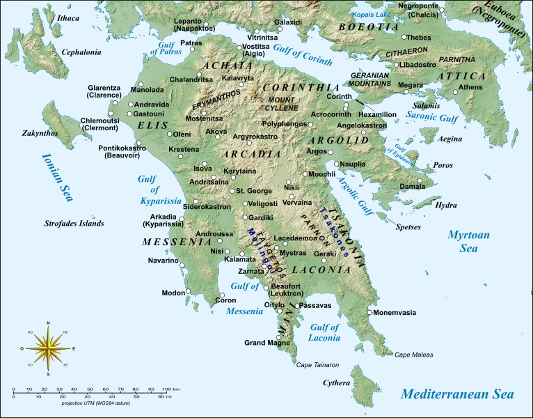
English: Map of Peloponnese, Greece, with the sites of major importance during the Middle Ages.
Français : Carte du Péloponnèse, Grèce, avec principaux sites du Moyen Âge. UTM projection; WGS84 datum |
| تریخ | (UTC) |
| سروت | |
| لکھاری |
|
| دوجے ورژن |
|


| This is a retouched picture, which means that it has been digitally altered from its original version. Modifications: English version, added more sites. The original can be viewed here: Peloponnese Middle Ages map-fr.svg:
|
میں، اس کم دے کاپیرائٹ دا مالک، اس کم نوں اس لائسنس دے مطابق چھاپدا واں:
ایہ فائل ایس لسنس Creative Commons Attribution-Share Alike 3.0 Unported, 2.5 Generic, 2.0 Generic and 1.0 Generic نال چلدی اے۔
- تہانوں کھلھ اے:
- حصہ کرنا – کاپی، ونڈنا تے کم بھیجنا
- فیر رلانا – کم نوں فٹ کرنا
- تھلے دتیاں شرطاں نال:
- کس دے ناں – تسیں لازمی ایس کم دے بناں والے بارے دسو جنج اونے آکھیا اے یا جنج لسنس چ آکھیا گیا ہے۔
- اکو جہا شئیر کرو۔ – اگر تسیں بدلدے یا ایس کم تے بناندے تے بنن والے کم نوں اینج دے لسنس نال ای ونڈو گے۔

|
کاپی کرن، ونڈن تے بدلن دی ایس ڈوکومنٹ لئی اجازت دتی جاندی اے ایہناں GNU Free Documentation License, Version 1.2 شرطاں نال یا مگروں کسے وی چھپے ورین Free Software Foundation توں بنا کسے انویرینٹ سیکشن دے، ناں فرنٹ کور لکھت تے ناں بیک کور لکھت دے۔ لسنس دی اک کاپی سیکشن وچ ہیگی اے جہدا ناں اے GNU Free Documentation License۔ |
تسیں اپنی مرضی دا لائسنس چݨ سکدے اوہ۔
پہلا اپلوڈ دا ریکارڈ
This image is a derivative work of the following images:
- File:Peloponnese_Middle_Ages_map-fr.svg licensed with Cc-by-sa-3.0,2.5,2.0,1.0, GFDL
- 2008-04-07T20:18:41Z Sting 1785x1398 (1175068 Bytes) Bigger labels
- 2008-04-04T20:27:23Z Sting 1785x1398 (1175530 Bytes) {{Information |Description={{en|Map of [[:en:Peloponnese|Peloponnese]], Greece, with major places of the Middle Ages.}} {{fr|Carte du [[:fr:Péloponnèse|Péloponnèse]], Grèce, avec principaux sites du Moyen Âge.}} |Source
Uploaded with derivativeFX
فائل دی تریخ
فائل نو اس ویلے دی حالت وچ ویکھن واسطے تاریخ/ویلے تے کلک کرو۔
| تریخ تے ویلہ | نکی مورت | پاسے | ورتن والا | تیپّݨی کرو | |
|---|---|---|---|---|---|
| موجودہ | ۱۶:۰۲, ۲۴ فروری ۲۰۱۴ | | ۱,۷۸۵ × ۱,۳۹۸ (۲.۰۴ میگابائٹ) | Cplakidas | various minor tweaks, added approx. location of Grand Magne text to paths |
| ۱۸:۳۵, ۱۷ اگست ۲۰۱۲ |  | ۱,۷۸۵ × ۱,۳۹۸ (۱.۱۶ میگابائٹ) | Phso2 | Minor changes : typos, anticised modern names in brackets, duplicate Pylos/Navarin | |
| ۲۲:۱۳, ۱۰ مئی ۲۰۱۰ |  | ۱,۷۸۵ × ۱,۳۹۸ (۱.۱۶ میگابائٹ) | Cplakidas | various tweaks with names, added the Hexamilion wall | |
| ۱۵:۳۶, ۲۱ اپریل ۲۰۱۰ |  | ۱,۷۸۵ × ۱,۳۹۸ (۱.۱۶ میگابائٹ) | Cplakidas | bolded city names to make them more discernible | |
| ۱۵:۲۱, ۲۱ اپریل ۲۰۱۰ |  | ۱,۷۸۵ × ۱,۳۹۸ (۱.۱۵ میگابائٹ) | Cplakidas | {{Information |Description={{en|Map of Peloponnese, Greece, with the sites of major importance during the Middle Ages.}} {{fr|Carte du Péloponnèse, Grèce, avec principaux sites du Moyen Âge.}}<br/> UTM proje |
فائل دی ورتوں
اس فائل نال جڑیا کوئی صفحہ نئیں۔
فائل ویاپک ورتوں
ایہہ دوجے وکیاں ایس فائل نوں ورتدے نیں –
- azb.wikipedia.org تے ورتوں
- ca.wikipedia.org تے ورتوں
- cs.wikipedia.org تے ورتوں
- de.wikipedia.org تے ورتوں
- el.wikipedia.org تے ورتوں
- en.wikipedia.org تے ورتوں
- Constantine XI Palaiologos
- Principality of Achaea
- Morea
- Lordship of Argos and Nauplia
- Las (Greece)
- Battle of the Olive Grove of Kountouras
- William of Champlitte
- Geoffrey I of Villehardouin
- Skorta
- Nerio I Acciaioli
- Chlemoutsi
- Glarentza
- Ottoman–Venetian War (1463–1479)
- Morea revolt of 1453–1454
- Leo Sgouros
- Ezeritai
- Melingoi
- Battle of Prinitza
- Battle of Makryplagi
- User:Cplakidas/Articles
- Battle of the Echinades (1427)
- Barony of Vostitsa
- Barony of Patras
- Barony of Akova
- Barony of Passavant
- Barony of Geraki
ایس فائل دا ویکھو ہور جگت ورتن .