
فائل:Ph Territorial Map.png

ایس وکھالے دا ناپ: ۵۸۴ × ۶۰۰ پکسلز۔ دوجے ریزولوشنز: ۲۳۴ × ۲۴۰ پکسلز | ۴۶۷ × ۴۸۰ پکسلز | ۷۴۸ × ۷۶۸ پکسلز | ۹۹۷ × ۱,۰۲۴ پکسلز | ۱,۸۲۷ × ۱,۸۷۷ پکسلز ۔
اصل فائل (۱,۸۲۷ × ۱,۸۷۷ پکسلز, فائل حجم: ۶۱۲ کلوبائٹ, MIME type: image/png)

|
This map image could be re-created using vector graphics as an SVG file. This has several advantages; see Commons:Media for cleanup for more information. If an SVG form of this image is available, please upload it and afterwards replace this template with
{{vector version available|new image name}}.
It is recommended to name the SVG file “Ph Territorial Map.svg”—then the template Vector version available (or Vva) does not need the new image name parameter. |
خلاصہ
| تفصیل |
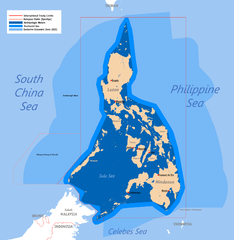
English: Territorial map claimed by the Philippines, showing internal waters, territorial sea, international treaty limits and exclusive economic zone. |
| تریخ | ۲۵ جون ۲۰۰۷ (original upload) |
| سروت | English Wikipedia (log) |
| لکھاری | Roel Balingit (username: Namayan); addition of Benham Rise and Indo-PH EEZs: Ervin Malicdem (schadow1) |
لائسنس –
Roel Balingit (username: Namayan)، اس کم دے کاپیرائٹ دا مالک، اس کم نوں اس لائسنس دے مطابق چھاپدا واں:

|
کاپی کرن، ونڈن تے بدلن دی ایس ڈوکومنٹ لئی اجازت دتی جاندی اے ایہناں GNU Free Documentation License, Version 1.2 شرطاں نال یا مگروں کسے وی چھپے ورین Free Software Foundation توں بنا کسے انویرینٹ سیکشن دے، ناں فرنٹ کور لکھت تے ناں بیک کور لکھت دے۔ لسنس دی اک کاپی سیکشن وچ ہیگی اے جہدا ناں اے GNU Free Documentation License۔ |
اے فائل ایس لائسنس تھلے آندی اے Creative Commons Attribution 1.0 Generic .
کس دے ناں: Roel Balingit (username: Namayan)
- تہانوں کھلھ اے:
- حصہ کرنا – کاپی، ونڈنا تے کم بھیجنا
- فیر رلانا – کم نوں فٹ کرنا
- تھلے دتیاں شرطاں نال:
- کس دے ناں – تسیں لازمی ایس کم دے بناں والے بارے دسو جنج اونے آکھیا اے یا جنج لسنس چ آکھیا گیا ہے۔
تسیں اپنی مرضی دا لائسنس چݨ سکدے اوہ۔
فائل دی تریخ
فائل نو اس ویلے دی حالت وچ ویکھن واسطے تاریخ/ویلے تے کلک کرو۔
| تریخ تے ویلہ | نکی مورت | پاسے | ورتن والا | تیپّݨی کرو | |
|---|---|---|---|---|---|
| موجودہ | ۱۰:۵۸, ۱۹ جولائی ۲۰۱۵ | | ۱,۸۲۷ × ۱,۸۷۷ (۶۱۲ کلوبائٹ) | Schadow1 | Extending EEZ boundaries to include Benham Rise Extended EEZ and Philippines-Indonesia EEZ Delimitation Agreement |
| ۱۶:۳۳, ۸ مئی ۲۰۱۲ |  | ۱,۸۲۷ × ۱,۷۹۰ (۵۳۵ کلوبائٹ) | Sky Harbor | Reverted to version as of 16:54, 28 August 2009. The name "West Philippine Sea" is a neologism and is not neutral. | |
| ۱۳:۱۳, ۴ مئی ۲۰۱۲ |  | ۶۱۲ × ۶۰۰ (۱۲۹ کلوبائٹ) | Jeromesandilanico | Change of name as West Philippine Sea as used to describe the Philippines official claim as used by the Philippine Government and Media. | |
| ۲۱:۵۴, ۲۸ اگست ۲۰۰۹ |  | ۱,۸۲۷ × ۱,۷۹۰ (۵۳۵ کلوبائٹ) | Mormegil | {{Information |Description= {{en|Territorial map of the Philippines, showing internal waters, territorial sea, international treaty limits and exclusive economic zone.}} |Source=English Wikipedia |Date={{date|2007-0 |
فائل دی ورتوں
تھلے دتے گئے 1 صفحے اس فائل نال جُڑدے نیں
فائل ویاپک ورتوں
ایہہ دوجے وکیاں ایس فائل نوں ورتدے نیں –
- af.wikipedia.org تے ورتوں
- bn.wikipedia.org تے ورتوں
- cs.wikipedia.org تے ورتوں
- de.wikipedia.org تے ورتوں
- en.wikipedia.org تے ورتوں
- Scarborough Shoal
- User:Namayan
- Philippines and the Spratly Islands
- Wikipedia talk:Tambayan Philippines/Archive 16
- Spratly Islands dispute
- Wikipedia:Graphics Lab/Map workshop/Archive/Apr 2013
- Wikipedia:Graphics Lab/Map workshop/Archive/May 2014
- Baselines of the Philippines
- Borders of the Philippines
- User:TagaSanPedroAko/Original contents of Presidency of Rodrigo Duterte
- User:Jose Edmundo Dayot/PIL Module 4
- fr.wikipedia.org تے ورتوں
- gl.wikipedia.org تے ورتوں
- he.wikipedia.org تے ورتوں
- he.wiktionary.org تے ورتوں
- ilo.wikipedia.org تے ورتوں
- io.wikipedia.org تے ورتوں
- it.wikipedia.org تے ورتوں
- ja.wikipedia.org تے ورتوں
- ka.wikipedia.org تے ورتوں
- km.wikipedia.org تے ورتوں
- kn.wikipedia.org تے ورتوں
- mdf.wikipedia.org تے ورتوں
- pa.wikipedia.org تے ورتوں
- pl.wikipedia.org تے ورتوں
- sk.wikipedia.org تے ورتوں
- th.wikipedia.org تے ورتوں
- tl.wikipedia.org تے ورتوں
- uk.wikipedia.org تے ورتوں
ایس فائل دا ویکھو ہور جگت ورتن .