
فائل:Population density of Ireland map2002.svg

Size of this PNG preview of this SVG file: ۴۸۰ × ۶۰۰ پکسلز. دوجے ریزولوشنز: ۱۹۲ × ۲۴۰ پکسلز | ۳۸۴ × ۴۸۰ پکسلز | ۶۱۴ × ۷۶۸ پکسلز | ۸۱۹ × ۱,۰۲۴ پکسلز | ۱,۶۳۸ × ۲,۰۴۸ پکسلز ۔
اصل فائل (ایس وی جی فائل، پکسل:۸۰۰ × ۱,۰۰۰، فائل سائز: ۶۲۱ کلوبائٹ)
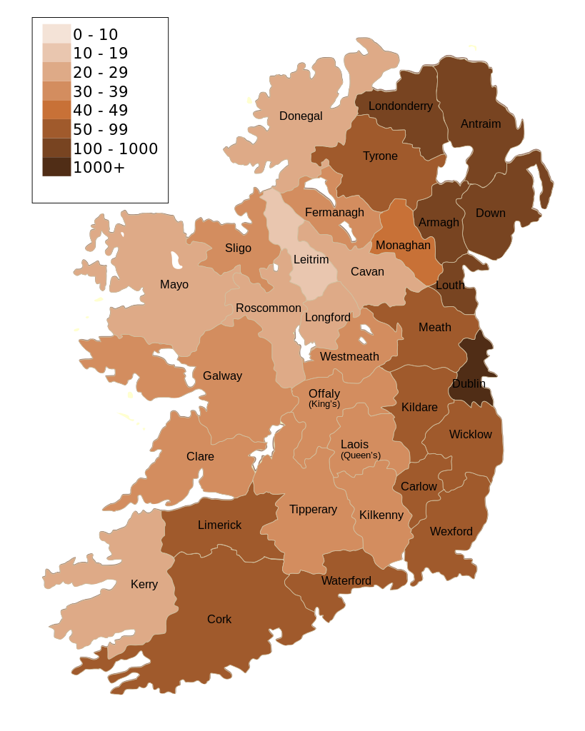
| تفصیل | Map of Ireland's population density (people per km2). Based upon Republic of Ireland - 2002 Census results. |
| تریخ | (UTC) |
| سروت | |
| لکھاری |
|
| دوجے ورژن | Derivative works of this file: Population density of Ireland map2002 RU.svg |
| This is a retouched picture, which means that it has been digitally altered from its original version. Modifications: Map of Ireland's population density (people per km2). Based upon Republic of Ireland - 2002 Census results.. The original can be viewed here: Ireland complete.svg:
|
میں، اس کم دے کاپیرائٹ دا مالک، اس کم نوں اس لائسنس دے مطابق چھاپدا واں:
| میں، اس کم دے کاپیرائٹ دا مالک، اس کم نوں لوکاں واسطے دیندا واں۔ اے سارے جگ واسطے لاگو اے۔ کج ملکاں چ قانونی طور تے اے ممکن نئیں اے؛ اگر انج ای اے ے: میں ہر کسے نوں اس کم نوں کسے وی مقصد واسطے ورتن دا بغیر کسے شرط دے حق دیندا واں، اگر اوہ قانون دے خلاف نا ہوۓ۔ |
پہلا اپلوڈ دا ریکارڈ
This image is a derivative work of the following images:
- File:Ireland_complete.svg licensed with PD-self
- 2007-06-23T17:06:44Z Future Perfect at Sunrise 800x1000 (594536 Bytes) {{Information |Description= |Source=self-made |Date= |Author= [[User:Future Perfect at Sunrise|Future Perfect at Sunrise]] }}
- 2007-06-23T16:45:52Z Future Perfect at Sunrise 800x1000 (590003 Bytes) {{Information |Description= |Source=self-made |Date= |Author= [[User:Future Perfect at Sunrise|Future Perfect at Sunrise]] }}
- 2007-06-23T16:35:48Z Future Perfect at Sunrise 2000x2500 (606764 Bytes) {{Information |Description=SVG map of Ireland. |Source=self-made |Date=23 June 2007 |Author= [[User:Future Perfect at Sunrise|Future Perfect at Sunrise]] }} Note: the SVG code contains separate levels showing boundaries and
Uploaded with derivativeFX
فائل دی تریخ
فائل نو اس ویلے دی حالت وچ ویکھن واسطے تاریخ/ویلے تے کلک کرو۔
| تریخ تے ویلہ | نکی مورت | پاسے | ورتن والا | تیپّݨی کرو | |
|---|---|---|---|---|---|
| موجودہ | ۱۹:۳۰, ۱۷ اکتوبر ۲۰۰۹ | | ۸۰۰ × ۱,۰۰۰ (۶۲۱ کلوبائٹ) | The Illusional Ministry | Dublin now in black text |
| ۱۹:۲۷, ۱۷ اکتوبر ۲۰۰۹ |  | ۸۰۰ × ۱,۰۰۰ (۶۲۱ کلوبائٹ) | The Illusional Ministry | {{Information |Description=Map of Ireland's population density (people per km2). Based upon Republic of Ireland - 2002 Census results. |Source=*File:Ireland_complete.svg |Date=2009-10-17 14:25 (UTC) |Author=*File:Ireland_complete.svg: '''Futur |
فائل دی ورتوں
اس فائل نال جڑیا کوئی صفحہ نئیں۔
فائل ویاپک ورتوں
ایہہ دوجے وکیاں ایس فائل نوں ورتدے نیں –
- de.wikipedia.org تے ورتوں
- gv.wikipedia.org تے ورتوں
- he.wikipedia.org تے ورتوں
- hu.wikipedia.org تے ورتوں
- kn.wikipedia.org تے ورتوں
- sd.wikipedia.org تے ورتوں
- te.wikipedia.org تے ورتوں