
فائل:SE2015Mar20T.png

ایس وکھالے دا ناپ: ۵۹۹ × ۶۰۰ پکسلز۔ دوجے ریزولوشنز: ۲۴۰ × ۲۴۰ پکسلز | ۴۷۹ × ۴۸۰ پکسلز | ۷۲۸ × ۷۲۹ پکسلز ۔
اصل فائل (۷۲۸ × ۷۲۹ پکسلز, فائل حجم: ۲۷ کلوبائٹ, MIME type: image/png)
خلاصہ
| تفصیل |
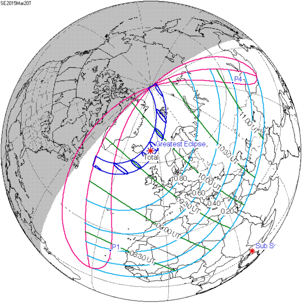
English: Solar eclipse A map of path on earth: Totality exists within the dark blue areas, partiality at the light blue areas. The eclipse occurs at sunrise or sunset in the pink areas. Light blue lines represent a constant fixed fraction of coverage. Green lines show lines of time for greatest coverage. For more information see [1] |
| تریخ | |
| سروت | http://eclipse.gsfc.nasa.gov/ |
| لکھاری | Eclipse Predictions by Fred Espenak, NASA's GSFC |
![[1]](http://eclipse.gsfc.nasa.gov/SEplot/SEplot2001/SE2015Mar20T.GIF)
لائسنس –
| This file is in the public domain in the United States because it was solely created by NASA. NASA copyright policy states that "NASA material is not protected by copyright unless noted". (See Template:PD-USGov, NASA copyright policy page or JPL Image Use Policy.) | ||
 |
Warnings:
|
پہلا اپلوڈ دا ریکارڈ
The original description page was here. All following user names refer to en.wikipedia.
- 2009-12-08 20:37 SockPuppetForTomruen 728×729× (91056 bytes)
- 2009-11-22 07:43 Tomruen 733×729× (91478 bytes) {{Information |Description = [[Solar eclipse]] map of path on earth |Source = http://eclipse.gsfc.nasa.gov/ |Date = 2000 |Author = Fred |Permission = Official work for NASA |other_versions = }} {{Attribution}} Attribution: '''Eclipse Pr
فائل دی تریخ
فائل نو اس ویلے دی حالت وچ ویکھن واسطے تاریخ/ویلے تے کلک کرو۔
| تریخ تے ویلہ | نکی مورت | پاسے | ورتن والا | تیپّݨی کرو | |
|---|---|---|---|---|---|
| موجودہ | ۲۳:۲۲, ۱۶ جولائی ۲۰۱۵ | | ۷۲۸ × ۷۲۹ (۲۷ کلوبائٹ) | Cmdrjameson | Compressed with pngout. Reduced by 62kB (70% decrease). |
| ۱۳:۴۰, ۹ اگست ۲۰۱۱ |  | ۷۲۸ × ۷۲۹ (۸۹ کلوبائٹ) | OgreBot | (BOT): Reverting to most recent version; originally uploaded at en.wikipedia on 2009-12-08 20:37:41 by SockPuppetForTomruen | |
| ۱۳:۴۰, ۹ اگست ۲۰۱۱ |  | ۷۳۳ × ۷۲۹ (۸۹ کلوبائٹ) | OgreBot | (BOT): Uploading old version of file from en.wikipedia; originally uploaded on 2009-11-22 07:43:35 by Tomruen | |
| ۱۵:۱۳, ۱۳ مارچ ۲۰۱۱ |  | ۷۲۸ × ۷۲۹ (۸۹ کلوبائٹ) | SamZane | {{Information |Description ={{en|1=Solar eclipse of march 20 2015 map.}} |Source =NASA |Author =NASA |Date = |Permission = |other_versions = }} Category:Solar eclipse map |
فائل دی ورتوں
تھلے دتے گئے 1 صفحے اس فائل نال جُڑدے نیں
فائل ویاپک ورتوں
ایہہ دوجے وکیاں ایس فائل نوں ورتدے نیں –
- ar.wikipedia.org تے ورتوں
- كسوف الشمس 20 مارس 2015
- كسوف الشمس 1 يونيو 2011
- كسوف الشمس 1 سبتمبر 2016
- كسوف الشمس 26 فبراير 2017
- كسوف الشمس 25 أكتوبر 2022
- كسوف الشمس 12 أغسطس 2026
- كسوف الشمس 30 مارس 2033
- كسوف الشمس 5 يناير 2038
- كسوف الشمس 25 أكتوبر 2041
- كسوف الشمس 12 أغسطس 2045
- كسوف الشمس 31 مايو 2049
- كسوف الشمس 11 أبريل 2051
- كسوف الشمس 20 مارس 2034
- كسوف الشمس 20 مارس 2053
- كسوف الشمس 12 أغسطس 2064
- كسوف الشمس 5 يناير 2057
- كسوف الشمس 24 أكتوبر 2060
- كسوف الشمس 31 مايو 2068
- كسوف الشمس 21 أبريل 2069
- كسوف الشمس 6 يناير 2019
- كسوف الشمس 2 مايو 2087
- كسوف الشمس 1 يونيو 2087
- كسوف الشمس 19 مارس 2072
- كسوف الشمس 7 فبراير 2073
- كسوف الشمس 3 أغسطس 2073
- كسوف الشمس 27 يناير 2074
- كسوف الشمس 6 يناير 2076
- كسوف الشمس 24 أكتوبر 2079
- كسوف الشمس 21 مارس 2080
- كسوف الشمس 13 سبتمبر 2080
- كسوف الشمس 10 مارس 2081
- كسوف الشمس 13 أغسطس 2083
- كسوف الشمس 7 يناير 2084
- كسوف الشمس 3 يوليو 2084
- كسوف الشمس 27 ديسمبر 2084
- كسوف الشمس 22 يونيو 2085
- كسوف الشمس 16 ديسمبر 2085
- az.wikipedia.org تے ورتوں
- be.wikipedia.org تے ورتوں
- bg.wikipedia.org تے ورتوں
- bn.wikipedia.org تے ورتوں
- el.wikipedia.org تے ورتوں
- en.wikipedia.org تے ورتوں
ایس فائل دا ویکھو ہور جگت ورتن .