
فائل:Saudi map of Persian gulf - 1952.jpg

اس توں وڈی مورت موجود نہیں۔
Saudi_map_of_Persian_gulf_-_1952.jpg (۶۲۳ × ۴۴۲ پکسلز, فائل حجم: ۸۱ کلوبائٹ, MIME type: image/jpeg)
| تفصیل |
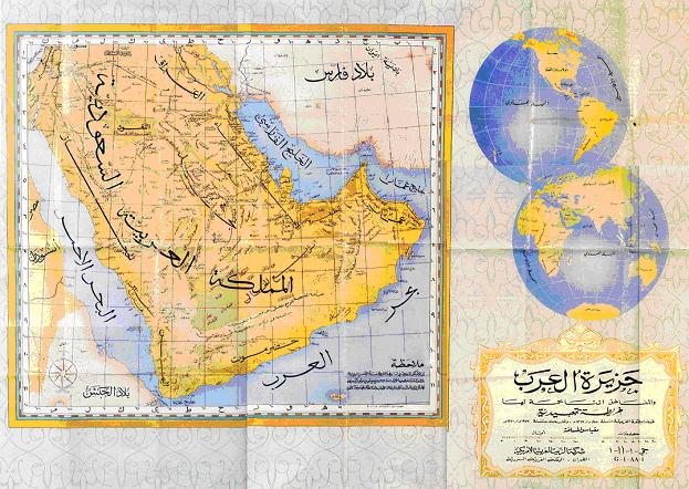
English: Saudi Arabian Map of 1952 displaying the correct name for the Persian Gulf.
فارسی: نقشهٔ عربستان سعودی از خلیج فارس، مربوط به سال ۱۹۵۲ میلادی که نام درست خلیج فارس را نشان میدهد. |
||||||||||||||||||||||||
| تریخ | |||||||||||||||||||||||||
| سروت | http://www.kavehfarrokh.com/wp-content/uploads/2009/02/map-of-persian-gulf-published-by-saudi-arabia-19523.jpg | ||||||||||||||||||||||||
| لکھاری | The government of Saudi Arabia | ||||||||||||||||||||||||
| اجازت (فائل نوں دوبارہ ورتنا) |
|
||||||||||||||||||||||||

فائل دی تریخ
فائل نو اس ویلے دی حالت وچ ویکھن واسطے تاریخ/ویلے تے کلک کرو۔
| تریخ تے ویلہ | نکی مورت | پاسے | ورتن والا | تیپّݨی کرو | |
|---|---|---|---|---|---|
| موجودہ | ۲۳:۲۲, ۲۰ مارچ ۲۰۰۹ | | ۶۲۳ × ۴۴۲ (۸۱ کلوبائٹ) | David Trochos | |
| ۱۴:۰۲, ۲۶ فروری ۲۰۰۹ |  | ۶۲۳ × ۴۴۲ (۸۱ کلوبائٹ) | Wayiran | {{Information |Description={{en|1=Saudi Arabian Map of 1952 displaying the correct name for the Persian Gulf.}} {{fa|1=نقشهٔ عربستان سعودی از خلیج فارس، مربوط به سال ۱۹۵۲ میلادی که نام درست خلیج |
فائل دی ورتوں
تھلے دتے گئے 1 صفحے اس فائل نال جُڑدے نیں
فائل ویاپک ورتوں
ایہہ دوجے وکیاں ایس فائل نوں ورتدے نیں –
- ar.wikipedia.org تے ورتوں
- ar.wikinews.org تے ورتوں
- arz.wikipedia.org تے ورتوں
- fa.wikipedia.org تے ورتوں
- tr.wikipedia.org تے ورتوں
- ur.wikipedia.org تے ورتوں