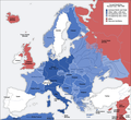
فائل:Second world war europe 1941-1942 map en.png

Page contents not supported in other languages.
آزاد انسائیکلوپیڈیا، وکیپیڈیا توں

اصل فائل(۱,۰۹۰ × ۱,۰۰۰ پکسلز, فائل حجم: ۲۱۶ کلوبائٹ, MIME type: image/png)

ایہ فائل Wikimedia Commons توں اے تے دوجیاں ویونتاں تے وی ورتی جاسکدی اے۔ گل بات اس دے فائل گل بات صفحہ تے تھلے دتی گئی۔

This military map image could be re-created using vector graphics as an SVG file. This has several advantages; see Commons:Media for cleanup for more information. If an SVG form of this image is available, please upload it and afterwards replace this template with {{vector version available|new image name}}.


It is recommended to name the SVG file “Second world war europe 1941-1942 map en.svg”—then the template Vector version available (or Vva) does not need the new image name parameter.
Maps of the history of Europe
BCE
aC

Weichselian ice age (c. 113,000–9700) · Neolithic expansion (c. 7000–4500) · Middle Neolithic (c. 4500–4000) · Late Neolithic (c. 4000–3000) · Copper Age – Corded Ware culture (c. 2900–2350) · Copper Age – Bellbeaker culture (c. 2800–1800) · Early Bronze Age – Unetice culture (c. 2300–1600) · Late Bronze Age – Urnfield culture (c. 1300—750) · Migrations (c. 1000–100) · Hallstatt & La Tène cultures (c. 800–100) · Roman Republic (510–40) · 220 · 218 · 200 · 201–100 · 58 · 49 · 39 · 30 BCE–6 CE


CE
dC

14 · 14–37 · 60 · 60 · 69 · 80 · Migrations 100–500 · 117 · 117 · 125 · Migrations 150–774 · Economy 180 · 271 · 293–305 · 337 · 395 · c. 395 · 400 · 400 · 450 · 457–61 · 476 · 480 · Franks 481–814 · Early Slavs 500–700 · 500 · 526 · 526–600 · Christianisation to 600 · c. 550 · 650 · Pontic Steppe 650 · 665 · 800 · Vikings 800–1050 · 814 · 843–70 · 850 · 900 · 912 · 998 · 1000 · 1000 · 1054 · 1092 · First Crusade 1095–99 · 1097 · 1135 · 1142 · 1147–49 · 1190 · 1190 · 1250 · c. 1250 · 1301-1400 · 1301-1400 · 1328 · 1345 · Black Plague 1347–51 · 1360 · 1400 · Trade routes c. 1400 · 1430 · 1470 · 1490 · 1492 · 1500 · 1519 · 1550 · 1560 · Religion 1560 · Religion 1600 · Religion 1618 · 1618–48 · 1648 · 1683 · 1700 · 1701 · 1708 · 1714 · 1721 · 1725–30 · 1739–1740 · 1740 · 1748–66 · 1783–1792 · 1787 · 1787 · 1789 · 1799 · 1812 · 1812 · 1812 · 1812 · 1813 · 1815 · 1815 · 1815 · 1818 · Ottoman Empire 1830–1923 · 1848–49 · 1861 · 1867 · 1871 · 1878 · 1890 · 1905 · 1911 · 1914 · 1914 · 1919 · 1919–29 · 1923 · 1929 · 1930 · 1940 · 1941–42 · 1942–45 · Cold War 1947–91 · 1950 · 1993–2006 · 2006 to date

(this template: · view · discuss )

خلاصہ

Annotations
InfoField
This image is annotated: View the annotations at Commons
تفصیل
Deutsch: Karte der vom Deutschen Reich besetzten Gebiete und der Kriegsfronten im Zweiten Weltkrieg, 1941/42.
English: A map of German front of the Second World War circa 1941-1942.
Ελληνικά: Εδαφικές κατακτήσεις του Ράιχ
Español: Conquistas territoriales del Reich
تریخ Original Image: 17 April 2005
Derivative Image: 22 December 2005
سروت This file was derived from: Second world war europe 1941-1942 map de.png
لکھاری Original Author: User:San Jose
Derivative Author: User:ArmadniGeneral
اجازت
(فائل نوں دوبارہ ورتنا)
This image is a translation of the original, created and released under the terms of the GNU Free Documentation License.
دوجے ورژن

Derivative works of this file:  Großdeutsches Reich-europe.png [سودھو]

لائسنس –

GNU head کاپی کرن، ونڈن تے بدلن دی ایس ڈوکومنٹ ل‏ئی اجازت دتی جاندی اے ایہناں GNU Free Documentation License, Version 1.2 شرطاں نال یا مگروں کسے وی چھپے ورین Free Software Foundation توں بنا کسے انویرینٹ سیکشن دے، ناں فرنٹ کور لکھت تے ناں بیک کور لکھت دے۔ لسنس دی اک کاپی سیکشن وچ ہیگی اے جہدا ناں اے GNU Free Documentation License۔
w:en:Creative Commons
کس دے ناں اکو جہا شئیر کرو۔
ایس فائل نوں کریٹو کامنز Attribution 2.5 پولینڈ لائسنس دتا گیا.
تہانوں کھلھ اے:
  • حصہ کرنا – کاپی، ونڈنا تے کم بھیجنا
  • فیر رلانا – کم نوں فٹ کرنا
تھلے دتیاں شرطاں نال:
  • کس دے ناں – تسیں لازمی ایس کم دے بناں والے بارے دسو جنج اونے آکھیا اے یا جنج لسنس چ آکھیا گیا ہے۔
  • اکو جہا شئیر کرو۔ – اگر تسیں بدلدے یا ایس کم تے بناندے تے بنن والے کم نوں اینج دے لسنس نال ای ونڈو گے۔
اس لائسنس دا ٹیگ GFDL دے مطابق اس فائل چ پایا گیا اے licensing update۔

Captions

Add a one-line explanation of what this file represents

Items portrayed in this file

چترن

copyrighted English

media type English

image/png

فائل دی تریخ

فائل نو اس ویلے دی حالت وچ ویکھن واسطے تاریخ/ویلے تے کلک کرو۔

تریخ تے ویلہنکی مورتپاسےورتن والاتیپّݨی کرو
موجودہ۲۱:۲۰, ۵ اگست ۲۰۲۰۲۱:۲۰, ۵ اگست ۲۰۲۰ ویلے دے ورژن ساتھ انگوٹھاکار روپ۱,۰۹۰ × ۱,۰۰۰ (۲۱۶ کلوبائٹ)Claude ZygielDistinguished statutes
۰۶:۰۰, ۲۸ جولائی ۲۰۱۸۰۶:۰۰, ۲۸ جولائی ۲۰۱۸ ویلے دے ورژن ساتھ انگوٹھاکار روپ۱,۰۹۰ × ۱,۰۰۰ (۱۸۴ کلوبائٹ)JeffyPShrinking file size
۱۳:۰۶, ۱۶ فروری ۲۰۰۹۱۳:۰۶, ۱۶ فروری ۲۰۰۹ ویلے دے ورژن ساتھ انگوٹھاکار روپ۱,۰۹۰ × ۱,۰۰۰ (۲۱۴ کلوبائٹ)Guinnog{{Information |Description=better titles |Source=*File:Second_world_war_europe_1941-1942_map_en.png |Date=2009-02-16 08:05 (UTC) |Author=*File:Second_world_war_europe_1941-1942_map_en.png: Sir Lothar *derivative work: ~~~ |Permission=see below
۰۵:۲۲, ۱۱ اپریل ۲۰۰۸۰۵:۲۲, ۱۱ اپریل ۲۰۰۸ ویلے دے ورژن ساتھ انگوٹھاکار روپ۱,۰۹۰ × ۱,۰۰۰ (۲۰۸ کلوبائٹ)Sir Lothar
۱۰:۳۶, ۲۱ دسمبر ۲۰۰۵۱۰:۳۶, ۲۱ دسمبر ۲۰۰۵ ویلے دے ورژن ساتھ انگوٹھاکار روپ۱,۰۹۰ × ۱,۰۰۰ (۲۲۱ کلوبائٹ)ArmadniGeneralA map of the Eastern front of the Second World War circa 1941-1942. The original German-language map was created by User:San Jose on 17 April 2005. It can be found here: Image:Second world war europe 1941-1942 map de.png. This image is a translat

تھلے دتے گئے 1 صفحے اس فائل نال جُڑدے نیں

فائل ویاپک ورتوں

ایہہ دوجے وکیاں ایس فائل نوں ورتدے نیں –

ایس فائل دا ویکھو ہور جگت ورتن .
میٹا ڈیٹا