
فائل:Spread sugarcane.JPG
Spread_sugarcane.JPG (۴۸۳ × ۲۴۸ پکسلز, فائل حجم: ۱۶ کلوبائٹ, MIME type: image/jpeg)

|
This map image could be re-created using vector graphics as an SVG file. This has several advantages; see Commons:Media for cleanup for more information. If an SVG form of this image is available, please upload it and afterwards replace this template with
{{vector version available|new image name}}.
It is recommended to name the SVG file “Spread sugarcane.svg”—then the template Vector version available (or Vva) does not need the new image name parameter. |


خلاصہ
| تفصیل |
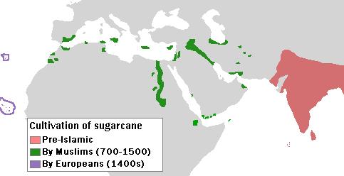
English: Author: User:Bless_sins.
Source: I saw this map in:
Use rationale: I made it myself. The template map was free-use.
(islands west of Africa, circled by violet lines) |
| تریخ | ۱۰ اپریل ۲۰۰۸ (original upload date) |
| سروت |
Transferred from en.wikipedia to Commons by Teratornis using CommonsHelper.
Cambridge University Press. p. 16. |
| لکھاری | Bless sins at English وکیپیڈیا |
لائسنس –
- تہانوں کھلھ اے:
- حصہ کرنا – کاپی، ونڈنا تے کم بھیجنا
- فیر رلانا – کم نوں فٹ کرنا
- تھلے دتیاں شرطاں نال:
- کس دے ناں – تسیں لازمی ایس کم دے بناں والے بارے دسو جنج اونے آکھیا اے یا جنج لسنس چ آکھیا گیا ہے۔
- اکو جہا شئیر کرو۔ – اگر تسیں بدلدے یا ایس کم تے بناندے تے بنن والے کم نوں اینج دے لسنس نال ای ونڈو گے۔
پہلا اپلوڈ دا ریکارڈ
- 2008-04-10 04:58 Bless sins 483×248× (16233 bytes) Author: User:Bless_sins. Source: I saw this map in: Watson, Andrew. ''Agricultural innovation in the early Islamic world''. [[Cambridge University Press]]. p. 16. Looking at it I drew an approximation. Use rationale: I made it myself. The template map was
فائل دی تریخ
فائل نو اس ویلے دی حالت وچ ویکھن واسطے تاریخ/ویلے تے کلک کرو۔
| تریخ تے ویلہ | نکی مورت | پاسے | ورتن والا | تیپّݨی کرو | |
|---|---|---|---|---|---|
| موجودہ | ۱۰:۳۲, ۷ اکتوبر ۲۰۰۹ | | ۴۸۳ × ۲۴۸ (۱۶ کلوبائٹ) | File Upload Bot (Magnus Manske) | {{BotMoveToCommons|en.wikipedia|year={{subst:CURRENTYEAR}}|month={{subst:CURRENTMONTHNAME}}|day={{subst:CURRENTDAY}}}} {{Information |Description={{en|Author: User:Bless_sins. Source: I saw this map in: Watson, Andrew. ''Agricultural innovation in the ea |
فائل دی ورتوں
تھلے دتے گئے 1 صفحے اس فائل نال جُڑدے نیں
فائل ویاپک ورتوں
ایہہ دوجے وکیاں ایس فائل نوں ورتدے نیں –
- cs.wikipedia.org تے ورتوں
- el.wikipedia.org تے ورتوں
- en.wikipedia.org تے ورتوں
- eo.wikipedia.org تے ورتوں
- es.wikipedia.org تے ورتوں
- eu.wikipedia.org تے ورتوں
- fr.wikipedia.org تے ورتوں
- he.wikipedia.org تے ورتوں
- hr.wikipedia.org تے ورتوں
- hu.wikipedia.org تے ورتوں
- ja.wikipedia.org تے ورتوں
- kn.wikipedia.org تے ورتوں
- ko.wikipedia.org تے ورتوں
- pa.wikipedia.org تے ورتوں
- pt.wikipedia.org تے ورتوں
- sh.wikipedia.org تے ورتوں
- sr.wikipedia.org تے ورتوں