
فائل:Suez Canal, Port Said - ISS 2.jpg

ایس وکھالے دا ناپ: ۸۰۰ × ۵۸۵ پکسلز۔ دوجے ریزولوشنز: ۳۲۰ × ۲۳۴ پکسلز | ۶۴۰ × ۴۶۸ پکسلز | ۱,۰۲۴ × ۷۴۹ پکسلز | ۱,۲۸۰ × ۹۳۷ پکسلز | ۲,۷۴۴ × ۲,۰۰۸ پکسلز ۔
اصل فائل (۲,۷۴۴ × ۲,۰۰۸ پکسلز, فائل حجم: ۲.۵۴ میگابائٹ, MIME type: image/jpeg)
خلاصہ
| تفصیل |
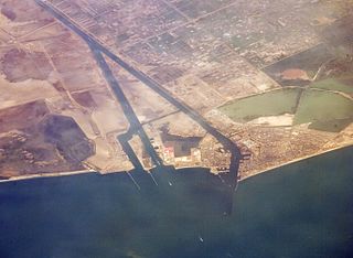
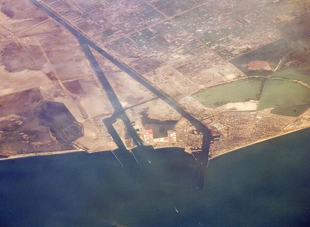
English: Port Said and the entrance to the Suez Canal. Photographed from the International Space Station.
|
| تریخ | |
| سروت | http://eol.jsc.nasa.gov/SearchPhotos/photo.pl?mission=ISS013&roll=E&frame=44847 |
| لکھاری | NASA astronaut |
| دوجے ورژن |

پہلا اپلوڈ دا ریکارڈ
Gebruiker Ajoman, 10 aug 2006 20:55 1.000x750, description:Monding Suez kanaal. Afkomstig van NASA. June 30, 2006, source: suez)
لائسنس –
This file is in the public domain in the United States because it was created by the Image Science & Analysis Laboratory, of the NASA Johnson Space Center. NASA copyright policy states that "NASA material is not protected by copyright unless noted". (NASA media use guidelines or Conditions of Use of Astronaut Photographs).
Photo source: ISS013-E-44847.
|
فائل دی تریخ
فائل نو اس ویلے دی حالت وچ ویکھن واسطے تاریخ/ویلے تے کلک کرو۔
| تریخ تے ویلہ | نکی مورت | پاسے | ورتن والا | تیپّݨی کرو | |
|---|---|---|---|---|---|
| موجودہ | ۲۰:۱۹, ۱۳ جولائی ۲۰۱۶ | | ۲,۷۴۴ × ۲,۰۰۸ (۲.۵۴ میگابائٹ) | Ras67 | new rendered from NASA's raw image data in high quality |
| ۱۶:۳۹, ۲۶ جولائی ۲۰۰۸ |  | ۱,۰۰۰ × ۷۵۰ (۲۸۷ کلوبائٹ) | Dryke | {{Information |Description=Port Said and the entrance to the Suez Canal. Photographed from the International Space Station. |Source={{AstronautPhoto|mission=ISS013|roll=E|frame=44847}} |Date=30 June 2006 |Author=unnamed N |
فائل دی ورتوں
تھلے دتے گئے 1 صفحے اس فائل نال جُڑدے نیں
فائل ویاپک ورتوں
ایہہ دوجے وکیاں ایس فائل نوں ورتدے نیں –
- ar.wikipedia.org تے ورتوں
- ast.wikipedia.org تے ورتوں
- ceb.wikipedia.org تے ورتوں
- de.wikipedia.org تے ورتوں
- el.wikipedia.org تے ورتوں
- en.wikipedia.org تے ورتوں
- en.wikivoyage.org تے ورتوں
- es.wikipedia.org تے ورتوں
- eu.wikipedia.org تے ورتوں
- fa.wikipedia.org تے ورتوں
- fr.wikipedia.org تے ورتوں
- he.wikipedia.org تے ورتوں
- hu.wikipedia.org تے ورتوں
- ja.wikipedia.org تے ورتوں
- ja.wikivoyage.org تے ورتوں
- ko.wikipedia.org تے ورتوں
- mt.wikipedia.org تے ورتوں
- ne.wikipedia.org تے ورتوں
- nl.wikipedia.org تے ورتوں
- nn.wikipedia.org تے ورتوں
- pl.wikipedia.org تے ورتوں
- pt.wikipedia.org تے ورتوں
- sh.wikipedia.org تے ورتوں
- sr.wikipedia.org تے ورتوں
- sv.wikipedia.org تے ورتوں
- uk.wikivoyage.org تے ورتوں
- ur.wikipedia.org تے ورتوں