
فائل:The Red Corridor ver 1.PNG
اس توں وڈی مورت موجود نہیں۔
The_Red_Corridor_ver_1.PNG (۵۳۰ × ۵۹۹ پکسلز, فائل حجم: ۱۴۶ کلوبائٹ, MIME type: image/png)
خلاصہ
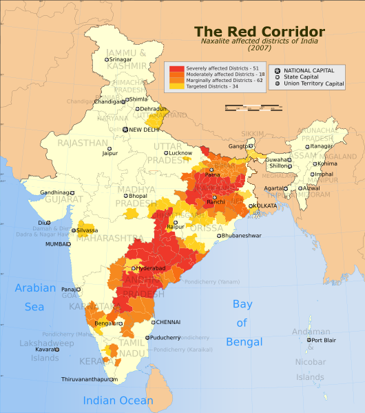
| تفصیل | The Red Corridor. A relatively underdeveloped region in eastern India that has w:Naxalite communist militant activity. |
| تریخ | (UTC) |
| سروت | |
| لکھاری |
|
| This is a retouched picture, which means that it has been digitally altered from its original version. The original can be viewed here: India Red Corridor map.png:
|
میں، اس کم دے کاپیرائٹ دا مالک، اس کم نوں اس لائسنس دے مطابق چھاپدا واں:
ایس فائل نوں کریٹو کامنز Attribution 2.5 پولینڈ لائسنس دتا گیا.
- تہانوں کھلھ اے:
- حصہ کرنا – کاپی، ونڈنا تے کم بھیجنا
- فیر رلانا – کم نوں فٹ کرنا
- تھلے دتیاں شرطاں نال:
- کس دے ناں – تسیں لازمی ایس کم دے بناں والے بارے دسو جنج اونے آکھیا اے یا جنج لسنس چ آکھیا گیا ہے۔
- اکو جہا شئیر کرو۔ – اگر تسیں بدلدے یا ایس کم تے بناندے تے بنن والے کم نوں اینج دے لسنس نال ای ونڈو گے۔

|
کاپی کرن، ونڈن تے بدلن دی ایس ڈوکومنٹ لئی اجازت دتی جاندی اے ایہناں GNU Free Documentation License, Version 1.2 شرطاں نال یا مگروں کسے وی چھپے ورین Free Software Foundation توں بنا کسے انویرینٹ سیکشن دے، ناں فرنٹ کور لکھت تے ناں بیک کور لکھت دے۔ لسنس دی اک کاپی سیکشن وچ ہیگی اے جہدا ناں اے GNU Free Documentation License۔ |
تسیں اپنی مرضی دا لائسنس چݨ سکدے اوہ۔
پہلا اپلوڈ دا ریکارڈ
This image is a derivative work of the following images:
- File:India_Red_Corridor_map.png licensed with Cc-by-sa-3.0, GFDL
- 2008-10-27T17:01:57Z Hunnjazal 530x599 (378273 Bytes) {{Information |Description=The Red Corridor. A relatively underdeveloped region in eastern India that has [[w:Naxalite]] communist militant activity. |Source=*[[:Image:India_Naxal_affected_districts_map
فائل دی تریخ
فائل نو اس ویلے دی حالت وچ ویکھن واسطے تاریخ/ویلے تے کلک کرو۔
| تریخ تے ویلہ | نکی مورت | پاسے | ورتن والا | تیپّݨی کرو | |
|---|---|---|---|---|---|
| موجودہ | ۱۱:۱۵, ۳۱ اکتوبر ۲۰۰۹ | | ۵۳۰ × ۵۹۹ (۱۴۶ کلوبائٹ) | Gagan11111 | {{Information |Description=The Red Corridor. A relatively underdeveloped region in eastern India that has w:Naxalite communist militant activity. |Source=*File:India_Red_Corridor_map.png |Date=2009-10-31 06:14 (UTC) |Author=*[[:File:India_Red_Co |
فائل دی ورتوں
تھلے دتے گئے 1 صفحے اس فائل نال جُڑدے نیں
فائل ویاپک ورتوں
ایہہ دوجے وکیاں ایس فائل نوں ورتدے نیں –
- ar.wikipedia.org تے ورتوں
- cs.wikipedia.org تے ورتوں
- en.wikipedia.org تے ورتوں
- es.wikipedia.org تے ورتوں
- fr.wikipedia.org تے ورتوں
- mr.wikipedia.org تے ورتوں
- pt.wikipedia.org تے ورتوں
- ta.wikipedia.org تے ورتوں
- www.wikidata.org تے ورتوں
- zh.wikipedia.org تے ورتوں