
فائل:Tibet provinces.png
ایس وکھالے دا ناپ: ۸۰۰ × ۵۵۵ پکسلز۔ دوجے ریزولوشنز: ۳۲۰ × ۲۲۲ پکسلز | ۶۴۰ × ۴۴۴ پکسلز | ۱,۰۲۴ × ۷۱۱ پکسلز | ۱,۴۲۱ × ۹۸۶ پکسلز ۔
اصل فائل (۱,۴۲۱ × ۹۸۶ پکسلز, فائل حجم: ۸۷۱ کلوبائٹ, MIME type: image/png)
| تفصیل |
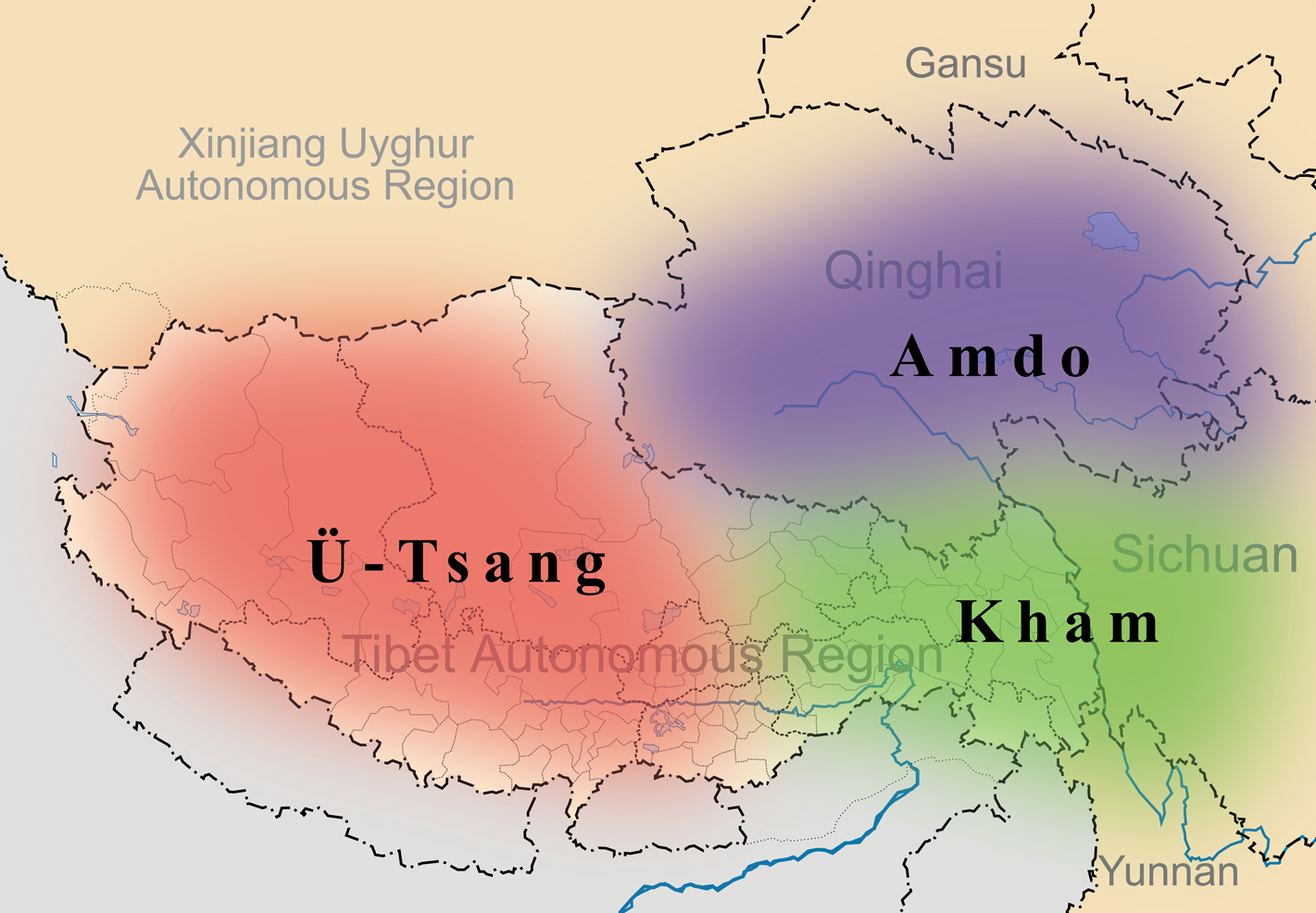
English: A simple map of the three traditional provinces of Tibet overlaid on a map of modern provincial boundaries of the People's Republic of China. |
| تریخ | (UTC) |
| سروت | |
| لکھاری |
|
| This is a retouched picture, which means that it has been digitally altered from its original version. Modifications: added traditional provinces overlay. The original can be viewed here: Map of Tibet Ü-Tsang Amdo and Kham.jpg:
|
ایس فائل نوں کریٹو کامنز Attribution 2.5 پولینڈ لائسنس دتا گیا.
- تہانوں کھلھ اے:
- حصہ کرنا – کاپی، ونڈنا تے کم بھیجنا
- فیر رلانا – کم نوں فٹ کرنا
- تھلے دتیاں شرطاں نال:
- کس دے ناں – تسیں لازمی ایس کم دے بناں والے بارے دسو جنج اونے آکھیا اے یا جنج لسنس چ آکھیا گیا ہے۔
- اکو جہا شئیر کرو۔ – اگر تسیں بدلدے یا ایس کم تے بناندے تے بنن والے کم نوں اینج دے لسنس نال ای ونڈو گے۔
پہلا اپلوڈ دا ریکارڈ
This image is a derivative work of the following images:
- File:Tibet&neighbors_Locator_map.svg licensed with Cc-by-sa-3.0, GFDL
- 2009-10-13T22:22:54Z Keithonearth 1520x1059 (188220 Bytes) {{Information |Description={{en|1=A simple map of the Tibetan Autonomous Region, and surrounding Nations, and States. It was made for [[:en:Template:Location map China Tibet]].}} |Source={{own}} |Author=[[User:Keithonearth|K
- File:Map_of_Tibet_Ü-Tsang_Amdo_and_Kham.jpg licensed with Cc-by-sa-2.5
Uploaded with derivativeFX
فائل دی تریخ
فائل نو اس ویلے دی حالت وچ ویکھن واسطے تاریخ/ویلے تے کلک کرو۔
| تریخ تے ویلہ | نکی مورت | پاسے | ورتن والا | تیپّݨی کرو | |
|---|---|---|---|---|---|
| موجودہ | ۰۲:۳۵, ۲۸ مارچ ۲۰۱۱ | | ۱,۴۲۱ × ۹۸۶ (۸۷۱ کلوبائٹ) | Kmusser | {{Information |Description={{en|1=A simple map of the three traditional provinces of Tibet overlaid on a map of modern provincial boundaries of the People's Republic of China.}} == |Source=*File:Tibet&neighbors_Locator_map.svg *[[:File:Map_of_Tibet_ |
فائل دی ورتوں
تھلے دتے گئے 1 صفحے اس فائل نال جُڑدے نیں
فائل ویاپک ورتوں
ایہہ دوجے وکیاں ایس فائل نوں ورتدے نیں –
- ast.wikipedia.org تے ورتوں
- bg.wikipedia.org تے ورتوں
- bn.wikipedia.org تے ورتوں
- cdo.wikipedia.org تے ورتوں
- cs.wikipedia.org تے ورتوں
- da.wikipedia.org تے ورتوں
- de.wikipedia.org تے ورتوں
- diq.wikipedia.org تے ورتوں
- en.wikipedia.org تے ورتوں
- en.wikivoyage.org تے ورتوں
- en.wiktionary.org تے ورتوں
- eo.wikipedia.org تے ورتوں
- es.wikipedia.org تے ورتوں
- et.wikipedia.org تے ورتوں
- eu.wikipedia.org تے ورتوں
- fa.wikipedia.org تے ورتوں
- fr.wikipedia.org تے ورتوں
- fr.wiktionary.org تے ورتوں
- ga.wikipedia.org تے ورتوں
- hi.wikipedia.org تے ورتوں
- hu.wikipedia.org تے ورتوں
ایس فائل دا ویکھو ہور جگت ورتن .