
فائل:TorresStraitIslandsMap.png

ایس وکھالے دا ناپ: ۶۰۴ × ۵۹۹ پکسلز۔ دوجے ریزولوشنز: ۲۴۲ × ۲۴۰ پکسلز | ۴۸۴ × ۴۸۰ پکسلز | ۹۲۹ × ۹۲۲ پکسلز ۔
اصل فائل (۹۲۹ × ۹۲۲ پکسلز, فائل حجم: ۲۸ کلوبائٹ, MIME type: image/png)
خلاصہ

|
This locator map image could be re-created using vector graphics as an SVG file. This has several advantages; see Commons:Media for cleanup for more information. If an SVG form of this image is available, please upload it and afterwards replace this template with
{{vector version available|new image name}}.
It is recommended to name the SVG file “TorresStraitIslandsMap.svg”—then the template Vector version available (or Vva) does not need the new image name parameter. |
| تفصیل |
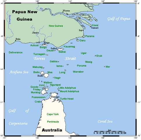
A map of the Torres Strait Islands. I have endeavoured to use native names wherever I could find them. If you can suggest ways in which this map could be made more up to date, don't hesitate to leave me a message to that effect. This map's source is here, with the uploader's modifications, and the GMT homepage says that the tools are released under the GNU General Public License. |
| تریخ | ۱۸ اپریل ۲۰۰۶ (original upload date) |
| سروت | Transferred from en.wikipedia to Commons. |
| لکھاری | Kelisi at English وکیپیڈیا |
| دوجے ورژن | Image:TorresStraitIslandsMap (zh).png |
.png)
لائسنس –
Kelisi from en.wikipedia.org، اس کم دے کاپیرائٹ دا مالک، اس کم نوں اس لائسنس دے مطابق چھاپدا واں:
| ایس فائل نوں کریٹو کامنز Attribution 2.5 پولینڈ لائسنس دتا گیا. Subject to disclaimers. | ||
| کس دے ناں: Kelisi from en.wikipedia.org | ||
| ||
| اس لائسنس دا ٹیگ GFDL دے مطابق اس فائل چ پایا گیا اے licensing update۔ |

|
کاپی کرن، ونڈن تے بدلن دی ایس ڈوکومنٹ لئی اجازت دتی جاندی اے ایہناں GNU Free Documentation License, Version 1.2 شرطاں نال یا مگروں کسے وی چھپے ورین Free Software Foundation توں بنا کسے انویرینٹ سیکشن دے، ناں فرنٹ کور لکھت تے ناں بیک کور لکھت دے۔ لسنس دی اک کاپی سیکشن وچ ہیگی اے جہدا ناں اے GNU Free Documentation License۔ Subject to disclaimers. |
پہلا اپلوڈ دا ریکارڈ
The original description page was here. All following user names refer to en.wikipedia.
- 2006-04-19 00:55 Kelisi 929×922×8 (28510 bytes)
- 2006-04-18 03:38 Kelisi 929×922×8 (28133 bytes) A map of the Torres Strait Islands. I have endeavoured to use native names wherever I could find them. If you can suggest ways in which this map could be made more up to date, don't hesitate to leave me a message to that effect. This map's source is [htt
فائل دی تریخ
فائل نو اس ویلے دی حالت وچ ویکھن واسطے تاریخ/ویلے تے کلک کرو۔
| تریخ تے ویلہ | نکی مورت | پاسے | ورتن والا | تیپّݨی کرو | |
|---|---|---|---|---|---|
| موجودہ | ۱۱:۴۲, ۱۳ جنوری ۲۰۲۲ | | ۹۲۹ × ۹۲۲ (۲۸ کلوبائٹ) | Kelisi | Reverted to version as of 00:09, 1 May 2007 (UTC) Hardly; those two colours are closer to each other. |
| ۲۲:۵۹, ۶ اکتوبر ۲۰۲۱ |  | ۹۲۹ × ۹۲۲ (۳۱ کلوبائٹ) | Claude Zygiel | Better contrast | |
| ۰۵:۰۹, ۱ مئی ۲۰۰۷ |  | ۹۲۹ × ۹۲۲ (۲۸ کلوبائٹ) | Stanmar | {{Information |Description=A map of the Torres Strait Islands. I have endeavoured to use native names wherever I could find them. If you can suggest ways in which this map could be made more up to date, don't hesitate to leave me a message to that effect. |
فائل دی ورتوں
تھلے دتے گئے 1 صفحے اس فائل نال جُڑدے نیں
فائل ویاپک ورتوں
ایہہ دوجے وکیاں ایس فائل نوں ورتدے نیں –
- af.wikipedia.org تے ورتوں
- als.wikipedia.org تے ورتوں
- ar.wikipedia.org تے ورتوں
- azb.wikipedia.org تے ورتوں
- ba.wikipedia.org تے ورتوں
- bg.wikipedia.org تے ورتوں
- bn.wikipedia.org تے ورتوں
- br.wikipedia.org تے ورتوں
- ca.wikipedia.org تے ورتوں
- ceb.wikipedia.org تے ورتوں
- cs.wikipedia.org تے ورتوں
- cy.wikipedia.org تے ورتوں
- da.wikipedia.org تے ورتوں
- de.wikipedia.org تے ورتوں
- Torres-Straße
- Prince-of-Wales-Insel (Queensland)
- Torres-Straits-Expedition
- Bellevue-Inseln
- Mabuiag
- Talbot-Inseln
- Boigu
- Flagge der Torres-Strait-Insulaner
- Manar-Inseln
- Thursday Island
- Horn Island (Torres Strait)
- Saibai
- Thursday-Inseln
- The Three Sisters (Torres Strait)
- Dauan
- Bet Island
- Poll Island
- Sue Island
- Murray-Inseln
- Murray Island
- Badu Island
- Moa Island
- Coconut Island (Australien)
- Yam Island
- Hammond Island
- Goods Island
- Friday Island (Torres Strait)
ایس فائل دا ویکھو ہور جگت ورتن .