
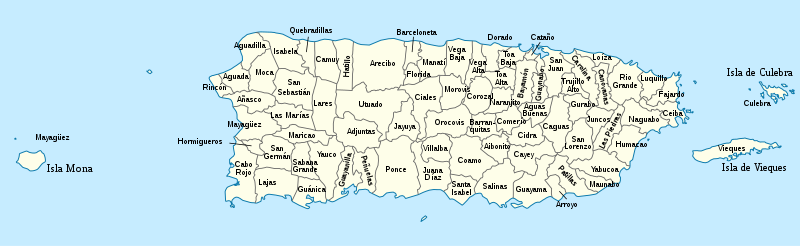
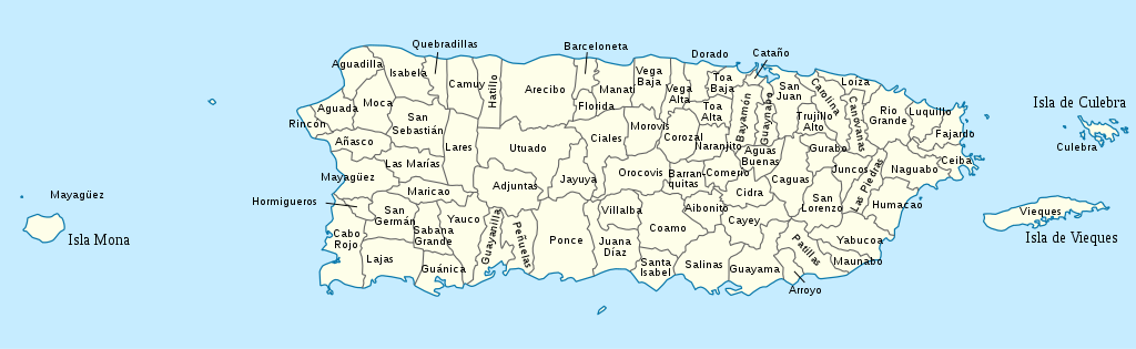
فائل:USA Puerto Rico labeled.svg

Size of this PNG preview of this SVG file: ۸۰۰ × ۲۴۶ پکسلز. دوجے ریزولوشنز: ۳۲۰ × ۹۸ پکسلز | ۶۴۰ × ۱۹۷ پکسلز | ۱,۰۲۴ × ۳۱۵ پکسلز | ۱,۲۸۰ × ۳۹۳ پکسلز | ۲,۵۶۰ × ۷۸۶ پکسلز | ۱,۰۵۸ × ۳۲۵ پکسلز ۔
اصل فائل (ایس وی جی فائل، پکسل:۱,۰۵۸ × ۳۲۵، فائل سائز: ۱۷۱ کلوبائٹ)
خلاصہ


.svg)


_(Paris_zoom).svg)
.svg)
,_administrative_divisions_-_de_-_colored_(multizoom).svg)
_-_colored.svg)
.svg)
,_administrative_divisions_-_Nmbrs_(multizoom).svg)
,_administrative_divisions_-_de_-_colored.svg)
_-_de_-_colored.svg)

.svg)

.svg)
میں، اس کم دے کاپیرائٹ دا مالک، اس کم نوں اس لائسنس دے مطابق چھاپدا واں:
ایس فائل نوں کریٹو کامنز Attribution 2.5 پولینڈ لائسنس دتا گیا.
- تہانوں کھلھ اے:
- حصہ کرنا – کاپی، ونڈنا تے کم بھیجنا
- فیر رلانا – کم نوں فٹ کرنا
- تھلے دتیاں شرطاں نال:
- کس دے ناں – تسیں لازمی ایس کم دے بناں والے بارے دسو جنج اونے آکھیا اے یا جنج لسنس چ آکھیا گیا ہے۔
- اکو جہا شئیر کرو۔ – اگر تسیں بدلدے یا ایس کم تے بناندے تے بنن والے کم نوں اینج دے لسنس نال ای ونڈو گے۔
پہلا اپلوڈ دا ریکارڈ
This image is a derivative work of the following images:
- USA Puerto Rico location map.svg licensed with Cc-by-sa-3.0
- 2009-06-19T07:13:05Z NordNordWest 1058x595 (117123 Bytes) Based on the raster image: [[:Image:Feather.jpg]] * {{Français}} Plume * {{English}} Feather * {{Español}} Pluma == Licensing == {{GFDL-self}} [[Category:Icons]] resizeresizeresizeresizeresizeresizeresizeresizeresize••••
Uploaded with derivativeFX
فائل دی تریخ
فائل نو اس ویلے دی حالت وچ ویکھن واسطے تاریخ/ویلے تے کلک کرو۔
| تریخ تے ویلہ | نکی مورت | پاسے | ورتن والا | تیپّݨی کرو | |
|---|---|---|---|---|---|
| موجودہ | ۲۰:۵۳, ۲۶ مارچ ۲۰۱۰ | ۱,۰۵۸ × ۳۲۵ (۱۷۱ کلوبائٹ) | Kmusser | spelling | |
| ۰۱:۴۴, ۲۵ مارچ ۲۰۱۰ | ۱,۰۵۸ × ۳۲۵ (۱۷۱ کلوبائٹ) | Kmusser | increased font size | ||
| ۰۱:۳۳, ۲۵ مارچ ۲۰۱۰ | ۱,۰۵۸ × ۳۲۵ (۱۷۰ کلوبائٹ) | Kmusser | {{Information |Description={{de|Positionskarte von Puerto Rico, USA}} Quadratische Plattkarte, N-S-Streckung 105 %. Geographische Begrenzung der Karte: * N: 19.0° N * S: 17.5° N * W: 68.0° W * O: 65.2° W {{en|Location m |
فائل دی ورتوں
تھلے دتے گئے 1 صفحے اس فائل نال جُڑدے نیں
فائل ویاپک ورتوں
ایہہ دوجے وکیاں ایس فائل نوں ورتدے نیں –
- de.wikipedia.org تے ورتوں
- en.wikipedia.org تے ورتوں
- es.wikipedia.org تے ورتوں
- fa.wikipedia.org تے ورتوں
- frr.wikipedia.org تے ورتوں
- fr.wikipedia.org تے ورتوں
- is.wikipedia.org تے ورتوں
- it.wikipedia.org تے ورتوں
- ja.wikipedia.org تے ورتوں
- ka.wikipedia.org تے ورتوں
- lt.wikipedia.org تے ورتوں
- nl.wikipedia.org تے ورتوں
- pt.wikipedia.org تے ورتوں
- ru.wikipedia.org تے ورتوں
- su.wikipedia.org تے ورتوں
- th.wikipedia.org تے ورتوں
- trv.wikipedia.org تے ورتوں
- ur.wikipedia.org تے ورتوں
- vi.wikipedia.org تے ورتوں
- zh.wikipedia.org تے ورتوں