فائل:WestBengalDistricts numbered.svg

Page contents not supported in other languages.
آزاد انسائیکلوپیڈیا، وکیپیڈیا توں

اصل فائل(ایس وی جی فائل، پکسل:۷۶۸ × ۱,۱۵۹، فائل سائز: ۳۱۱ کلوبائٹ)

ایہ فائل Wikimedia Commons توں اے تے دوجیاں ویونتاں تے وی ورتی جاسکدی اے۔ گل بات اس دے فائل گل بات صفحہ تے تھلے دتی گئی۔

خلاصہ

تفصیل
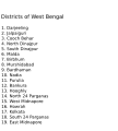
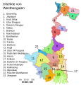
English: Original summary by creator of base svg file deeptrivia. Districts of West Bengal

Based on https://web.archive.org/web/20040606103522/www.censusindia.net/results/2001maps/wbengal01.html

Modifications by Mouryan:

  1. upladed translated version of File:WestBengalDistricts numbered de.svg.
  2. The districts of Dakshin 24 Parganas district and Uttar 24 Parganas were incorrectly numbered in the Map. The errors have been rectified.

Modifications by Furfur:

  1. The 4 (four) new districts of West Bengal namely Paschim Bardhaman district (bifurcated from Bardhaman district), Kalimpong district (bifurcated from Darjeeling district), Alipurduar district (bifurcated from Jalpaiguri district) and Jhargram district (bifurcated from Paschim Medinipur district) has been shown in this new Updated map.

Modifications by Antorjal:

  1. Midnapore District has been bifurcated to show both Paschim Medinipur and Purba Medinipur.
  2. Numbered and listed districts per comments at peer-review.
  3. Font size reduced for clarity, since the districts are now listed.
  4. Many of the spellings did not conform to linked articles in the text. All spellings now match the West Bengal article spellings.
تریخ ۸ اکتوبر ۲۰۰۶ (original upload date)
سروت Transferred from en.wikipedia to Commons by Padawane.
لکھاری The original uploader was Antorjal at English وکیپیڈیا.
دوجے ورژن

[سودھو]

SVG genesis
InfoField
 
The source code of this SVG is invalid due to an error.
 
This W3C-invalid map was created with Adobe Illustrator,
 
and with Inkscape.
 
 This map uses embedded text that can be easily translated using a text editor.

لائسنس –

w:en:Creative Commons
کس دے ناں اکو جہا شئیر کرو۔
ایس فائل نوں Creative Commons Attribution-Share Alike 2.5 Generic, 2.0 Generic and 1.0 Generic لسنس دتا گیا اے۔
تہانوں کھلھ اے:
  • حصہ کرنا – کاپی، ونڈنا تے کم بھیجنا
  • فیر رلانا – کم نوں فٹ کرنا
تھلے دتیاں شرطاں نال:
  • کس دے ناں – تسیں لازمی ایس کم دے بناں والے بارے دسو جنج اونے آکھیا اے یا جنج لسنس چ آکھیا گیا ہے۔
  • اکو جہا شئیر کرو۔ – اگر تسیں بدلدے یا ایس کم تے بناندے تے بنن والے کم نوں اینج دے لسنس نال ای ونڈو گے۔
w:en:Creative Commons
کس دے ناں اکو جہا شئیر کرو۔
ایس فائل نوں کریٹو کامنز Attribution 2.5 پولینڈ لائسنس دتا گیا. Subject to disclaimers.
تہانوں کھلھ اے:
  • حصہ کرنا – کاپی، ونڈنا تے کم بھیجنا
  • فیر رلانا – کم نوں فٹ کرنا
تھلے دتیاں شرطاں نال:
  • کس دے ناں – تسیں لازمی ایس کم دے بناں والے بارے دسو جنج اونے آکھیا اے یا جنج لسنس چ آکھیا گیا ہے۔
  • اکو جہا شئیر کرو۔ – اگر تسیں بدلدے یا ایس کم تے بناندے تے بنن والے کم نوں اینج دے لسنس نال ای ونڈو گے۔
اس لائسنس دا ٹیگ GFDL دے مطابق اس فائل چ پایا گیا اے licensing update۔
GNU head کاپی کرن، ونڈن تے بدلن دی ایس ڈوکومنٹ ل‏ئی اجازت دتی جاندی اے ایہناں GNU Free Documentation License, Version 1.2 شرطاں نال یا مگروں کسے وی چھپے ورین Free Software Foundation توں بنا کسے انویرینٹ سیکشن دے، ناں فرنٹ کور لکھت تے ناں بیک کور لکھت دے۔ لسنس دی اک کاپی سیکشن وچ ہیگی اے جہدا ناں اے GNU Free Documentation License۔ Subject to disclaimers.

پہلا اپلوڈ دا ریکارڈ

The original description page was here. All following user names refer to en.wikipedia.
  • 2006-12-25 04:28 Deeptrivia 450×500×0 (102714 bytes) Repair attempt
  • 2006-12-25 04:17 Deeptrivia 450×500×0 (101044 bytes) Repair attempt
  • 2006-10-08 14:21 Antorjal 450×500×0 (100501 bytes) Original summary by creator of base svg file [[User:deeptrivia|deeptrivia]]. Districts of West Bengal Based on http://web.archive.org/web/20040606103522/www.censusindia.net/results/2001maps/wbengal01.html Modifications by [[User:Antorjal|An
  • 2006-10-08 14:17 Antorjal 450×500×0 (100294 bytes) Original summary by creator of base svg file [[User:deeptrivia|deeptrivia]]. Districts of West Bengal Based on http://web.archive.org/web/20040606103522/www.censusindia.net/results/2001maps/wbengal01.html Modifications by [[User:Antorjal|An
  • 2006-10-08 14:15 Antorjal 450×500×0 (100501 bytes) Original summary by creator of base svg file [[User:deeptrivia|deeptrivia]]. Districts of West Bengal Based on http://web.archive.org/web/20040606103522/www.censusindia.net/results/2001maps/wbengal01.html Modifications by [[User:Antorjal|An
  • 2006-10-08 14:09 Antorjal 450×500×0 (100484 bytes) Original summary by creator of base svg file [[User:deeptrivia|deeptrivia]]. Districts of West Bengal Based on http://web.archive.org/web/20040606103522/www.censusindia.net/results/2001maps/wbengal01.html Modifications by [[User:Antorjal|An
  • 2006-10-08 14:05 Antorjal 450×500×0 (100501 bytes) Original summary by creator of base svg file [[User:deeptrivia|deeptrivia]]. Districts of West Bengal Based on http://web.archive.org/web/20040606103522/www.censusindia.net/results/2001maps/wbengal01.html Modifications by [[User:Antorjal|An

Captions

Add a one-line explanation of what this file represents
Map of West Bengal

Items portrayed in this file

چترن

copyrighted English

۸ اکتوبر 2006

MIME type English

image/svg+xml

فائل دی تریخ

فائل نو اس ویلے دی حالت وچ ویکھن واسطے تاریخ/ویلے تے کلک کرو۔

تریخ تے ویلہنکی مورتپاسےورتن والاتیپّݨی کرو
موجودہ۰۲:۰۴, ۲۶ اپریل ۲۰۲۰۰۲:۰۴, ۲۶ اپریل ۲۰۲۰ ویلے دے ورژن ساتھ انگوٹھاکار روپ۷۶۸ × ۱,۱۵۹ (۳۱۱ کلوبائٹ)Debjitpaul10Updated text
۰۱:۴۵, ۲۶ اپریل ۲۰۲۰۰۱:۴۵, ۲۶ اپریل ۲۰۲۰ ویلے دے ورژن ساتھ انگوٹھاکار روپ۷۶۸ × ۱,۱۵۹ (۱۱۳ کلوبائٹ)Debjitpaul10Uploaded a corrected and transparent version.
۱۱:۱۵, ۵ نومبر ۲۰۱۷۱۱:۱۵, ۵ نومبر ۲۰۱۷ ویلے دے ورژن ساتھ انگوٹھاکار روپ۵۷۶ × ۶۰۱ (۱۴۴ کلوبائٹ)Mouryan{{Information |Description={{en|Original summary by creator of base svg file deeptrivia. Districts of West Bengal Based on http://web.archive.org/web/20040606103522/www.censusindia.net/results/2001maps/wbengal01.html Modificati...
۰۷:۵۱, ۵ نومبر ۲۰۱۷۰۷:۵۱, ۵ نومبر ۲۰۱۷ ویلے دے ورژن ساتھ انگوٹھاکار روپ۵۷۶ × ۶۰۱ (۱۴۴ کلوبائٹ)Mouryan{{Information |Description={{en|Original summary by creator of base svg file deeptrivia. Districts of West Bengal Based on http://web.archive.org/web/20040606103522/www.censusindia.net/results/2001maps/wbengal01.html Modificati...
۱۸:۵۹, ۲۵ نومبر ۲۰۰۸۱۸:۵۹, ۲۵ نومبر ۲۰۰۸ ویلے دے ورژن ساتھ انگوٹھاکار روپ۱,۵۹۵ × ۲,۲۵۶ (۲۱۲ کلوبائٹ)GDibyendu{{Information |Description=fixed map (sunderbans), fixed district names |Source=based on locator map:West_Bengal_locator_map.svg |Date=2008-11-25 |Author=GDibyendu |Permission=All |other_versions= }}
۰۱:۳۰, ۲۵ نومبر ۲۰۰۸۰۱:۳۰, ۲۵ نومبر ۲۰۰۸ ویلے دے ورژن ساتھ انگوٹھاکار روپ۴۵۰ × ۵۰۰ (۱۰۰ کلوبائٹ)GDibyenduReverted to version as of 14:58, 17 January 2008 as some error crept in today's attempted upload
۰۱:۱۴, ۲۵ نومبر ۲۰۰۸۰۱:۱۴, ۲۵ نومبر ۲۰۰۸ ویلے دے ورژن ساتھ انگوٹھاکار روپ۱,۵۹۵ × ۲,۲۵۶ (۱۹۱ کلوبائٹ)GDibyendu{{Information |Description=Corrected the map (it was not showing sunderbans are properly) |Source=This map is based on locator map of West Bengal (West_Bengal_locator_map.svg) |Date=2008-11-24 |Author=GDibyendu |Permission=All |other_versions= }}
۲۲:۴۳, ۲۲ نومبر ۲۰۰۸۲۲:۴۳, ۲۲ نومبر ۲۰۰۸ ویلے دے ورژن ساتھ انگوٹھاکار روپ۴۵۰ × ۵۰۰ (۱۰۰ کلوبائٹ)GDibyenduReverted to version as of 14:58, 17 January 2008
۲۲:۴۱, ۲۲ نومبر ۲۰۰۸۲۲:۴۱, ۲۲ نومبر ۲۰۰۸ ویلے دے ورژن ساتھ انگوٹھاکار روپ۴۵۰ × ۵۰۰ (۷ کلوبائٹ)GDibyendu{{Information |Description=Rewrote text in image to improve readability |Source=Based on last version |Date=2008-11-22 |Author=GDibyendu |Permission=All |other_versions= }}
۱۹:۵۸, ۱۷ جنوری ۲۰۰۸۱۹:۵۸, ۱۷ جنوری ۲۰۰۸ ویلے دے ورژن ساتھ انگوٹھاکار روپ۴۵۰ × ۵۰۰ (۱۰۰ کلوبائٹ)File Upload Bot (Magnus Manske) {{BotMoveToCommons|en.wikipedia}} {{Information |Description={{en|Original summary by creator of base svg file deeptrivia. Districts of West Bengal Based on http://web.archive.org/web/20040606103522/www.censusindia.net/results/200

اس فائل نال جڑیا کوئی صفحہ نئیں۔

فائل ویاپک ورتوں

ایہہ دوجے وکیاں ایس فائل نوں ورتدے نیں –

ایس فائل دا ویکھو ہور جگت ورتن .

میٹا ڈیٹا