
فائل:Wfm banks island.jpg

ایس وکھالے دا ناپ: ۸۰۰ × ۵۹۳ پکسلز۔ دوجے ریزولوشنز: ۳۲۰ × ۲۳۷ پکسلز | ۶۴۰ × ۴۷۴ پکسلز | ۱,۰۲۴ × ۷۵۸ پکسلز | ۱,۲۸۰ × ۹۴۸ پکسلز ۔
اصل فائل (۱,۲۸۰ × ۹۴۸ پکسلز, فائل حجم: ۱۰۹ کلوبائٹ, MIME type: image/jpeg)
خلاصہ
| تفصیل |
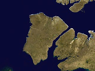
English: Banks Island in the Canadian arctic. Satellite view. NASA blue pearl data. |
| تریخ | ۹ اپریل ۲۰۰۶ (upload date) |
| سروت | Satellite imagery taken from NASA World Wind software (by screenshot) |
| لکھاری | NASA |
لائسنس –
| This image is in the public domain because it is a screenshot from NASA’s globe software World Wind using a public domain layer, such as Blue Marble, MODIS, Landsat, SRTM, USGS or GLOBE.
|
 |
فائل دی تریخ
فائل نو اس ویلے دی حالت وچ ویکھن واسطے تاریخ/ویلے تے کلک کرو۔
| تریخ تے ویلہ | نکی مورت | پاسے | ورتن والا | تیپّݨی کرو | |
|---|---|---|---|---|---|
| موجودہ | ۲۰:۴۹, ۹ اپریل ۲۰۰۶ | | ۱,۲۸۰ × ۹۴۸ (۱۰۹ کلوبائٹ) | Finlay McWalter | Banks Island in the Canadian arctic. NASA blue pearl data, collecter using NASA World Wind. {{PD-USGov-NASA}} Category:Satellite images of islands Category:Satellite pictures of Canada |
فائل دی ورتوں
تھلے دتے گئے 1 صفحے اس فائل نال جُڑدے نیں
فائل ویاپک ورتوں
ایہہ دوجے وکیاں ایس فائل نوں ورتدے نیں –
- af.wikipedia.org تے ورتوں
- ar.wikipedia.org تے ورتوں
- ast.wikipedia.org تے ورتوں
- az.wikipedia.org تے ورتوں
- ba.wikipedia.org تے ورتوں
- be.wikipedia.org تے ورتوں
- bg.wikipedia.org تے ورتوں
- ca.wikipedia.org تے ورتوں
- ceb.wikipedia.org تے ورتوں
- cy.wikipedia.org تے ورتوں
- de.wikipedia.org تے ورتوں
- el.wikipedia.org تے ورتوں
- en.wikiversity.org تے ورتوں
- eo.wikipedia.org تے ورتوں
- es.wikipedia.org تے ورتوں
- et.wikipedia.org تے ورتوں
- eu.wikipedia.org تے ورتوں
- fr.wikipedia.org تے ورتوں
- fr.wikivoyage.org تے ورتوں
- ga.wikipedia.org تے ورتوں
- he.wikipedia.org تے ورتوں
- hy.wikipedia.org تے ورتوں
- it.wikipedia.org تے ورتوں
- ja.wikipedia.org تے ورتوں
- ko.wikipedia.org تے ورتوں
- lt.wikipedia.org تے ورتوں
- lv.wikipedia.org تے ورتوں
- nl.wikipedia.org تے ورتوں
- nn.wikipedia.org تے ورتوں
- pl.wikipedia.org تے ورتوں
- pt.wikipedia.org تے ورتوں
- ro.wikipedia.org تے ورتوں
- ru.wikipedia.org تے ورتوں
ایس فائل دا ویکھو ہور جگت ورتن .