
فائل:Zabul districts.png

ایس وکھالے دا ناپ: ۷۸۹ × ۶۰۰ پکسلز۔ دوجے ریزولوشنز: ۳۱۶ × ۲۴۰ پکسلز | ۶۳۲ × ۴۸۰ پکسلز | ۱,۰۰۰ × ۷۶۰ پکسلز ۔
اصل فائل (۱,۰۰۰ × ۷۶۰ پکسلز, فائل حجم: ۱۹ کلوبائٹ, MIME type: image/png)

|
This map image could be re-created using vector graphics as an SVG file. This has several advantages; see Commons:Media for cleanup for more information. If an SVG form of this image is available, please upload it and afterwards replace this template with
{{vector version available|new image name}}.
It is recommended to name the SVG file “Zabul districts.svg”—then the template Vector version available (or Vva) does not need the new image name parameter. |
خلاصہ
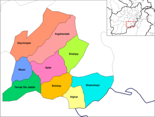
English: Map of the districts of Zabol province of Afghanistan. Created by Rarelibra 19:34, 29 March 2007 (UTC) for public domain use, using MapInfo Professional v8.5 and various mapping resources.
لائسنس –
| اس کم نوں لوکاں لئی ایدے لکھاریRarelibra نے دے دتا اے، اے سارے جگ واسطے لاگو اے۔ کج ملکاں چ قانونی طور تے اے ممکن نئیں اے؛ اگر انج ای اے ے: |
پہلا اپلوڈ دا ریکارڈ
| date/time | username | resolution | size | edit summary | |
|---|---|---|---|---|---|
| 19:34, 29 March 2007 | User:Rarelibra | <a href="http://upload.wikimedia.org/wikipedia/commons/b/bc/Zabol_districts.png"><img alt="Thumbnail for version as of 19:34, 29 March 2007" src="http://upload.wikimedia.org/wikipedia/commons/thumb/b/bc/Zabol_districts.png/120px-Zabol_districts.png" width="120" height="93" border="0" /></a> | 1,056×816 | 29 KB | Map of the districts of Zabol province of Afghanistan. Created by ~~~~ for public domain use, using MapInfo Professional v8.5 and various mapping resources. |
فائل دی تریخ
فائل نو اس ویلے دی حالت وچ ویکھن واسطے تاریخ/ویلے تے کلک کرو۔
| تریخ تے ویلہ | نکی مورت | پاسے | ورتن والا | تیپّݨی کرو | |
|---|---|---|---|---|---|
| موجودہ | ۰۰:۱۴, ۱۵ فروری ۲۰۲۴ | | ۱,۰۰۰ × ۷۶۰ (۱۹ کلوبائٹ) | User-duck | Cropped 5 % horizontally, 7 % vertically using CropTool with lossless mode. |
| ۰۲:۴۳, ۱۳ مارچ ۲۰۰۹ |  | ۱,۰۵۶ × ۸۱۶ (۲۹ کلوبائٹ) | BetacommandBot | move approved by: User:Lokal Profil This image was moved from File:Zabol districts.png == Summary == Map of the districts of Zabol province of Afghanistan. Created by Rarelibra 19:34, 29 March 2007 (UTC) for public domain use |
فائل دی ورتوں
تھلے دتے گئے 1 صفحے اس فائل نال جُڑدے نیں
فائل ویاپک ورتوں
ایہہ دوجے وکیاں ایس فائل نوں ورتدے نیں –
- ar.wikipedia.org تے ورتوں
- ca.wikipedia.org تے ورتوں
- da.wikipedia.org تے ورتوں
- de.wikipedia.org تے ورتوں
- en.wikipedia.org تے ورتوں
- eo.wikipedia.org تے ورتوں
- es.wikipedia.org تے ورتوں
- fi.wikipedia.org تے ورتوں
- fr.wikipedia.org تے ورتوں
- he.wikipedia.org تے ورتوں
- incubator.wikimedia.org تے ورتوں
- it.wikipedia.org تے ورتوں
- lt.wikipedia.org تے ورتوں
- mn.wikipedia.org تے ورتوں
- ms.wikipedia.org تے ورتوں
- nl.wikipedia.org تے ورتوں
- no.wikipedia.org تے ورتوں
- pl.wikipedia.org تے ورتوں
- ps.wikipedia.org تے ورتوں
- pt.wikipedia.org تے ورتوں
- ru.wikipedia.org تے ورتوں
- simple.wikipedia.org تے ورتوں
- sk.wikipedia.org تے ورتوں
- ta.wikipedia.org تے ورتوں
- tr.wikipedia.org تے ورتوں
- ur.wikipedia.org تے ورتوں
- uz.wikipedia.org تے ورتوں