
فائل:3823 - Riffelberg - View from Gornergratbahn.JPG

ایس وکھالے دا ناپ: ۸۰۰ × ۶۰۰ پکسلز۔ دوجے ریزولوشنز: ۳۲۰ × ۲۴۰ پکسلز | ۶۴۰ × ۴۸۰ پکسلز | ۱,۰۲۴ × ۷۶۸ پکسلز | ۱,۲۸۰ × ۹۶۰ پکسلز | ۲,۵۶۰ × ۱,۹۲۰ پکسلز | ۳,۶۴۸ × ۲,۷۳۶ پکسلز ۔
اصل فائل (۳,۶۴۸ × ۲,۷۳۶ پکسلز, فائل حجم: ۲.۶۹ میگابائٹ, MIME type: image/jpeg)
| تفصیل |
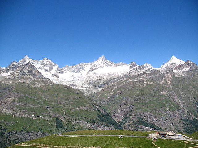
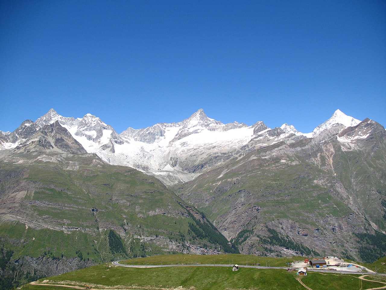
Deutsch: Ausblick von der Gornergratbahn, Riffelberg / Zermatt, Schweiz. Im Hintergrund von links nach rechts der Ober Gabelhorn (4.063 m.ü.M.), Wellenkuppe (3.903 m.ü.M.), Trifthorn (3.728 m.ü.M.), Pointe du Mountet (3.877 m.ü.M.), Zinalrothorn (4.221 m.ü.M., Bildmitte), Pointe Sud du Moming (3.963 m.ü.M.), Schahhorn (3.974,5 m.ü.M.) und Weisshorn (4.505 m). Im Vordergrund, vor den Ober Gabelhorn, liegt der Unter Gabelhorn (3.391,7 m.ü.M.). In den Grat laufend vom Zinalrothorn liegen zwei Nebengipfel, der Ober Äschhorn (3669 m.ü.M.) und der Unter Äschhorn (3.618 m.ü.M.). Weiter gibt es im Vordergrund von links nach rechts den Wisshorn (2.936 m.ü.M.), den Platthorn (3.345 m.ü.M.) und den Mettelhorn (3.406,0 m.ü.M.). Alle gehören zu den Walliser Alpen
English: View from the Gornergratbahn, Riffelberg / Zermatt, Switzerland. In the background from the left to the right the Ober Gabelhorn (4063 metres), Wellenkuppe (3903 m), Trifthorn (3728 m), Pointe du Mountet (3877 m), Zinalrothorn (4221 m, centre of the image), Pointe Sud du Moming (3963 m), Schahhorn (3974.5 m) and Weisshorn (4505 m). In the foreground, in front of the Ober Gabelhorn, lies the Unter Gabelhorn (3391.7 m). In the ridge coming from the Zinalrothorn are two side summits, the Ober Äschhorn (3669 m) and the Unter Äschhorn (3618 m). Further one can find in the foreground, from left to right, the Wisshorn (2936 m), Platthorn (3345 m) and Mettelhorn (3406.0 m). All mountains are part of the Wallis or Pennine Alps
Nederlands: Blik vanaf de Gornergratbahn, Riffelberg/Zermatt, Zwitserland. In de achtergrond van links naar rechts de Ober Gabelhorn (4063 meter), de Wellenkuppe (3903 m), de Trifthorn (3728 m), de Pointe du Mountet (3877 m), de Zinalrothorn (4221 m, midden op de foto), Pointe Sud du Moming (3963 m), Schahhorn (3974,5 m) en de Weisshorn. Op de voorgrond, voor de Ober Gabelhorn, ligt de Unter Gabelhorn (3391,7 m). In de graat lopend vanaf de top van de Zinalrothorn liggen twee neventoppen, de Ober Äschhorn (3669 m) en de Unter Äschhorn (3618 m). Verder zijn op de voorgrond, van links naar rechts, de Wisshorn (2936 m), de Platthorn (3345 m) en de Mettelhorn (3406.0 m) te zien. Alle bergen maken deel uit van de Walliser Alpen
|
||||
| تریخ | |||||
| سروت | آپݨا کم | ||||
| لکھاری | Andrew Bossi | ||||
| اجازت (فائل نوں دوبارہ ورتنا) |
Own work, share alike, attribution required (Creative Commons CC-BY-SA-2.5) |
میں، اس کم دے کاپیرائٹ دا مالک، اس کم نوں اس لائسنس دے مطابق چھاپدا واں:
ایس فائل نوں کریٹو کامنز Attribution 2.5 جنرک لائسنس دتا گیا.
- تہانوں کھلھ اے:
- حصہ کرنا – کاپی، ونڈنا تے کم بھیجنا
- فیر رلانا – کم نوں فٹ کرنا
- تھلے دتیاں شرطاں نال:
- کس دے ناں – تسیں لازمی ایس کم دے بناں والے بارے دسو جنج اونے آکھیا اے یا جنج لسنس چ آکھیا گیا ہے۔
- اکو جہا شئیر کرو۔ – اگر تسیں بدلدے یا ایس کم تے بناندے تے بنن والے کم نوں اینج دے لسنس نال ای ونڈو گے۔
| Annotations | This image is annotated: View the annotations at Commons |
فائل دی تریخ
فائل نو اس ویلے دی حالت وچ ویکھن واسطے تاریخ/ویلے تے کلک کرو۔
| تریخ تے ویلہ | نکی مورت | پاسے | ورتن والا | تیپّݨی کرو | |
|---|---|---|---|---|---|
| موجودہ | ۰۳:۲۸, ۴ نومبر ۲۰۰۷ | | ۳,۶۴۸ × ۲,۷۳۶ (۲.۶۹ میگابائٹ) | Thisisbossi | {{Information |Description={{de|Schauen vom die Gornergratbahn, Riffelberg / Zermatt, Schweiz}} {{en|View from the Gornergratbahn, [[:en:Riffelberg|Riffelberg |
فائل دی ورتوں
تھلے دتے گئے 1 صفحے اس فائل نال جُڑدے نیں
فائل ویاپک ورتوں
ایہہ دوجے وکیاں ایس فائل نوں ورتدے نیں –
- de.wikipedia.org تے ورتوں
- fr.wikipedia.org تے ورتوں
- it.wikipedia.org تے ورتوں
- nn.wikipedia.org تے ورتوں