
فائل:Almohads1200.png

ایس وکھالے دا ناپ: ۸۰۰ × ۴۹۷ پکسلز۔ دوجے ریزولوشنز: ۳۲۰ × ۱۹۹ پکسلز | ۶۴۰ × ۳۹۸ پکسلز | ۸۴۶ × ۵۲۶ پکسلز ۔
اصل فائل (۸۴۶ × ۵۲۶ پکسلز, فائل حجم: ۱۹ کلوبائٹ, MIME type: image/png)

|
This historical map image could be re-created using vector graphics as an SVG file. This has several advantages; see Commons:Media for cleanup for more information. If an SVG form of this image is available, please upload it and afterwards replace this template with
{{vector version available|new image name}}.
It is recommended to name the SVG file “Almohads1200.svg”—then the template Vector version available (or Vva) does not need the new image name parameter. |
خلاصہ
| تفصیل |
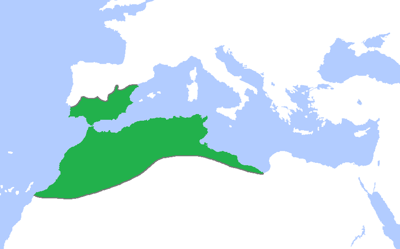
English: Locator map of the Almohad dynasty at its greatest extent, c. 1200.
(Partially based on Atlas of World History (2007) - The World 1000-1200, map) |
| تریخ | |
| سروت | آپݨا کم |
| لکھاری | Gabagool |
لائسنس –
میں، اس کم دے کاپیرائٹ دا مالک، اس کم نوں اس لائسنس دے مطابق چھاپدا واں:
ایس فائل نوں کریٹو کامنز Attribution 3.0 انپورٹڈ لائسنس دتا گیا.
- تہانوں کھلھ اے:
- حصہ کرنا – کاپی، ونڈنا تے کم بھیجنا
- فیر رلانا – کم نوں فٹ کرنا
- تھلے دتیاں شرطاں نال:
- کس دے ناں – تسیں لازمی ایس کم دے بناں والے بارے دسو جنج اونے آکھیا اے یا جنج لسنس چ آکھیا گیا ہے۔
فائل دی تریخ
فائل نو اس ویلے دی حالت وچ ویکھن واسطے تاریخ/ویلے تے کلک کرو۔
| تریخ تے ویلہ | نکی مورت | پاسے | ورتن والا | تیپّݨی کرو | |
|---|---|---|---|---|---|
| موجودہ | ۰۰:۲۸, ۲ جون ۲۰۰۹ | | ۸۴۶ × ۵۲۶ (۱۹ کلوبائٹ) | Gabagool | further cropped |
| ۱۸:۰۱, ۲۳ مئی ۲۰۰۹ |  | ۱,۱۱۴ × ۶۷۴ (۲۹ کلوبائٹ) | Gabagool | cropped | |
| ۲۰:۴۸, ۲۲ اپریل ۲۰۰۹ |  | ۱,۴۸۱ × ۹۰۲ (۴۶ کلوبائٹ) | Gabagool | {{Information |Description={{en|1=Locator map of the Almohad dynasty at its greatest extent, c. 1200. (Partially based on ''Atlas of World History'' (2007) - The World 1000-1200, map)}} |Source=Own work by uploader |Author=Gabagool / Ja |
فائل دی ورتوں
تھلے دتے گئے 2 صفحے اس فائل نال جُڑدے نیں
فائل ویاپک ورتوں
ایہہ دوجے وکیاں ایس فائل نوں ورتدے نیں –
- als.wikipedia.org تے ورتوں
- an.wikipedia.org تے ورتوں
- ast.wikipedia.org تے ورتوں
- az.wikipedia.org تے ورتوں
- ba.wikipedia.org تے ورتوں
- be.wikipedia.org تے ورتوں
- bn.wikipedia.org تے ورتوں
- ckb.wikipedia.org تے ورتوں
- da.wikipedia.org تے ورتوں
- de.wikipedia.org تے ورتوں
- en.wikipedia.org تے ورتوں
- es.wikipedia.org تے ورتوں
- eu.wikipedia.org تے ورتوں
- fa.wikipedia.org تے ورتوں
- fi.wikipedia.org تے ورتوں
- fr.wikipedia.org تے ورتوں
- hy.wikipedia.org تے ورتوں
- id.wikipedia.org تے ورتوں
- ja.wikipedia.org تے ورتوں
- mk.wikipedia.org تے ورتوں
- ms.wikipedia.org تے ورتوں
- no.wikipedia.org تے ورتوں
- pl.wikipedia.org تے ورتوں
- pt.wikipedia.org تے ورتوں
ایس فائل دا ویکھو ہور جگت ورتن .