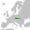
فائل:Czechoslovak Republic (1939).svg
Page contents not supported in other languages.
Appearance
آزاد انسائیکلوپیڈیا، وکیپیڈیا توں

Size of this PNG preview of this SVG file: ۴۵۰ × ۴۵۶ پکسلز. دوجے ریزولوشنز: ۲۳۷ × ۲۴۰ پکسلز | ۴۷۴ × ۴۸۰ پکسلز | ۷۵۸ × ۷۶۸ پکسلز | ۱,۰۱۱ × ۱,۰۲۴ پکسلز | ۲,۰۲۱ × ۲,۰۴۸ پکسلز ۔
اصل فائل (ایس وی جی فائل، پکسل:۴۵۰ × ۴۵۶، فائل سائز: ۴۵۳ کلوبائٹ)
ایہ فائل Wikimedia Commons توں اے تے دوجیاں ویونتاں تے وی ورتی جاسکدی اے۔ گل بات اس دے فائل گل بات صفحہ تے تھلے دتی گئی۔
Captions
Add a one-line explanation of what this file represents
Items portrayed in this file
چترن
creator English
some value
copyright status English
copyrighted English
۱۷ دسمبر 2012
source of file English
original creation by uploader English
media type English
image/svg+xml
checksum English
ecb04cd38b404f97594741e46c0467b066536026
data size English
۴۶۳,۷۸۰ بائٹ
height English
۴۵۶ pixel
width English
۴۵۰ pixel
فائل دی تریخ
فائل نو اس ویلے دی حالت وچ ویکھن واسطے تاریخ/ویلے تے کلک کرو۔
| تریخ تے ویلہ | نکی مورت | پاسے | ورتن والا | تیپّݨی کرو | |
|---|---|---|---|---|---|
| موجودہ | ۲۲:۱۸, ۲۵ جولائی ۲۰۱۳ |  | ۴۵۰ × ۴۵۶ (۴۵۳ کلوبائٹ) | Alphathon | Removed the Flevoland polders (Netherlands) which were not completed until 1942/1968 |
| ۰۴:۰۳, ۱۸ دسمبر ۲۰۱۲ |  | ۴۵۰ × ۴۵۶ (۴۵۴ کلوبائٹ) | TRAJAN 117 | {{Information |Description ={{en|1=The Czechoslovak Republic in 1939.}} |Source ={{own}} {{AttribSVG|Blank map of Europe October 1938 - March 1939.svg|Alphathon}} |Author =TRAJAN 117 {{created with Inkscape}} |Dat... |
فائل دی ورتوں
اس فائل نال جڑیا کوئی صفحہ نئیں۔
فائل ویاپک ورتوں
ایہہ دوجے وکیاں ایس فائل نوں ورتدے نیں –
- als.wikipedia.org تے ورتوں
- bg.wikipedia.org تے ورتوں
- cs.wikipedia.org تے ورتوں
- de.wikipedia.org تے ورتوں
- en.wikipedia.org تے ورتوں
- eo.wikipedia.org تے ورتوں
- es.wikipedia.org تے ورتوں
- et.wikipedia.org تے ورتوں
- eu.wikipedia.org تے ورتوں
- fa.wikipedia.org تے ورتوں
- fr.wikipedia.org تے ورتوں
- he.wikipedia.org تے ورتوں
- id.wikipedia.org تے ورتوں
- it.wikipedia.org تے ورتوں
- ko.wikipedia.org تے ورتوں
- lv.wikipedia.org تے ورتوں
- ms.wikipedia.org تے ورتوں
- mt.wikipedia.org تے ورتوں
- nl.wikipedia.org تے ورتوں
- pl.wikipedia.org تے ورتوں
- pt.wikipedia.org تے ورتوں
- ru.wikipedia.org تے ورتوں
- sh.wikipedia.org تے ورتوں
- sk.wikipedia.org تے ورتوں
- sq.wikipedia.org تے ورتوں
- th.wikipedia.org تے ورتوں
- tr.wikipedia.org تے ورتوں
- uk.wikipedia.org تے ورتوں
- vi.wikipedia.org تے ورتوں
- zh.wikipedia.org تے ورتوں
میٹا ڈیٹا
اس فائل وچ ہور وی معلومات نے، شاید او ڈیجیٹل کیمرے یا سکینر نے پائیاں گئیاں نے جس نال اینو کچھیا یا ڈیجیٹل بنایا گیا اے۔
اگر فائل نو ایدی اصلی حالت توں تبدیل کیتا گیا اے تے کجھ تفصیلات تبدیل ہوئی فائل دے بارے چ نئیں دسن گیاں۔
| نکی سرخی | Countries of Europe |
|---|---|
| مورت دا ناں | A blank Map of Europe. Every country has an id which is its ISO-3166-1-ALPHA2 code in lower case.
Members of the EU have a class="eu", countries in europe (which I found turkey to be but russia not) have a class="europe".
Certain countries are further subdivided the United Kingdom has gb-gbn for Great Britain and gb-nir for Northern Ireland. Russia is divided into ru-kgd for the Kaliningrad Oblast and ru-main for the Main body of Russia. There is the additional grouping #xb for the "British Islands" (the UK with its Crown Dependencies - Jersey, Guernsey and the Isle of Man)

Contributors.
Original Image: (http://commons.wikimedia.org/wiki/Image:Europe_countries.svg) Júlio Reis (http://commons.wikimedia.org/wiki/User:Tintazul).
Recolouring and tagging with country codes: Marian "maix" Sigler (http://commons.wikimedia.org/wiki/User:Maix)
Improved geographical features: http://commons.wikimedia.org/wiki/User:W!B:
Updated to reflect dissolution of Serbia & Montenegro: http://commons.wikimedia.org/wiki/User:Zirland
Updated to include British Crown Dependencies as seperate entities and regroup them as "British Islands", with some simplifications to the XML and CSS: James Hardy (http://commons.wikimedia.org/wiki/User:MrWeeble)
Released under CreativeCommons Attribution ShareAlike (http://creativecommons.org/licenses/by-sa/2.5/). |
| چوڑائی | 450 |
| اچائی | 456 |


