
فائل:Eyjafjallajökull.jpeg

ایس وکھالے دا ناپ: ۸۰۰ × ۵۳۶ پکسلز۔ دوجے ریزولوشنز: ۳۲۰ × ۲۱۴ پکسلز | ۶۴۰ × ۴۲۹ پکسلز | ۱,۰۲۴ × ۶۸۶ پکسلز | ۱,۲۸۰ × ۸۵۸ پکسلز | ۲,۹۶۰ × ۱,۹۸۳ پکسلز ۔
اصل فائل (۲,۹۶۰ × ۱,۹۸۳ پکسلز, فائل حجم: ۳.۹۶ میگابائٹ, MIME type: image/jpeg)
| تفصیل |
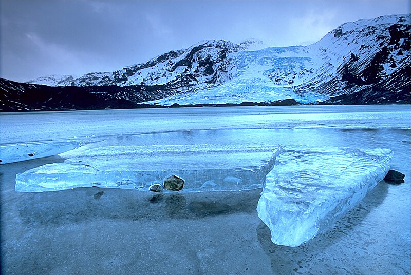
English: Gígjökull, an outlet glacier extending from Eyjafjallajökull, Iceland. Lónið is the lake visible in the foreground.
Tiếng Việt: Sông băng Eyjafjallajökull tại Iceland.
Photo was taken using the following technique:
|
||
| تریخ | 2003-02-13, 11:00–12:00 | ||
| سروت |
آپݨا کم: http://fam-tille.de/sparetime.html |
||
| لکھاری | Andreas Tille | ||
| اجازت (فائل نوں دوبارہ ورتنا) |
Quote of http://fam-tille.de/island/winter/0213/2003_093.html - Permission is granted to copy, distribute and/or modify this images under the terms of the GNU Free Documentation License, Version 1.1 or any later version published by the Free Software Foundation. میں، اس کم دے کاپیرائٹ دا مالک، اس کم نوں اس لائسنس دے مطابق چھاپدا واں:
ایہ فائل ایس لسنس Creative Commons Attribution-Share Alike 3.0 Unported, 2.5 Generic, 2.0 Generic and 1.0 Generic نال چلدی اے۔
تسیں اپنی مرضی دا لائسنس چݨ سکدے اوہ۔ |

| Camera location | | View this and other nearby images on: OpenStreetMap |
|---|
| Annotations | This image is annotated: View the annotations at Commons |
Assessment
|
This image was selected as picture of the day on Wikimedia Commons for 21 December 2004. It was captioned as follows: Other languages:
Esperanto: Glaciejo Eyjafjallajökull en Islando |
This image was selected as picture of the day on Vietnamese Wikipedia.
|
فائل دی تریخ
فائل نو اس ویلے دی حالت وچ ویکھن واسطے تاریخ/ویلے تے کلک کرو۔
| تریخ تے ویلہ | نکی مورت | پاسے | ورتن والا | تیپّݨی کرو | |
|---|---|---|---|---|---|
| موجودہ | ۱۷:۰۱, ۲ دسمبر ۲۰۰۴ | | ۲,۹۶۰ × ۱,۹۸۳ (۳.۹۶ میگابائٹ) | Ævar Arnfjörð Bjarmason |
فائل دی ورتوں
اس فائل نال جڑیا کوئی صفحہ نئیں۔
فائل ویاپک ورتوں
ایہہ دوجے وکیاں ایس فائل نوں ورتدے نیں –
- af.wikipedia.org تے ورتوں
- an.wikipedia.org تے ورتوں
- arc.wikipedia.org تے ورتوں
- ar.wikipedia.org تے ورتوں
- arz.wikipedia.org تے ورتوں
- azb.wikipedia.org تے ورتوں
- be.wikipedia.org تے ورتوں
- bg.wikipedia.org تے ورتوں
- bg.wikinews.org تے ورتوں
- bo.wikipedia.org تے ورتوں
- br.wikipedia.org تے ورتوں
- bs.wikipedia.org تے ورتوں
- ca.wikipedia.org تے ورتوں
- co.wikipedia.org تے ورتوں
- cs.wikipedia.org تے ورتوں
- da.wikipedia.org تے ورتوں
- de.wikipedia.org تے ورتوں
- Eisscholle
- Benutzer:Rainbowfish/Test10
- Wikipedia:Kandidaten für exzellente Bilder/Archiv2005/7
- Wikipedia:Archiv/Hilfe:MediaWiki/Versionen
- Benutzer:Torinberl/Testterrain
- Benutzer:Torinberl/Benutzerseite
- Portal Diskussion:Island/Bild des Monats
- Benutzer Diskussion:Placebo111
- Portal Diskussion:Island/Bild des Monats/Archiv/2006
- Benutzer:Rainbowfish/Bilder
- Benutzer:Rainbowfish/ALT
- Portal Diskussion:Vulkane/Vulkanbild der Woche
- de.wiktionary.org تے ورتوں
- dsb.wikipedia.org تے ورتوں
- el.wikipedia.org تے ورتوں
- en.wikipedia.org تے ورتوں
ایس فائل دا ویکھو ہور جگت ورتن .