
فائل:Punjab 1903.gif
Punjab_1903.gif (۶۴۰ × ۴۸۰ پکسلز, فائل حجم: ۳۳۸ کلوبائٹ, MIME type: image/gif)
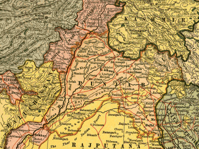
In this map, the British Raj Punjab province is colored pink, and the Indian princely states are colored yellow. As the map indicates, a number of princely states, mostly in the eastern Punjab, fell under the political authority of the British Governor of the Punjab. From map of India by Dodd, Mead and Company, 1903. Library of Congress Geography and Map Collection. Call Number G7650 1903 .D6 TIL
|
This work is in the public domain in its country of origin and other countries and areas where the copyright term is the author's life plus 70 years or fewer. | |
| ایہ فائل دے بارے چ دس اے جے اے کاپی حف دیاں روکاں توں کھلی اے تے نالدے رلدے حقاں توں وی۔ | |
فائل دی تریخ
فائل نو اس ویلے دی حالت وچ ویکھن واسطے تاریخ/ویلے تے کلک کرو۔
| تریخ تے ویلہ | نکی مورت | پاسے | ورتن والا | تیپّݨی کرو | |
|---|---|---|---|---|---|
| موجودہ | ۱۷:۵۴, ۶ مئی ۲۰۰۵ | | ۶۴۰ × ۴۸۰ (۳۳۸ کلوبائٹ) | Shauni | In this map, the British Raj Punjab province is colored pink, and the Indian princely states are colored yellow. As the map indicates, a number of princely states, mostly in the eastern Punjab, fell under the political authority of the British Gov |
فائل دی ورتوں
تھلے دتے گئے 2 صفحے اس فائل نال جُڑدے نیں
فائل ویاپک ورتوں
ایہہ دوجے وکیاں ایس فائل نوں ورتدے نیں –
- ar.wikipedia.org تے ورتوں
- bg.wikipedia.org تے ورتوں
- bn.wikipedia.org تے ورتوں
- br.wikipedia.org تے ورتوں
- ca.wikipedia.org تے ورتوں
- en.wikipedia.org تے ورتوں
- es.wikipedia.org تے ورتوں
- fi.wikipedia.org تے ورتوں
- hi.wikipedia.org تے ورتوں
- it.wikipedia.org تے ورتوں
- ko.wikipedia.org تے ورتوں
- ml.wikipedia.org تے ورتوں
- nn.wikipedia.org تے ورتوں
- ur.wikipedia.org تے ورتوں
- www.wikidata.org تے ورتوں
- zh.wikipedia.org تے ورتوں