
فائل:SAM pol.png

ایس وکھالے دا ناپ: ۵۵۲ × ۵۹۹ پکسلز۔ دوجے ریزولوشنز: ۲۲۱ × ۲۴۰ پکسلز | ۴۴۲ × ۴۸۰ پکسلز | ۹۷۶ × ۱,۰۵۹ پکسلز ۔
اصل فائل (۹۷۶ × ۱,۰۵۹ پکسلز, فائل حجم: ۵۵۸ کلوبائٹ, MIME type: image/png)
Permission is granted to copy, distribute and/or modify this document under the terms of the GNU Free Documentation License, Version 1.2 or any later version published by the Free Software Foundation; with no Invariant Sections, no Front-Cover Texts, and no Back-Cover Texts. A copy of the license is included in the section entitled GNU Free Documentation License.
خلاصہ
| تفصیل |
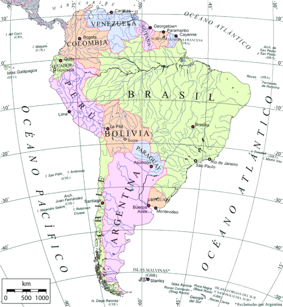
Mapa político de América del Sur en español, capitales, 2 ciudades mayores de Brasil, islas periféricas, ríos. Proyección azimutal equivalente. Political map of South America in spanish, capitals, 2 biggest cities of Brazil, periferical islands, rivers. Azimuthal equal-area Projection |
| تریخ | |
| سروت | Own work over an OMC base map |
| لکھاری | Giovanni Fattori, using OMC base map |
| اجازت (فائل نوں دوبارہ ورتنا) |
Free license |
لائسنس –

|
کاپی کرن، ونڈن تے بدلن دی ایس ڈوکومنٹ لئی اجازت دتی جاندی اے ایہناں GNU Free Documentation License, Version 1.2 شرطاں نال یا مگروں کسے وی چھپے ورین Free Software Foundation توں بنا کسے انویرینٹ سیکشن دے، ناں فرنٹ کور لکھت تے ناں بیک کور لکھت دے۔ لسنس دی اک کاپی سیکشن وچ ہیگی اے جہدا ناں اے GNU Free Documentation License۔ |
| ایس فائل نوں کریٹو کامنز Attribution 2.5 پولینڈ لائسنس دتا گیا. | ||
| ||
| اس لائسنس دا ٹیگ GFDL دے مطابق اس فائل چ پایا گیا اے licensing update۔ |
فائل دی تریخ
فائل نو اس ویلے دی حالت وچ ویکھن واسطے تاریخ/ویلے تے کلک کرو۔
| تریخ تے ویلہ | نکی مورت | پاسے | ورتن والا | تیپّݨی کرو | |
|---|---|---|---|---|---|
| موجودہ | ۱۹:۴۸, ۲۸ مئی ۲۰۰۷ | | ۹۷۶ × ۱,۰۵۹ (۵۵۸ کلوبائٹ) | Pruxo | {{Information |Description=Mapa político de América del Sur en español, capitales, 2 ciudades mayores de Brasil, 1 de ecuador, 1 de bolivia, islas periféricas, ríos. Proyección azimutal equivalente. |Source=trabajo propio sobre el Own work over an |
| ۰۷:۳۰, ۳۰ مارچ ۲۰۰۷ |  | ۹۷۶ × ۱,۰۵۹ (۶۷۶ کلوبائٹ) | Gi | {{Information |Description= Mapa político de América del Sur en español, capitales, 2 ciudades mayores de Brasil, islas periféricas, ríos. Proyección azimutal equivalente. Political map of South America in spanish, capitals, 2 biggest cities of Braz | |
| ۰۴:۲۴, ۱۸ مارچ ۲۰۰۷ |  | ۹۷۶ × ۱,۰۵۹ (۶۷۶ کلوبائٹ) | Gi | {{Information |Description= Mapa político de América del Sur en español, capitales, 2 ciudades mayores de Brasil, islas periféricas, ríos. Proyección azimutal equivalente. Political map of South America in spanish, capitals, 2 biggest cities of Braz |
فائل دی ورتوں
تھلے دتے گئے 1 صفحے اس فائل نال جُڑدے نیں
فائل ویاپک ورتوں
ایہہ دوجے وکیاں ایس فائل نوں ورتدے نیں –
- es.wikipedia.org تے ورتوں
- io.wikipedia.org تے ورتوں
- sr.wikipedia.org تے ورتوں